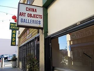
Chinatown is a neighborhood in Downtown Los Angeles, California, that became a commercial center for Chinese and other Asian businesses in Central Los Angeles in 1938. The area includes restaurants, shops, and art galleries, but also has a residential neighborhood with a low-income, aging population of about 7,800 residents.

Thai Town is a neighborhood in Central Los Angeles, California. In 2008, it was one of the five Asian Pacific Islander neighborhoods in the city that received federal recognition as a Preserve America neighborhood. It is the only officially recognized Thai Town in the United States.

Exposition Park is a 160-acre urban park (65 ha) in the south region of Los Angeles, California, in the Exposition Park neighborhood. Established in 1872 as an agricultural fairground, the park includes the Los Angeles Memorial Coliseum, BMO Stadium, the California Science Center, the Natural History Museum of Los Angeles County, and the California African American Museum. The Lucas Museum of Narrative Art is under construction. Bounded by Exposition Boulevard to the north, South Figueroa Street to the east, Martin Luther King Jr. Boulevard to the south and Vermont Avenue to the west, it is directly south of the main campus of the University of Southern California.

The Asian-American influx to the San Gabriel Valley grew rapidly when Chinese began settling in Monterey Park, California, in the western San Gabriel Valley in the 1970s. Just east of Los Angeles, the region has achieved international prominence as a hub of overseas Chinese, or hua qiao. Although Chinese immigrants were a noteworthy presence in the establishment of Southern California from the 19th century, significant Chinese migration to suburban San Gabriel Valley coincided with a trend of white out-migration from the 1970s onward. This opened an opportunity for middle-class Asian Americans to begin settling in the San Gabriel Valley.

Roy and Edna Disney CalArts Theater (REDCAT) is an interdisciplinary contemporary arts center for innovative visual, performing and media arts in downtown Los Angeles, located inside the Walt Disney Concert Hall complex. The California Institute of the Arts opened the space in November 2003 as an extension of the college’s mission into downtown Los Angeles.

Gallery Row is a neighborhood in Downtown Los Angeles designated by the City Council in 2003 to promote the concentration of art galleries along Main Street and Spring Street.

Beverly Boulevard is one of the main east–west thoroughfares in Los Angeles, in the U.S. state of California. It begins off Santa Monica Boulevard in Beverly Hills and ends on the Lucas Avenue overpass near downtown Los Angeles to become 1st Street. A separate Beverly Boulevard begins off 3rd Street and Pomona Boulevard in East Los Angeles, runs through Montebello and Pico Rivera, and becomes Turnbull Canyon Road in Whittier near Rose Hills Memorial Park.

The Village is a recording studio located at 1616 Butler Avenue in West Los Angeles, California.
This is an alphabetical index of topics related to Asian Americans.

Barnsdall Art Park is a city park located in the East Hollywood district of Los Angeles, California. Parking and arts buildings access is from Hollywood Boulevard on the north side of the park. The park is a Los Angeles Historic-Cultural Monument, and a facility of the City of Los Angeles Department of Cultural Affairs.
Los Angeles Street, originally known as Calle de los Negros is a major thoroughfare in Downtown Los Angeles, California, dating back to the origins of the city as the Pueblo de Los Ángeles.

Betalevel is a venue located in a basement down an alley in Chinatown, Los Angeles, behind a Chinese restaurant, underneath the shops and art galleries of Chung King Road.
Alameda Street is a major north-south thoroughfare in Los Angeles County, California. It is approximately 21 miles in length, running from Harry Bridges Boulevard in Wilmington; and through Carson, Compton, Lynwood, Watts, Florence-Graham, Huntington Park, Vernon and Arts District to Spring and College in Chinatown. For much of its length, Alameda runs through present and former industrial corridors, and is paralleled by Union Pacific Railroad tracks.
Vielmetter Los Angeles is a contemporary art gallery founded in 2000 by Susanne Vielmetter. The gallery is located in downtown Los Angeles.

Hill Street is a major north–south thoroughfare in Los Angeles, measuring 4.8 miles (7.7 km) in length. It starts on Martin Luther King, Jr. Boulevard near the campus of USC, and passes north through Downtown Los Angeles, past such landmarks as Pershing Square, the Subway Terminal Building, Angels Flight, Fort Moore and Chinatown. Hill Street merges with the Arroyo Seco Parkway near Dodger Stadium.
Charlie James Gallery is a contemporary art gallery located in the Chinatown neighborhood of Los Angeles.

China Art Objects Galleries is a contemporary art gallery co-founded by a group of artists in Los Angeles in 1999. Founder Steve Hanson moved the gallery to Mérida, Mexico in 2021.
Coagula Curatorial is a contemporary art gallery founded in April 2012 by Mat Gleason, Los Angeles art critic & curator. From 1992-2011, Gleason published Coagula Art Journal, a free zine-style publication on contemporary art, which gained notoriety for its "no holds barred" critique of the contemporary art world.
Redling Fine Art is a contemporary art gallery in Los Angeles, California, United States.
Track 16 is a contemporary art gallery in the fashion district neighborhood of downtown Los Angeles, exhibiting the work of contemporary artists.


