Monmouth is a town and community in Wales. It is situated where the River Monnow joins the River Wye, 2 miles (3.2 km) from the Wales–England border. Monmouth is 30 miles (48 km) northeast of Cardiff, and 113 miles (182 km) west of London. It is within the Monmouthshire local authority, and the parliamentary constituency of Monmouth. The population in the 2011 census was 10,508, rising from 8,877 in 2001. Monmouth is the historic county town of Monmouthshire although Abergavenny is now the county town.
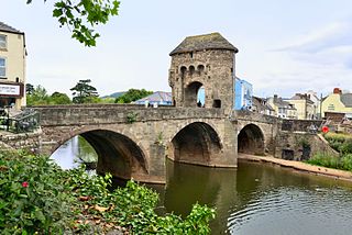
Monnow Bridge, in Monmouth, Wales, is the only remaining fortified river bridge in Great Britain with its gate tower standing on the bridge. Such bridge towers were common across Europe from medieval times, but many were destroyed due to urban expansion, diminishing defensive requirements and the increasing demands of traffic and trade. The historical and architectural importance of the bridge and its rarity are reflected in its status as a scheduled monument and a Grade I listed building. The bridge crosses the River Monnow 500 metres (1,600 ft) above its confluence with the River Wye.
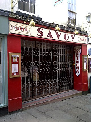
The Savoy Theatre, Church Street, Monmouth is a theatre and cinema, reputedly the oldest working theatre site in Wales. It has a capacity for 360 people and is run by a charitable trust. One of 24 buildings on the Monmouth Heritage Trail, the theatre is a Grade II* listed building.

St Mary's Priory Church, in Whitecross Street, Monmouth, Monmouthshire, Wales, is an Anglican church founded as a Benedictine priory in 1075. The current church dates mostly from the 18th and 19th centuries. It was designated a Grade II* listed building in 1952. It is one of 24 buildings on the Monmouth Heritage Trail.

Monmouth Priory, in Priory Street, Monmouth, Wales, is a building that incorporates the remains of the monastic buildings attached to St Mary's Priory Church. The priory was a Benedictine foundation of 1075, and parts of the mediaeval buildings remain. The buildings were substantially redeveloped in the nineteenth century for use as St Mary's National School, and now form a community centre. The complex is a Grade II* listed building as of 27 June 1952. It is one of 24 sites on the Monmouth Heritage Trail.

The Market Hall, in Priory Street, Monmouth, Wales, is an early Victorian building by the prolific Monmouth architect George Vaughan Maddox. It was constructed in the years 1837–39 as the centrepiece of a redevelopment of part of Monmouth town centre. After being severely damaged by fire in 1963, it was partly rebuilt and is now the home of Monmouth Museum. At the rear of the building are original slaughterhouses, called The Shambles, opening onto the River Monnow. The building is Grade II listed as at 27 June 1952, and it is one of 24 buildings on the Monmouth Heritage Trail. The Shambles slaughterhouses are separately listed as Grade II*.
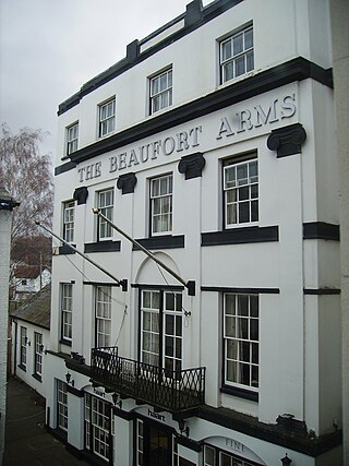
The Beaufort Arms Hotel, Agincourt Square, Monmouth, Monmouthshire, south-east Wales is a former coaching inn dating from the early eighteenth century, though the frontage may have been modified by the prolific early Victorian architect George Vaughan Maddox in the 1830s. A stone cornice on the central block still carries the inscription "The Beaufort Arms". It is a Grade II* listed building as of 27 June 1952. It is one of 24 buildings on the Monmouth Heritage Trail.

Agincourt House, No. 1 Agincourt Square, Monmouth, Monmouthshire, Wales is a notable early seventeenth century half-timbered building.
The Angel Hotel, Church Street, Monmouth, Monmouthshire, south-east Wales is a Grade II listed building. The building was in use as an inn in 1700 and closed in 1985, the longest period of continuous history of any public house in Monmouth. The building is of three storeys, with a roof of Welsh slate and a wooden Doric doorcase. During the late nineteenth century, the hotel was the headquarters of the Monmouth Branch of the Cyclists Touring Club. It is now a furniture shop, and one of 24 buildings on the Monmouth Heritage Trail.

George Vaughan Maddox was a nineteenth-century British architect and builder, whose work was undertaken principally in the town of Monmouth, Wales, and in the wider county. Working mainly in a Neo-Classical style, his extensive output made a significant contribution to the Monmouth townscape. The architectural historian John Newman considers that Monmouth owes to Maddox "its particular architectural flavour. For two decades from the mid-1820s he put up a sequence of public buildings and private houses in the town, in a style deft, cultured, and only occasionally unresolved." The Market Hall and 1-6 Priory Street are considered his "most important projects".
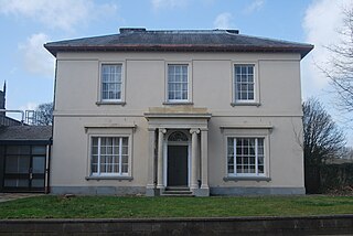
Oak House is a Grade II Listed building on Monk Street Monmouth, Wales.
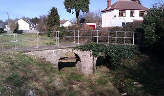
The Clawdd-du, also known in historical records as the Black Dyke, Black Ditch or Clawthy, is a mediaeval linear defensive earthwork or moat, constructed as protection for the faubourg of Overmonnow, on the opposite side of the River Monnow from the town and castle of Monmouth, Wales.

Agincourt Square is an open space in the centre of Monmouth, Wales, in front of the Shire Hall. The area has been used for public functions and markets over the centuries.
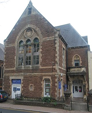
1 Monk Street, Monmouth was built as a Working Men's Free Institute. It is a Grade II Listed building in Monmouth, Wales and located next to Monmouth Baptist Church.

Whitecross Street is a historic street in the town centre of Monmouth, Monmouthshire, Wales. It was in existence by the 15th century, and appears as Whit crose on the 1610 map of the town by cartographer John Speed. It runs in an east-west direction, between Church Street and St James Square. It has been suggested that the street takes its name from a plague cross. Whitecross Street is lined with numerous listed buildings.
Monk Street is an historic street in the town of Monmouth, Monmouthshire, Wales. A portion of it was in existence by the 14th century, and appears on the 1610 map of the town by cartographer John Speed. It runs in a north-south direction, extending northward from its intersection with Whitecross Street. The name of the street relates to the nearby Priory, as well as the gate which was originally on this road and provided part of the town's defences, Monk's Gate. Monk Street is lined with numerous listed buildings.

The Masonic Hall is a grade II listed building on Monk Street in Monmouth, Monmouthshire, Wales. It was designed by architect George Vaughan Maddox. The building is believed to mark the site of Monk's Gate, part of the original defences of the town of Monmouth. Before its 1846 conversion to the Masonic Hall, the building served as the Monk Street Theatre. After more than 150 years of housing the Loyal Monmouth Lodge No. 457, the Masonic Hall sustained fire and smoke damage from suspected arson. The Lodge of Freemasons housed in the building is the oldest surviving Masonic Lodge in Monmouthshire.
Wye Bridge Ward was one of four wards in the town of Monmouth, Monmouthshire, Wales. Streets in the ward included St Mary's Street, Almshouse Street, St James Street, St James Square, Whitecross Street and Monk Street. The ward existed as a division of the town by the early seventeenth century, and continued into the twentieth century.

1–6 Priory Street in Monmouth, Wales, is a row of six shop houses designed by the architect George Vaughan Maddox and constructed c. 1837. They form part of Maddox's redevelopment of the centre of Monmouth and stand opposite his Market Hall. The architectural historian John Newman has written that Maddox's work "gives Monmouth its particular architectural flavour," and considers Priory Street to be "his greatest work."

12–16 Church Street in Monmouth, Wales, is a row of three shop houses designed by the architect George Vaughan Maddox and constructed c. 1837. They form part of Maddox's redevelopment of the centre of Monmouth and stand on Church Street, to the rear of Maddox's Priory Street. The architectural historian John Newman has written that Maddox's work "gives Monmouth its particular architectural flavour" and Cadw describes the grouping of 12–16 Church Street as "the best preserved early 19th century shopfront in Monmouth."


