Church of All Saints, Dulverton

Last updated

Church of All Saints
All Saints, Dulverton, Somerset (2866554658).jpg
Location Dulverton, Somerset, England
Coordinates 51°02′28″N3°32′59″W / 51.0411°N 3.5496°W / 51.0411; -3.5496
Listed Building – Grade II*
Official nameChurch of All Saints
Designated6 April 1959 [1]
Reference no.1247824
Somerset UK location map.svg
Red pog.svg
Location of Church of All Saints in Somerset

The Anglican Church of All Saints in Dulverton, Somerset, England was built in the 15th century and largely rebuilt in the 1850s. It is a Grade II* listed building. [1]

Contents

History

A church was recorded on the site by 1155 when it was squired by the Augustinians of Taunton Priory. [2]

The tower of All Saints Church in Bank Square survives from the 15th-century building; however, the rest of the church was extensively restored between 1853 and 1855 when it was largely rebuilt by Edward Ashworth. [1] [3]

In 2012 the BBC Radio programme Any Questions? was broadcast from the church. [4]

The parish is part of the benefice of Dulverton with Brushford, Brompton Regis, Upton and Withiel Florey within the Diocese of Bath and Wells. [5]

Architecture

The stone building has Hamstone dressings and a slate roof. The nave is of four bays. The three-stage west tower is supported by diagonal buttresses. [1]

The interior of the church includes several tablets memorials and fittings from the church before its restoration including a royal coat of arms from 1714. [1]

The churchyard is accessed via a lychgate from the town. [6]

See also

Related Research Articles

<span class="mw-page-title-main">Dulverton</span> Human settlement in England

Dulverton is a town and civil parish in west Somerset, England, near the border with Devon. The town had a population of 1,408 at the 2011 Census. The parish includes the hamlets of Battleton and Ashwick which is located approximately 4 miles (6.4 km) north west of Dulverton.

<span class="mw-page-title-main">Brompton Regis</span> Human settlement in England

Brompton Regis is a village and civil parish in the Somerset West and Taunton district of Somerset, England about 5 miles (8.0 km) north-east of Dulverton. It is situated on the River Pulham in the Brendon Hills within the Exmoor National Park, close to Wimbleball Lake, a water supply reservoir constructed in the 1970s and completed in 1979. According to the 2011 census the village had a population of 449. The parish boundary is marked by the River Exe which is crossed by the medieval Chilly Bridge and Hele Bridge. The Haddeo is crossed by Bury Bridge.

<span class="mw-page-title-main">Withypool</span> Human settlement in England

Withypool is a small village and former civil parish, now in the parish of Withypool and Hawkridge, in the Somerset district, in the ceremonial county of Somerset, England, near the centre of Exmoor National Park and close to the border with Devon. The word Withy means "willow". The parish of Withypool and Hawkridge, covers 3,097 hectares, includes the village of Hawkridge and has a population around 201.

<span class="mw-page-title-main">Exford, Somerset</span> Human settlement in England

Exford is a rural village at the centre of Exmoor National Park, 7 miles (11 km) north-west of Dulverton, and 10 miles (16 km) south-west of Minehead, in Somerset, England. Less than a mile away is the hamlet of Lyncombe.

<span class="mw-page-title-main">Exton, Somerset</span> Human settlement in England

Exton is a village and civil parish 5 miles (8 km) north-east of Dulverton and 9 miles (14 km) south-west of Dunster in Somerset, England. It lies on the River Exe on Exmoor. The parish includes the village of Bridgetown and covers 2,017 ha, all of which is within the national park.

<span class="mw-page-title-main">Skilgate</span> Human settlement in England

Skilgate is a village and civil parish 5 miles (8 km) east of Dulverton and 8 miles (13 km) west of Wiveliscombe in the Somerset West and Taunton district of Somerset, England. It has a population of 96.

<span class="mw-page-title-main">St Peter's Church, Huish Champflower</span> Church in Somerset, England

The Church of St Peter in Huish Champflower, Somerset, England dates from the 15th century, with the north aisle being built in 1534. It has been designated by English Heritage as a Grade I listed building.

<span class="mw-page-title-main">Church of All Saints, Wootton Courtenay</span> Church in Somerset, England

The Church of All Saints in Wootton Courtenay, Somerset, England, dates from the 13th century and has been designated as a Grade I listed building.

<span class="mw-page-title-main">Church of All Saints, Chipstable</span> Church in Somerset, England

The Church of All Saints is an Anglican church in Chipstable, Somerset, England which probably dates from the early 13th century. It is located in the deanery of Tone, within the diocese of Bath and Wells. It is a Grade II* listed building.

<span class="mw-page-title-main">St Peter's Church, Exton</span> Church in Somerset, England

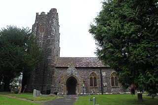
The Anglican St Peter's Church at Exton within the English county of Somerset has a 13th-century tower and 15th century aisle. It is a Grade II* listed building.

<span class="mw-page-title-main">Church of St Bartholomew, Rodhuish</span> Church in Somerset, England

The Anglican Church of St Bartholomew in Rodhuish, Somerset, England was built in the 15th century. It is a Grade II* listed building.

<span class="mw-page-title-main">Church of St Mary, Brompton Regis</span> Church in Somerset, England

The Anglican Church of St Mary in Brompton Regis, Somerset, England was built in the 13th century. It is a Grade II* listed building.

<span class="mw-page-title-main">Church of St John, Cutcombe</span> Church in Somerset, England

The Anglican Church of St John in Cutcombe, Somerset, England was built in the 13th and 14th centuries. It is a Grade II* listed building.

<span class="mw-page-title-main">Church of St Mary Magdelene, Exford</span> 15th-century Anglican church in Somerset, England

The Anglican Church of St Mary Magdelene in Exford, Somerset, England was built in the 15th century. It is a Grade II* listed building.

<span class="mw-page-title-main">Church of St Giles, Hawkridge</span> Church in Somerset, England

The Anglican Church of St Giles in Hawkridge, Somerset, England was built in the 14th century. It is a Grade II* listed building.

<span class="mw-page-title-main">Church of St Mary, Oare</span> Church in Somerset, England

The Anglican Church of St Mary in Oare, Somerset, England, was built in the 15th century. It is a Grade II* listed building.

<span class="mw-page-title-main">Stoke Pero Church</span> Church in Somerset, England

Stoke Pero Church in Stoke Pero, Somerset, England was built in the 13th century. It is a Grade II* listed building. Standing 1,013 feet above sea level, it is the highest church on Exmoor.

<span class="mw-page-title-main">Church of St Andrew, Withypool</span> Church in Withypool, Somerset, UK

The Anglican Church of St Andrew in Withypool, Somerset, England was built in late medieval period. It is a Grade II* listed building.

<span class="mw-page-title-main">Church of St John, Skilgate</span> Church in Somerset, England

The Anglican Church of St John in Skilgate, Somerset, England was built in the 14th century. It is a Grade II* listed building.

<span class="mw-page-title-main">Church of St Mary Magdalene, Withiel Florey</span> Church in Somerset, England

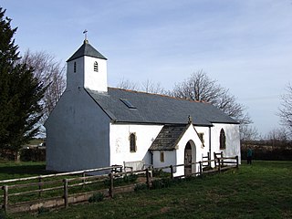
The Anglican Church of St Mary Magdalene in Withiel Florey, Somerset, England was built in the 12th century. It is a Grade II* listed building.

References

  1. 1 2 3 4 5 "Church of All Saints". National Heritage List for England. Historic England. Retrieved 28 August 2017.
  2. "MSO9327 - Church of All Saints and Graveyard, Dulverton". Exmoor Historic Environment Record. Exmoor National Park. Retrieved 28 August 2017.
  3. "Dulverton Church". Victoria County History. Retrieved 28 August 2017.
  4. "All Saints Church, Dulverton, Somerset". Any Questions?. BBC. Retrieved 28 August 2017.
  5. "All Saints, Dulverton". A Church Near You. Church of England. Retrieved 28 August 2017.
  6. "Dulverton Conservation Area: Appraisal Document" (PDF). Exmoor National Park. p. 49. Archived from the original (PDF) on 29 August 2017. Retrieved 28 August 2017.