| Church of All Saints | |
|---|---|
 | |
Listed Building – Grade II* | |
| Official name | Church of All Saints |
| Designated | 31 May 1954 |
| Reference no. | 1083559 |
The Church of All Saints is a Grade II* listed church in Orpington, Bromley, London. [1] [2]
| Church of All Saints | |
|---|---|
| | |
Listed Building – Grade II* | |
| Official name | Church of All Saints |
| Designated | 31 May 1954 |
| Reference no. | 1083559 |
The Church of All Saints is a Grade II* listed church in Orpington, Bromley, London. [1] [2]
The old part of the church dates back to the Anglo-Saxon period in 1070. In 1957, a new church was built according to the design of Geddes Hislop, and the extensively renovated old church became an annex of the new church. [3]


Beckenham is a town in Greater London, England, within the London Borough of Bromley. Until 1965 it was part of the historic county of Kent. It is located 8.4 miles (13.5 km) south-east of Charing Cross, situated north of Elmers End and Eden Park, east of Penge, south of Lower Sydenham and Bellingham, and west of Bromley and Shortlands. Its population at the 2011 census counted 46,844 inhabitants.

Biggin Hill is a town in South East London, England, within the London Borough of Bromley. It is situated beyond London's urban sprawl in the Metropolitan green belt, 15.2 miles (24.5 km) south-southeast of Charing Cross. It is located adjacent to the boundaries of Greater London, Kent and Surrey. Prior to the creation of Greater London in 1965, it was in the historic and administrative county of Kent. At the 2011 Census, Biggin Hill had a population of 9,951.

Chislehurst is a suburban district of south-east London, England, in the London Borough of Bromley. It lies east of Bromley, south-west of Sidcup and north-west of Orpington, 10 miles (16 km) south-east of Charing Cross. Before the creation of Greater London in 1965, it was in Kent.

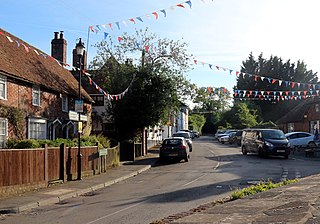
Keston is a village in Greater London, England, located within the London Borough of Bromley, Greater London. Prior to 1965 it was within the historic county of Kent. It is part suburban, part rural in nature and lies on the edge of Hayes Common, just beyond the London conurbation to the south of Bromley Common. It includes the small hamlet of Nash to the southwest. The northern, more suburban part of Keston is sometimes referred to as Keston Mark.

Orpington is a town and area in south east London, England, within the London Borough of Bromley. It is 13.4 miles south east of Charing Cross.
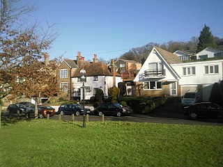
Pratt's Bottom is a village in Greater London, England, within the London Borough of Bromley and, prior to 1965, within the historic county of Kent. It is south of its parent parish of Orpington, lies about 100 metres above sea level and beyond London's urban sprawl.
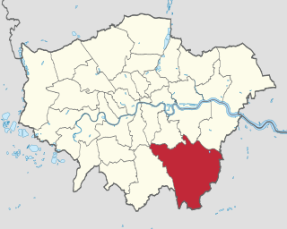
The London Borough of Bromley is the largest and southeasternmost of the London boroughs that make up Greater London, bordering the ceremonial county of Kent, which most of Bromley was part of before 1965. The borough's population is an estimated 332,336. It is named after Bromley, its principal town; other major towns are Penge, Hayes, West Wickham, Chislehurst, Beckenham and Orpington. The local authority is Bromley London Borough Council.

Beckenham is a constituency represented in the House of Commons of the Parliament of the United Kingdom since 2010 by Bob Stewart, a Conservative.

Bromley and Chislehurst is a constituency represented in the House of Commons of the Parliament of the United Kingdom since 2006 by Bob Neill, a Conservative.

Poplar was a local government district in the metropolitan area of London, England. It was formed as a district of the Metropolis in 1855 and became a metropolitan borough in the County of London in 1900. It comprised Poplar, Millwall, Bromley-by-Bow and Bow as well as Old Ford, Fish Island and Cubitt Town.
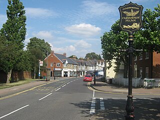
Farnborough is a village in south-eastern Greater London, England, and prior to 1965, in the historic county of Kent. Situated south of Locksbottom, west of Green Street Green, north of Downe and Hazelwood, and east of Keston, it is centred 13.4 miles (21.6 km) southeast of Charing Cross.
Halstead is a village and civil parish in the Sevenoaks District of Kent, England. It is located 4.7 miles south east of Orpington & 6.1 miles north west of Sevenoaks, adjacent to the Kent border with Greater London. The population of the civil parish at the 2011 census was 1,607.

Orpington is a constituency created in 1945 and represented in the House of Commons of the UK Parliament since 2019 by Gareth Bacon, a Conservative. It is the largest constituency in Greater London by area, covering the east and south of the London Borough of Bromley.
Knockholt is a village and civil parish in the Sevenoaks District of Kent, England. It is located 5 mi (8 km) north west of Sevenoaks & 5.7 mi (9.2 km) south of Orpington, adjacent to the Kent border with Greater London.
Orpington was an English local government district in northwest Kent from 1934 to 1965 around the town of Orpington. It was a suburb of London and formed part of the Metropolitan Police District. Most of the former area of the urban district is now part of the London Borough of Bromley in Greater London.
Bromley was a rural district in north-west Kent, England from 1894 to 1934. Its area now forms part of the London Borough of Bromley in Greater London. It did not include the main settlement of the same name, which constituted the Municipal Borough of Bromley. Mottingham formed an exclave of the district.
Ruxley is a rural settlement of South East London, England that straddles the boundary of the London Boroughs of Bromley and Bexley. It is located 13 miles southeast of Charing Cross, the traditional centre of London, in the Metropolitan Green Belt between Sidcup and Swanley and is also adjacent to the Greater London border with the county of Kent.
Chelsfield is an area in south-east London, England, within the London Borough of Bromley and, prior to 1965, in the historic county of Kent. It lies south of Goddington, west of Well Hill, north of Pratt's Bottom and east of Green Street Green. The area is split into two distinct areas – the historic 'village' section, and the newer development by the train station.

High Elms Country Park is an extensive 250-acre (100 ha) public park on the North Downs in Farnborough in the London Borough of Bromley. It is a Local Nature Reserve, and together with the neighbouring Downe Bank, a Site of Special Scientific Interest. The park surrounds High Elms Golf Course, and has extensive woodland, chiefly oak and beech, chalk meadows and formal gardens. It also has a cafe, a visitor centre, nature and history trails and car parks.