Church of Our Lady Help of Christians (Staten Island, New York)

Last updated
The Church of Our Lady Help of Christians
Our Lady Help of Christians Church, Staten Island, New York.jpg
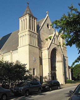
The old church building as it appeared in 1914
Location Tottenville, Staten Island, New York
Country United States of America
Website http://olhcparish.org
Administration
Archdiocese New York

The Church of Our Lady Help of Christians is a parish church under the authority of the Roman Catholic Archdiocese of New York, located in Tottenville, Staten Island, New York City. The church was established in 1890 as a mission of St. Joseph's Church (Rossville) and became an independent parish in 1898. Its first church building was constructed later that year. It burned down in 1985 and was rebuilt in 1990. [1] [2]

Roman Catholic Archdiocese of New York Archdiocese of the Catholic Church

The Roman CatholicArchdiocese of New York is a Latin Catholic archdiocese in New York State. It encompasses the boroughs of Manhattan, the Bronx and Staten Island in New York City and the counties of Dutchess, Orange, Putnam, Rockland, Sullivan, Ulster, and Westchester in New York. The Archdiocese of New York is the second-largest diocese in the United States, encompassing 296 parishes that serve around 2.8 million Catholics in addition to hundreds of Catholic schools, hospitals and charities. The Archdiocese also operates the well-known St. Joseph's Seminary, commonly referred to as Dunwoodie. The Archdiocese of New York is the metropolitan see of the ecclesiastical province of New York which includes the suffragan dioceses of Albany, Brooklyn, Buffalo, Ogdensburg, Rochester, Rockville Centre and Syracuse.

Tottenville, Staten Island Neighborhood of Staten Island in New York City

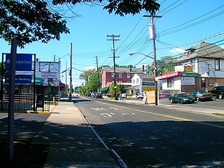
Tottenville is a neighborhood on the South Shore of Staten Island, New York City. It is the southernmost settlement in both New York City and New York State. Tottenville is bounded on three sides by water: the south side abuts New York Bight while the west and north sides are bordered by Arthur Kill and the New Jersey state border. The eastern boundary is formed by Richmond Valley Road and Richard Avenue.

New York City Largest city in the United States

The City of New York, usually called either New York City (NYC) or simply New York (NY), is the most populous city in the United States. With an estimated 2017 population of 8,622,698 distributed over a land area of about 302.6 square miles (784 km2), New York is also the most densely populated major city in the United States. Located at the southern tip of the state of New York, the city is the center of the New York metropolitan area, the largest metropolitan area in the world by urban landmass and one of the world's most populous megacities, with an estimated 20,320,876 people in its 2017 Metropolitan Statistical Area and 23,876,155 residents in its Combined Statistical Area. A global power city, New York City has been described as the cultural, financial, and media capital of the world, and exerts a significant impact upon commerce, entertainment, research, technology, education, politics, tourism, art, fashion, and sports. The city's fast pace has inspired the term New York minute. Home to the headquarters of the United Nations, New York is an important center for international diplomacy.

Related Research Articles

Huguenot, Staten Island

Huguenot is the name of a neighborhood located on the South Shore of Staten Island, New York City. Originally named "Bloomingview", its present name is derived from the Huguenots, led by Daniel Perrin, who settled in the area during the late 17th and early 18th centuries to escape religious persecution.

Richmond Valley, Staten Island neighborhood on Staten Island

Richmond Valley is the name of a neighborhood located on the South Shore of Staten Island, one of the five boroughs of New York City, the largest city in the United States. Richmond Valley is bordered on the north by Pleasant Plains, to the south by Tottenville, to the west by the Arthur Kill, and to the east by the Lower New York Bay.

Rosebank, Staten Island neighborhood in the northeastern part of Staten Island

Rosebank is a neighborhood in the northeastern part of Staten Island, one of the five boroughs of New York City. It is bordered by Clifton to the north, Arrochar to the south, and the Upper New York Bay to the east.

Bulls Head is a neighborhood in west-central Staten Island, one of the five boroughs of New York City. It is bordered by New Springville to the south, Bloomfield to the west, Willowbrook to the east, Graniteville to the north, and Westerleigh to the north.

St. Marys Church (Staten Island)

The Church of St. Mary is a Roman Catholic parish church in the Roman Catholic Archdiocese of New York, located at 1101 Bay Street, Staten Island, New York City. St. Mary's is the second oldest of the 36 Roman Catholic parishes on Staten Island, having been established in 1852, after St. Peter's (1839), and before St. Joseph's (1855).

The Church of Our Lady of Good Counsel is a Roman Catholic parish church in the Roman Catholic Archdiocese of New York, located at 10 Austin Place, Staten Island, New York City.

Church of Our Lady Queen of Peace (Staten Island, New York) New York

The Church of Our Lady Queen of Peace is a parish church in the Roman Catholic Archdiocese of New York, located at 90 Third Street in the New Dorp neighborhood of Staten Island, New York City. It was established on October 10, 1922, and the present church building was inaugurated on Christmas Eve, 1928.

The Church of Our Lady Star of the Sea is a Roman Catholic parish church in the Roman Catholic Archdiocese of New York, located at 5371 Amboy Road, Staten Island, New York City. It was established in 1935 as a former mission of Our Lady Help of Christians.

The Church of St. Charles is a parish church in the Roman Catholic Archdiocese of New York, currently located at 644 Clawson Street in the Oakwood neighborhood of Staten Island, New York City.

The Church of St. Roch is a Roman Catholic parish church in the Roman Catholic Archdiocese of New York, located at 602 Port Richmond Avenue, Staten Island, New York City. It was established in 1922. It is sometimes confused with St. Roch's Church St. in the Bronx, which was established in 1899.

The Church of the Blessed Sacrament is a Roman Catholic parish church in the Roman Catholic Archdiocese of New York, located at Forest Avenue at Manor Road, Staten Island, New York City, in the neighborhood of West New Brighton, Staten Island. The parish was established in 1910.

St. Patricks Church (Staten Island, New York) church building in New York, United States of America

The Church of St. Patrick is a parish church under the authority of the Roman Catholic Archdiocese of New York, located in the Richmondtown area of Staten Island, New York City.

St. Rita's Church is a Roman Catholic-parish church governed by the Roman Catholic Archdiocese of New York, in Staten Island, New York City. There was a St. Rita of Cascia's Church established in 1900.

St. Peters Church (Staten Island, New York) church building in New York, United States of America

The Church of St. Peter is a parish church under the authority of the Roman Catholic Archdiocese of New York, located in Staten Island, New York City in the neighborhood of New Brighton. St. Peter's is the oldest of the 36 Roman Catholic parishes on Staten Island, having been established in 1839, before the second-oldest St. Mary's (1852) and the third-oldest St. Joseph's (1855).

Church of Our Lady of Pity (Staten Island, New York) church building in New York, United States of America

The Church of Our Lady of Pity is a Roman Catholic parish church under the authority of the Roman Catholic Archdiocese of New York, located in Staten Island, New York City. The church is located at 1616 Richmond Avenue, just south of the Staten Island Expressway.

Church of the Holy Family (Staten Island, New York) church building in New York, United States of America

The Church of the Holy Family is a Roman Catholic parish church under the authority of the Roman Catholic Archdiocese of New York, located in Staten Island, New York City. The parish was founded in 1966 and is located at 366 Watchogue Road Westerleigh, Staten Island.

The Church St. Adalbert is a parish church under the authority of the Roman Catholic Archdiocese of New York, located in Staten Island, New York City. The parish was established in 1901.

Augustinian Academy (Staten Island)

The Augustinian Academy on Staten Island, New York, was founded on May 30, 1899, in conjunction with the new Roman Catholic parish of Our Lady of Good Counsel, both by the Augustinian Friars. The buildings were originally erected for the Visitation Sisters, and were purchased and modified by the Augustinians for educational purposes. The academy buildings were dedicated by Bishop Sebastiano Martinelli on September 10, 1899, and officially opened on September 13, 1899, as "The Catholic High School of Richmond Borough". This was the first Catholic settlement in Tompkinsville, and the first Mass was said in the neighborhood on November 12, 1899, in McRobert's Hall on Arietta Street. Our Lady of Good Counsel occupied the large chapel in the academy building, along with the small chapel of Our Lady of Consolation, erected in 1902 on St. Paul's Avenue.

The Church of St. Joseph is a Roman Catholic parish church in the Roman Catholic Archdiocese of New York, and the oldest extant Roman Catholic church on Staten Island. The nearby cemetery is the second-oldest Roman Catholic cemetery on the island. The church is located on Poplar Avenue in Rossville, Staten Island, New York City, New York.

References

  1. "History". Our Lady Help of Christians. Retrieved April 9, 2019.
  2. Lore, Diane C. (March 3, 2016). "Vintage photos, facts about Staten Island churches". Staten Island Advance. Retrieved July 26, 2017.

Coordinates: 40°30′35.26″N74°14′36.41″W / 40.5097944°N 74.2434472°W / 40.5097944; -74.2434472

Geographic coordinate system Coordinate system

A geographic coordinate system is a coordinate system that enables every location on Earth to be specified by a set of numbers, letters or symbols. The coordinates are often chosen such that one of the numbers represents a vertical position and two or three of the numbers represent a horizontal position; alternatively, a geographic position may be expressed in a combined three-dimensional Cartesian vector. A common choice of coordinates is latitude, longitude and elevation. To specify a location on a plane requires a map projection.