Church of St Peter and St Paul, Heytesbury

Last updated

St Peter and St Paul, Heytesbury
Church of St Peter and St Paul
Church of St. Peter and St. Paul (geograph 1946840).jpg
Wiltshire UK location map.svg
Red pog.svg
St Peter and St Paul, Heytesbury
Location in Wiltshire
51°10′56″N2°06′31″W / 51.1823°N 2.1086°W / 51.1823; -2.1086
OS grid reference ST925426
LocationHeytesbury, Wiltshire
CountryEngland
Denomination Anglican
Website www.upperwylyevalleyteam.com/our-churches/st-peter-st-paul-heytesbury/
History
Status Parish church
Architecture
Functional statusActive
Years built13th century, restored 1864-7
Administration
Province Canterbury
Diocese Salisbury
Archdeaconry Sarum
Deanery Heytesbury
Parish Heytesbury with Tytherington and Knook
Listed Building – Grade I
Reference no.1036357 [1]

The Church of St Peter and St Paul, Heytesbury is the Church of England parish church for the parish of Heytesbury with Tytherington and Knook, Wiltshire, England. It was a collegiate church from the 12th century until 1840. The present building is largely 13th-century and is designated as Grade I listed.

Contents

History

A church was mentioned at Hestrebe in the Domesday Book of 1086. [2] The church was given to Salisbury Cathedral by Henry I in about 1115, together with the church of Godalming, Surrey, and lands lying beside the two churches, to form a prebend. Shortly after this the church became collegiate, with the head of the college the canon who held the prebend at the cathedral. [3]

A charter granted by bishop Josceline (or Jocelin) between 1150 and 1160 established four canons at Heytesbury. Their income included tithes from Tytherington, where there was a chapel, and from Horningsham; the churches of Hill Deverill and Swallowcliffe; and land at Wilton. [3] From about 1220 the prebend of Heytesbury was annexed to the deanery of Salisbury, thus the Dean of Salisbury was also Dean of Heytesbury. [3] Most collegiate churches were abolished in 1547 as part of the Reformation but Heytesbury continued until it was suppressed, along with the other remaining non-residential deaneries, by the Ecclesiastical Commissioners Act 1840. [4]

Architecture and interior

The large cruciform church dates from the 13th century, although a fragment of earlier work survives: one pier of the north aisle, with a scalloped capital, is partly from the late 12th century. [5]

The low tower over the crossing was completed in the 14th century [1] and the clerestory was added in the mid-15th. [6]

The south chapel, founded c. 1316, is dedicated to St Catherine. [7] In the north transept, Walter Hungerford founded a chapel in 1421; [7] the 16th-century stone screen survives. [1]

The tower has six bells: the tenor is from c. 1460, alongside two from the 17th century and two from the 18th. [8]

The vestry and the gabled south porch are from the 19th century. Restoration in 1864-7 was by William Butterfield and included rebuilding of the north and south aisles; interior work included the addition of a coloured marble font in the south aisle, new pews, a polychrome tiled floor, and stained glass by Alexander Gibbs. [1] Pevsner criticised the restoration, describing the buildings as "A large and impressive church, but an over-restored one [...] which makes it externally more rewarding from a distance than from near by and internally disappointing in spite of its undeniable grandeur". However, he added that "Most of the glass of Butterfield's restoration is good and characteristic. Pale colours, good leading." [9]

The organ was installed in 1854 by J.W. Walker, having been moved from St Mary's, Bermondsey, London. It was taken down during Butterfield's restoration and reconstructed in 1867 in a new position, with new case fronts in deal. [10] [6]

The building was designated as Grade I listed in 1968. [1]

Parish

Dependent churches and chapels of Heytesbury were those nearby at Tytherington, Knook, Hill Deverill, Horningsham, and the more distant church at Swallowcliffe, some 10 miles (16 km) to the south. [3]

In 1885 the benefice of Heytesbury-with-Tytherington was united with Knook, [11] and this union was reaffirmed in 1970. [12] In 1976 the parishes of Sutton Veny and Norton Bavant were added. [13] Since 2000 [7] the church has been served by the Upper Wylye Valley team. [6] Currently, the position of Team Rector is vacant, as is the position of Vicar following the departure of Rev'd. Clifford Stride in February 2024. [14]

Parish registers survive from 1653 and are held by the Wiltshire and Swindon History Centre at Chippenham. [7]

Related Research Articles

<span class="mw-page-title-main">William Butterfield</span> British architect

William Butterfield was a British Gothic Revival architect and associated with the Oxford Movement. He is noted for his use of polychromy.

<span class="mw-page-title-main">Imber</span> Human settlement in England

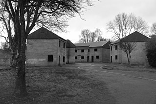
Imber is an uninhabited village and former civil parish within the British Army's training area, now in the parish of Heytesbury, on Salisbury Plain, Wiltshire, England. It lies in an isolated area of the Plain, about 2+12 miles (4 km) west of the A360 road between Tilshead and West Lavington. A linear village, its main street follows the course of a stream.

<span class="mw-page-title-main">Heytesbury</span> Human settlement in England

Heytesbury is a village and a civil parish in Wiltshire, England. The village lies on the north bank of the Wylye, about 3+12 miles (5.6 km) southeast of the town of Warminster.

<span class="mw-page-title-main">Boyton, Wiltshire</span> Human settlement in England

Boyton is a village and civil parish in Wiltshire, England. It lies in the Wylye Valley within Salisbury Plain, about 6 miles (10 km) south-east of Warminster and 13 miles (21 km) north-west of Salisbury. The parish includes the village of Corton.

<span class="mw-page-title-main">River Wylye</span> River in Wiltshire, England

The River Wylye is a chalk stream in the south of England, with clear water flowing over gravel. It is popular with anglers for fly fishing. A half-mile stretch of the river and three lakes in Warminster are a local nature reserve.

<span class="mw-page-title-main">Wylye</span> Human settlement in England

Wylye is a village and civil parish on the River Wylye in Wiltshire, England. The village is about 9+12 miles (15 km) northwest of Salisbury and a similar distance southeast of Warminster.

<span class="mw-page-title-main">Upton Lovell</span> Human settlement in England

Upton Lovell is a village and civil parish in Wiltshire, England. It lies on the A36, in the Wylye valley about 5 miles (8.0 km) southeast of Warminster. The parish is on the left (northeast) bank of the river, and stretches for over two miles northeast onto Salisbury Plain.

<span class="mw-page-title-main">Swallowcliffe</span> Human settlement in England

Swallowcliffe is a small village and civil parish in Wiltshire, England, about 2 miles (3.2 km) southeast of Tisbury and 11 miles (18 km) west of Salisbury. The village lies about half a mile north of the A30 Shaftesbury-Wilton road which crosses the parish.

<span class="mw-page-title-main">Horningsham</span> Human settlement in England

Horningsham is a small village and civil parish in Wiltshire, England, on the county border with Somerset. The village lies about 4 miles (6 km) southwest of the town of Warminster and 4+12 miles (7 km) southeast of Frome, Somerset.

<span class="mw-page-title-main">Norton Bavant</span> Human settlement in England

Norton Bavant is a small village and civil parish in Wiltshire, England, 2 miles (3.2 km) southeast of Warminster.

<span class="mw-page-title-main">Stockton, Wiltshire</span> Human settlement in England

Stockton is a small village and civil parish in the Wylye Valley in Wiltshire, England, about 8 miles (13 km) southeast of Warminster. The parish includes the hamlet of Bapton.

<span class="mw-page-title-main">Longbridge Deverill</span> Human settlement in England

Longbridge Deverill is a village and civil parish about 2.5 miles (4.0 km) south of Warminster in Wiltshire, England. It is on the A350 primary route which connects the M4 motorway and west Wiltshire with Poole, Dorset.

<span class="mw-page-title-main">Brixton Deverill</span> Human settlement in England

Brixton Deverill is a small village and civil parish about 4 miles (6.4 km) south of Warminster in Wiltshire, England.

<span class="mw-page-title-main">Sutton Veny</span> Human settlement in England

Sutton Veny is a village and civil parish in the Wylye valley, to the southeast of the town of Warminster in Wiltshire, England; the village is about 3 miles (5 km) from Warminster town centre. 'Sutton' means 'south farmstead' in relation to Norton Bavant, one mile (1.6 km) to the north. 'Veny' may be a French family name or may describe the village's fenny situation.

<span class="mw-page-title-main">Knook</span> Human settlement in England

Knook is a small village and civil parish in Wiltshire, England. The village lies to the north of the River Wylye at the edge of Salisbury Plain, about 4+12 miles (7 km) southeast of Warminster, close to the A36 road to Salisbury.

<span class="mw-page-title-main">Stapleford, Wiltshire</span> Human settlement in England

Stapleford is a village and civil parish about 4 miles (6.4 km) north of Wilton, Wiltshire, England. The village is on the River Till just above its confluence with the River Wylye.

<span class="mw-page-title-main">Monkton Deverill</span> Human settlement in England

Monkton Deverill is a village and former civil parish, now in the parish of Kingston Deverill, in Wiltshire, England, about five miles south of Warminster and four miles north-east of Mere. The area has been part of Kingston Deverill parish since 1934. It lies on the River Wylye and forms part of a group of villages known as the Upper Deverills. In 1931 the parish had a population of 108.

<span class="mw-page-title-main">Kingston Deverill</span> Human settlement in England

Kingston Deverill is a village and civil parish in Wiltshire, England. Its nearest towns are Mere, about 3+12 miles (6 km) to the southwest, and Warminster, about 5 miles (8 km) to the northeast. The parish and its demographic figures include the village of Monkton Deverill.

<span class="mw-page-title-main">Tytherington, Wiltshire</span> Human settlement in England

Tytherington is a small village in Wiltshire, in the southwest of England. It lies on the south side of the Wylye valley, about 3+12 miles (6 km) southeast of the town of Warminster and 1 mile (1.6 km) southwest of the larger village of Heytesbury. Most of the village is now part of the civil parish of Heytesbury although a few houses in the west are within the parish of Sutton Veny.

References

  1. 1 2 3 4 5 Historic England. "Church of St Peter and St Paul (1036357)". National Heritage List for England . Retrieved 5 March 2017.
  2. Heytesbury in the Domesday Book
  3. 1 2 3 4 Pugh, R.B.; Crittall, Elizabeth (eds.). "Victoria County History: Wiltshire: Vol 3 pp389-392 - Colleges: St Peter & St Paul, Heytesbury". British History Online. University of London. Retrieved 5 March 2017.
  4. "Ecclesiastical Commissioners Act 1840". legislation.gov.uk. Retrieved 5 March 2017.
  5. "SS Peter and Paul, Heytesbury". Corpus of Romanesque Sculpture. King's College London. Retrieved 5 March 2017.
  6. 1 2 3 "Church of St Peter and St Paul Heytesbury". The Upper Wylye Valley Team. Retrieved 14 April 2020.
  7. 1 2 3 4 "Church of St. Peter and St. Paul, Heytesbury". Wiltshire Community History. Wiltshire Council. Retrieved 5 March 2017.
  8. "Heytesbury". Dove's Guide for Church Bell Ringers. Retrieved 5 March 2017.
  9. Pevsner, Nikolaus; Cherry, Bridget (revision) (1975) [1963]. Wiltshire. The Buildings of England (2nd ed.). Harmondsworth: Penguin Books. pp. 266–267. ISBN   0-14-0710-26-4.
  10. "Wiltshire Heytesbury, St. Peter and St. Paul [N08544]". National Pipe Organ Register . British Institute of Organ Studies . Retrieved 5 March 2017.
  11. "No. 25450". The London Gazette . 10 March 1885. p. 1070.
  12. "No. 45204". The London Gazette . 2 October 1970. p. 10763.
  13. "No. 46858". The London Gazette . 25 March 1976. p. 4439.
  14. "Final Farewell to Rev'd Clifford Stride". Upper Wylye Valley Team. Upper Wylye Valley Team. Retrieved 31 March 2024.

Commons-logo.svg Media related to St Peter and St Paul's church, Heytesbury at Wikimedia Commons