Churchill Falls, Newfoundland and Labrador

Last updated

Churchill Falls
Community
Churchill fallslabrador.jpg
Canada Newfoundland and Labrador location map 2.svg
Red pog.svg
Churchill Falls
Coordinates: 53°31′54″N64°00′30″W / 53.53167°N 64.00833°W / 53.53167; -64.00833 Coordinates: 53°31′54″N64°00′30″W / 53.53167°N 64.00833°W / 53.53167; -64.00833
CountryCanada
Province Newfoundland and Labrador
Census division 10
Settled1967
Government
   MHA Perry Trimper
   MP Yvonne Jones
Population
 (2021)
  Total732
Time zone UTC-4 (AST)
  Summer (DST) UTC-3 (ADT)
Area code 709
Highways NL Route 500.svg Route 500 (Trans-Labrador Highway)
Website Official website

Churchill Falls is a community in the province of Newfoundland and Labrador, Canada. It is home to the Churchill Falls Generating Station and is a company town.

Contents

History

John McLean is believed to have been the first European to see the falls in 1839. In 1967, work on the generating station had commenced, officially inaugurated by Premier Joey Smallwood, while residential facilities also began that year. The town was built around a town complex, the Donald Gordon Centre, with amenities such as a school, gymnasium, grocery store, hotel, restaurant, library, curling club and swimming pool. Permanent housing facilities were constructed in 1969. The town is managed and operated by Nalcor Energy and remains a company town to this date. [1]

Transportation

Churchill Falls is connected by the Trans-Labrador Highway with Labrador City and Baie-Comeau in Quebec, its main transportation link. [2]

The Churchill Falls Airport has served the community as a privately-owned airport since 1971. There is no formal terminal building, just a few small structures and the runway. There were scheduled flights to Goose Bay and Wabush in the 1970s, and scheduled service by PAL Airlines (formerly Provincial Airlines) up to 2003. [3]

Geography

Churchill Falls lies on the Churchill River near the Churchill Falls, one of the largest waterfalls in Canada. It is about 245 km (152 mi) east of Labrador City. [4]

Climate

Under the Köppen climate classification, Churchill Falls has a subarctic climate (Dfc) with long, cold winters and short, mild summers.

Climate data for Churchill Falls Airport (1961−1990)
MonthJanFebMarAprMayJunJulAugSepOctNovDecYear
Record high °C (°F)6.9
(44.4)
16.6
(61.9)
12.4
(54.3)
15.6
(60.1)
26.0
(78.8)
33.4
(92.1)
31.1
(88.0)
30.3
(86.5)
27.1
(80.8)
21.7
(71.1)
13.1
(55.6)
7.2
(45.0)
33.4
(92.1)
Average high °C (°F)−15.9
(3.4)
−13.4
(7.9)
−6.8
(19.8)
0.6
(33.1)
8.1
(46.6)
15.0
(59.0)
19.0
(66.2)
17.2
(63.0)
10.4
(50.7)
2.9
(37.2)
−4.2
(24.4)
−13.5
(7.7)
1.6
(34.9)
Daily mean °C (°F)−21.5
(−6.7)
−19.7
(−3.5)
−13.2
(8.2)
−5.0
(23.0)
3.0
(37.4)
9.5
(49.1)
13.7
(56.7)
12.2
(54.0)
6.4
(43.5)
−0.4
(31.3)
−8.2
(17.2)
−18.5
(−1.3)
−3.5
(25.7)
Average low °C (°F)−27.3
(−17.1)
−26.1
(−15.0)
−19.7
(−3.5)
−10.8
(12.6)
−2.2
(28.0)
4.0
(39.2)
8.4
(47.1)
7.2
(45.0)
2.3
(36.1)
−3.9
(25.0)
−12.4
(9.7)
−23.6
(−10.5)
−8.7
(16.3)
Record low °C (°F)−43.3
(−45.9)
−45.6
(−50.1)
−38.3
(−36.9)
−30
(−22)
−22.8
(−9.0)
−5.4
(22.3)
0.9
(33.6)
−0.6
(30.9)
−7
(19)
−19.4
(−2.9)
−31.3
(−24.3)
−40.6
(−41.1)
−45.6
(−50.1)
Average precipitation mm (inches)64.4
(2.54)
51.4
(2.02)
62.8
(2.47)
66.0
(2.60)
56.8
(2.24)
94.7
(3.73)
114.0
(4.49)
93.1
(3.67)
110.6
(4.35)
80.7
(3.18)
82.0
(3.23)
68.2
(2.69)
944.7
(37.19)
Average rainfall mm (inches)0.8
(0.03)
1.9
(0.07)
3.7
(0.15)
10.5
(0.41)
36.3
(1.43)
87.8
(3.46)
114.0
(4.49)
93.0
(3.66)
98.2
(3.87)
37.7
(1.48)
10.6
(0.42)
3.4
(0.13)
497.9
(19.60)
Average snowfall cm (inches)71.6
(28.2)
55.8
(22.0)
64.7
(25.5)
57.5
(22.6)
20.2
(8.0)
6.5
(2.6)
0.0
(0.0)
0.0
(0.0)
11.9
(4.7)
44.0
(17.3)
76.8
(30.2)
72.1
(28.4)
481.0
(189.4)
Average precipitation days (≥ 0.2 mm)181516161517191920202120216
Average rainy days (≥ 0.2 mm)00241016191918931102
Average snowy days (≥ 0.2 cm)1815161472005151920132
Mean monthly sunshine hours 98.7127.0141.8161.9201.4193.5206.2184.8100.769.954.478.01,618.4
Percent possible sunshine 39463939413840402621213336
Source 1: Environment Canada [5]
Source 2: NOAA (percent sun) [6]

Demographics

Historical populations
YearPop.±%
2006 681    
2011 634−6.9%
2016 705+11.2%
2021 732+3.8%
[7]

Churchill Falls is a part of the Division No. 10, Subdivision D. As of the 2021 census, it had a population of 732. There were a total of 556 private dwellings. The population was spread out, with 175 being from age 0 to 14, 535 from age 15 to 64, and 20 being age 65 or older. The average age was 34.0. English was the mother tongue of 705 residents, while French was the mother tongue of the remaining 15. A total of 60 residents claimed to be of First Nations heritage, while 40 were Métis. [7]

Sports and recreation

The Terry Smith Memorial Arena, named after a longtime resident, is one of the most popular facilities in town. The Churchill Falls Gymnasium serves the needs of the Eric G. Lambert School as well as badminton and hockey teams. The curling club is based at the Donald Gordon Center. There are also soccer fields and a swimming pool in the community. [8]

See also

Related Research Articles

<span class="mw-page-title-main">Labrador</span> Mainland portion of Newfoundland and Labrador

Labrador is a geographic and cultural region within the Canadian province of Newfoundland and Labrador. It is the primarily continental portion of the province and constitutes 71% of the province's area but is home to only 6% of its population. It is separated from the island of Newfoundland by the Strait of Belle Isle. It is the largest and northernmost geographical region in the four Atlantic provinces.

<span class="mw-page-title-main">St. John's, Newfoundland and Labrador</span> Capital and largest city of Newfoundland and Labrador, Canada

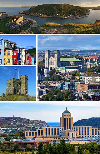
St. John's is the capital and largest city of the Canadian province of Newfoundland and Labrador, located on the eastern tip of the Avalon Peninsula on the island of Newfoundland.

Clarenville is a town on the east coast of Newfoundland in the province of Newfoundland and Labrador, Canada. Clarenville was incorporated in 1951. It is located in the Shoal Harbour valley, fronting an arm of the Atlantic Ocean called Random Sound.

Grand Falls-Windsor is a town located in the central region of the island of Newfoundland in the province of Newfoundland and Labrador, Canada, with a population of 13,853 at the 2021 census. The town is the largest in the central region, the sixth largest in the province, and is home to the annual Exploits Valley Salmon Festival. Grand Falls-Windsor was incorporated in 1991, when the two former towns of Grand Falls and Windsor amalgamated.

<span class="mw-page-title-main">Stephenville, Newfoundland and Labrador</span> Town in Newfoundland and Labrador, Canada

Stephenville is a town in Newfoundland and Labrador, Canada, on the west coast of the island of Newfoundland.

<span class="mw-page-title-main">Deer Lake, Newfoundland and Labrador</span> Town in Newfoundland and Labrador, Canada

Deer Lake is a town in the western part of the island of Newfoundland in the province of Newfoundland and Labrador, Canada.

<span class="mw-page-title-main">Channel-Port aux Basques</span> Town in Newfoundland and Labrador, Canada

Channel-Port aux Basques is a town at the extreme southwestern tip of Newfoundland fronting on the western end of the Cabot Strait. A Marine Atlantic ferry terminal is located in the town which is the primary entry point onto the island of Newfoundland and the western terminus of the Newfoundland and Labrador Route 1 in the province. The town was incorporated in 1945 and its population in the 2021 census was 3,547.

<span class="mw-page-title-main">Nain, Newfoundland and Labrador</span> Inuit community in Newfoundland and Labrador, Canada

Nain is the northernmost permanent settlement in the Canadian province of Newfoundland and Labrador, within the Nunatsiavut region, located about 370 km (230 mi) by air from Happy Valley-Goose Bay. The town was established as a Moravian mission in 1771 by Jens Haven and other missionaries. As of 2021, the population is 1,204 mostly Inuit and mixed Inuit-European. Nain is the administrative capital of the autonomous region of Nunatsiavut.

<span class="mw-page-title-main">Botwood</span> Town in Newfoundland and Labrador, Canada

Botwood is a town in north-central Newfoundland, Newfoundland and Labrador, Canada in Census Division 6. It is located on the west shore of the Bay of Exploits on a natural deep water harbour used by cargo ships and seaplanes throughout the town's history. Botwood was the North American terminus for the first transatlantic commercial flights.

<span class="mw-page-title-main">Conception Bay South</span> Town in Newfoundland and Labrador, Canada

Conception Bay South is a town located on the southern shore of Conception Bay on the Avalon Peninsula of the island of Newfoundland, Province of Newfoundland and Labrador, Canada. The town is commonly called CBS. Conception Bay South is the second largest settlement in Newfoundland and Labrador and is part of the St. John's Metropolitan Area.

<span class="mw-page-title-main">Happy Valley-Goose Bay</span> Town in Newfoundland and Labrador, Canada

Happy Valley-Goose Bay is a town in the province of Newfoundland and Labrador, Canada.

<span class="mw-page-title-main">Wabush</span> Town in Newfoundland and Labrador, Canada

Wabush is a small town in the western tip of Labrador, bordering Quebec, known for transportation and iron ore operations.

<span class="mw-page-title-main">Torbay, Newfoundland and Labrador</span> Town in Newfoundland and Labrador, Canada

Torbay is a town located on the eastern side of the Avalon Peninsula in Newfoundland and Labrador, Canada.

<span class="mw-page-title-main">Isle aux Morts</span> Town in Newfoundland and Labrador, Canada

Isle aux Morts is a small town on the Southwest Coast of the Island of Newfoundland, with a population of 559 (2021). The town is located approximately 16 km (9.9 mi) east from the Marine Atlantic Ferry Terminal in Port aux Basques along Route 470.

Springdale is a town in Newfoundland and Labrador, Canada, which had a population of 2,965 people in 2021, up from 2,764 in the Canada 2006 Census. The community is located on the Northwestern shores of Hall's Bay in Central Newfoundland, near the mouth of Indian River.

<span class="mw-page-title-main">St. Alban's, Newfoundland and Labrador</span> Town in Newfoundland and Labrador, Canada

St. Alban's is a town of approximately 1,200 located in the Bay d'Espoir estuary on the south coast of Newfoundland, Canada. St. Alban's is the largest community in Bay d'Espoir. The town is 180 kilometres (110 mi) south of Grand Falls-Windsor.

<span class="mw-page-title-main">Stephenville Crossing</span> Town in Newfoundland and Labrador, Canada

Stephenville Crossing is a town in the Canadian province of Newfoundland and Labrador. It is on the island of Newfoundland at the easternmost limit of Bay St. George.

<span class="mw-page-title-main">Burgeo</span> Town in Newfoundland and Labrador, Canada

Burgeo is a town in the Canadian province of Newfoundland and Labrador. It is located mainly on Grandy Island, on the south coast of the island of Newfoundland. It is an outport community.

<span class="mw-page-title-main">Churchill Falls Generating Station</span> Hydroelectric power station in north eastern Canada

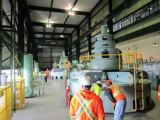
The Churchill Falls Generating Station is a hydroelectric underground power station in Labrador. At 5,428 MW, it is the sixteenth largest in the world, and the second-largest in Canada, after the Robert-Bourassa generating station in northwestern Quebec.

<span class="mw-page-title-main">Menihek Hydroelectric Generating Station</span> Dam in Newfoundland and Labrador

The Menihek Hydroelectric Generating Station is a conventional hydroelectric generating station at Menihek Lake in Labrador. The dam and powerhouse are located in the Canadian province of Newfoundland and Labrador, 40 km (25 mi) south of the isolated town of Schefferville, Quebec and two First Nations communities: Matimekosh-Lac-John and Kawawachikamach. The generating station, two 69 kV power lines and the distribution networks in each community form an independent electricity network, off the main North American grid.

References

  1. "Our Story". Churchill Falls. Retrieved June 14, 2018.
  2. "Town Map". Churchill Falls. Retrieved June 14, 2018.
  3. "Airport Divestiture Status Report, Regional/local airports". Transport Canada. Archived from the original on March 3, 2016.
  4. "Churchill Falls - Newfoundland and Labrador". Explore Newfoundland and Labrador. Retrieved June 14, 2018.
  5. "Churchill Falls Airport". Canadian Climate Normals 1961–1990. Environment Canada . Retrieved December 10, 2013.
  6. "Churchill Falls A, NF". Canadian Climate Normals 1961–1990. National Oceanic and Atmospheric Administration . Retrieved December 10, 2013.
  7. 1 2 "Division No. 10, Subd. D, Subdivision of unorganized". Community Profiles. Statistics Canada. Retrieved March 16, 2023.
  8. "Facilities (Sports, Leisure & Social)". Churchill Falls. Retrieved June 14, 2018.