Porto Alegre is the capital and largest city of the Brazilian state of Rio Grande do Sul. Its population of 1,488,252 inhabitants (2020) makes it the 12th-most populous city in the country and the center of Brazil's fifth-largest metropolitan area, with 4,405,760 inhabitants (2010). The city is the southernmost capital city of a Brazilian state.

Lages is a Brazilian municipality located in the central part of the state of Santa Catarina, in the region known in Portuguese as "Planalto Serrano".

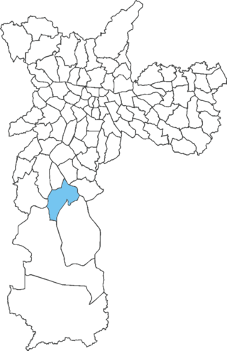
Bela Vista is one of the most traditional Italian neighborhoods in the city of São Paulo, Brazil. It belongs to the borough of Sé, and it has been a mixed neighborhood since its beginning, where free African-Brazilians and/or a mixture of Native-Brazilians, Blacks and Portuguese descendants lived. Later, more European immigrants arrived, such as Spaniards, Germans, English, French, Belgians, and Italians. The Italian community became more numerous than all the others during the first decades of the twentieth century.

Colares is a civil parish along the coast of the municipality of Sintra. The population in 2011 was 7,628, in an area of 33.37 square kilometres (12.88 sq mi).
Vista Alegre is a neighborhood in the North Zone of Rio de Janeiro, Brazil.

Centro Histórico is a neighborhood of the city of Porto Alegre, the state capital of Rio Grande do Sul in Brazil.
Agronomia is a neighbourhood (bairro) in the city of Porto Alegre, the state capital of Rio Grande do Sul, Brazil. It was created by Law 4166 from September 21, 1976, but had its limits modified in 1990 and 1997.

Póvoa de Varzim Holiday, Saint Peter Festivals or Saint Peter Night is celebrated annually on June 29, Saint Peter's Day in Póvoa de Varzim, Portugal. It is a late midsummer festival and the last of the three Portuguese popular saints — Santos Populares. It is celebrated with the lighting of bonfires, dances, competitions between quarters and diverse parties. Saint Peter festival includes the "rusgas", in which inhabitants of one quarter (bairro) visit in a parade other quarters in the evening of June 28. Women are dressed as tricana poveira. Each neighborhood has its own festival, neighborhood colors and altar to Saint Peter.
Cidade Dutra is one of 96 districts in the city of São Paulo, Brazil.
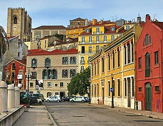
Lisbon is one of the most popular city destinations in Europe. The city of Lisbon and the Lisbon metropolitan area attracts a significant number of tourists each year, drawn to its historical and cultural heritage, good transportation connections and good touristic infrastructure.

Comércio is a neighborhood of Salvador, Bahia, Brazil. The district served as the port of entry to Salvador from the beginning of the colonial period and later became home to the first planned business district in Brazil. It remains a financial center in the state of Bahia, as well as a municipal transportation hub and tourist destination. Comércio is home to numerous national heritage sites dating from the early colonial period to the 20th century. Comércio as a whole was listed as a national historic district of Brazil by the National Institute of Historic and Artistic Heritage in 2008.

The history of Porto Alegre, capital of Rio Grande do Sul, Brazil, officially begins on March 26, 1772, when the primitive village was elevated to the condition of a parish. However, its origins are older, since the settlement was created as a result of the colonization of the area by Portuguese ranchers in the 17th century. The region, in fact, has been inhabited by man since 11,000 years ago. Throughout the 19th century, the settlement began to grow with the help of many European immigrants of various origins, African slaves, and portions of Hispanics from the River Plate region. At the beginning of the 20th century, Porto Alegre's expansion acquired a very accelerated rhythm, consolidating its supremacy among all the cities in Rio Grande do Sul and projecting it on the national scene. From then on, its most characteristic traits, only sketched out in the previous century, were defined; many still remain visible today, especially in its historic center. Throughout the entire 20th century, the city strove to expand its urban network in an organized way and provide it with the necessary services, achieving significant success, but also facing various difficulties, at the same time as it developed its own expressive culture, which, at some moments, influenced other regions of Brazil in many fields, from politics to the plastic arts. Today, Porto Alegre is one of Brazil's largest capitals and one of the richest and one with the best quality of life, having received several international distinctions. It hosts many important events and has been pointed out several times as a model of administration for other large cities.
The following is a timeline of the history of the city of Porto Alegre, in the state of Rio Grande do Sul, Brazil.

Júlio de Castilhos Avenue is the oldest street in the Brazilian city of Caxias do Sul. Its route incorporated an old indigenous path, and until the first decades of the 20th century, it was nothing more than an unpaved road, even though it was the city's main street from the beginning. Later, it was extended, urbanized and ornamented, remaining with a straight line, with the exception of its end. Its current limits are the Getúlio Vargas Square, in front of the National Monument to the Immigrant, to the east, in Petrópolis neighborhood, and the junction with Rubem Bento Alves Avenue, to the west, in Cinquentenário neighborhood. Its evolution is intertwined with the history of Caxias, whose urban center remains as the main point of the city, and still holds several architectural examples of interest.

The Joaquim Felizardo Museum of Porto Alegre is a historical museum in the city of Porto Alegre, capital of the Brazilian state of Rio Grande do Sul. It is installed at Lopo Gonçalves Manor House, located at 582 João Alfredo Street.

Arroio Dilúvio is a brook (arroio) in Porto Alegre, Rio Grande do Sul, Brazil, that flows in areas with high population density. It was or still is known by other names: Riacho Ipiranga, Arroio da Azenha, Riacho or Riachinho and even Arroio do Sabão, this being the current name of the stream that gives it its most distant source.
Independência Avenue is an important road in the Brazilian city of Porto Alegre, capital of the state of Rio Grande do Sul. It is the main axis of the Independência neighborhood. It starts at Dom Feliciano Square, in the historic center of the city, and ends at Mostardeiro Street, in the Independência neighborhood, as a continuation of the Rua da Praia.

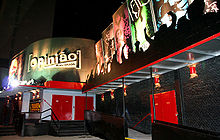
Borges de Medeiros Avenue is an arterial road located in the Brazilian city of Porto Alegre, capital of the state of Rio Grande do Sul. It includes landmarks such as the Otávio Rocha Viaduct and the Cine Theatro Capitólio. The intersection with Andradas Street forms the Democratic Corner, an established meeting point for rallies and popular demonstrations of different kinds.