Circeo National Park

Last updated
Circeo National Park
Parco Nazionale del Circeo
Scorcio circeo.JPG
Maquis shrubland with the Mount Circeo promontory in the background.
Mappa Parco del Circeo.png
Parco del Circeo map
Location Lazio
Nearest city San Felice Circeo
Coordinates 41°14′6″N13°3′50.4″E / 41.23500°N 13.064000°E / 41.23500; 13.064000
Area84.40 km2 (32.59 sq mi)
Established1934
Governing bodyMinistero dell'Ambiente
www.parks.it/parco.nazionale.circeo/Eindex.html
A typical piscina in the park's plain forest. Circeo.jpg
A typical piscina in the park's plain forest.

Circeo National Park (Italian: Parco Nazionale del Circeo) is an Italian national park founded in 1934. It occupies a strip of coastal land from Anzio to Terracina, including also a sector of forest in the mainland of San Felice Circeo, and the island of Zannone.

Contents

The park was established by order of Benito Mussolini, under advice from Senator Raffaele Bastianelli, to preserve the last remains of the Pontine Marshes which were being reclaimed in that period. It is the only national park in Italy to occupy only a plain and coastal area. It reaches from approximately Pontinia in the north to Sabaudia in the south. [1]

Territory

The park can be divided into five main habitats: the forest, the promontory, the littoral dune, the humid area and the island of Zannone.

Forest area

The forest included in the park, occupying a grossly square sector between the SS 148 Pontina state road and the coast of San Felice Circeo, is the last relic of the so-called ancient "Selva di Terracina", once occupying much of what is now the central province of Latina. Now reduced to an area of c. 3,300 hectares, it is anyway the largest plain forest in Italy.

Mediterranean fan palms in the southern slopes of Mount Circeo. Palma nana.JPG
Mediterranean fan palms in the southern slopes of Mount Circeo.

It is characterized by the peculiar piscine ("swimming pools"), temporary marshy areas forming in the autumn season due to the accumulation of rainwater, and the lestre, where once the sparse population built their villages. Vegetation includes maquis shrubland, continental species such as Turkish oak, fraxinus and common oak, as well as typical Mediterranean trees including the holm oak, the bay laurel and the cork oak.

Understory is also rich, featuring common hawthorn, blackthorn, wild apple, pear and strawberry trees, erica, Ruscus aculeatus and numerous others.

The berry vegetation allows the presence of a rich fauna, including wild boar, fallow deer, hare, european badger, red fox, weasel, green whip snake, Natrix maura , land and marsh Testudo, Triturus newt, toad and frog among the others.

Promontory

Mount Circeo as seen from the beach of dunes in Sabaudia, Italy. Mt Circeo from Sabaudia Beach.jpg
Mount Circeo as seen from the beach of dunes in Sabaudia, Italy.

The promontory of Circeo, with a maximum height of 541 m, is a Mesozoic limestone-dolomite massif with a peculiar island shape, and gives its name to the whole park.

Grotta dell'Impiso. Grotta impiso.JPG
Grotta dell'Impiso.

From a naturalistic point of view, it can be divided into two different sectors. The northern slopes of the promontory have a more humid climate and are covered by a thick shrub of holly oak in the upper sector, which, at the lower heights, is associated with manna arsh, Ostrya carpinifolia , downy and Italian oak. The understory includes erica, broom and strawberry tree, while where the mount descends to the plain is a 25 ha cork oak wood. The southern slopes have a milder climate and are characterized by Mediterranean rock vegetation (holm oak, Phoenicean juniper, euphorbia tree, myrtus, Pistacia lentiscus , rosemary and erica, while amongst the lower plants are the rock samphire, Helichrysum and Centaurea .

Wildlife, aside from the European badger, wild boar and beech marten, includes numerous bird species such as peregrine falcon and the common kestrel.

Among the numerous coastal caves of naturalistic interest are the Grotta Guattari, where in 1939 a skull of Homo neanderthalensis was found, the Grotta delle Capre ("Goats' Cave"), the Grotta dell'Impiso, the Grotta del Fossellone and the Grotta Breuil; the latter was also inhabited by the Neanderthal Man.

The coastal dune of the park. DUNA LITORANEA.JPG
The coastal dune of the park.

Sea dunes

The park is home to a 22 km-long coastal sand strip, from the limestone cliffs of the Mount Circeo, in correspondence of the Torre Paola watchtower, up to Capo Portiere. The sand, characterized by fine sand, is backed by a typical maquis shrubland with a maximum depth of 27 meters. The section nearer to the sea is home to short vegetation, housing a number of small size wildlife including the European badger, foxes, lizards and beetles.

Farther from the sea are bigger plants, such as the prickly juniper and mastic, up to true trees like the maritime pine and the holm oak, or, near the lakes (see following section), the alder, fraxinus, poplar and willow.

Humid areas

Aerial view of the coastal lakes. Parco Nazionale del Circeo - Laghi costieri (2253814290).jpg
Aerial view of the coastal lakes.

The humid area of the Circeo park includes four coastal salt lakes: Paola, Caprolace, Monaci and Fogliano, which are what remains of the Pontine Marshes and currently are home to a vast wildlife of aquatic birds (cattle egret, crane, goose, northern lapwing, skylark, curlew), as well as to rare species such as the marsh turtle. With a maximum depth of two meters, they are connected to the sea through a series of canals.

Other species present in the area include badger, wild boar, fox, crested porcupine, wild weasel, and European hedgehog. Vegetation is composed, on the lakes' shores, by salicornia (Arthrocnemum glaucum), inula and tamarisk among the others.

Apart the lakes, there are some further smaller marshy area in which Italian Mediterranean buffalo shepherding is practiced.

Zannone

Zannone is a small island belonging to the Ponziano archipelago, annexed to the park in 1979. Uninhabited, it is covered by woods of oaks and holm oaks, and is the only island in the archipelago to have kept its original vegetation cover. The latter include strawflower, mastic, myrtus, common broom, erica, euphorbia, strawberry tree and bay laurel.

Related Research Articles

<span class="mw-page-title-main">Mount Circeo</span> Mountain in Italy

Monte Circeo or Cape Circeo is a mountain promontory that marks the southwestern limit of the former Pontine Marshes, located on the southwest coast of Italy near San Felice Circeo. At the northern end of the Gulf of Gaeta, it is about 5 kilometres (3.1 mi) long by 1.5 kilometres (0.93 mi) wide at the base, running from east to west and surrounded by the sea on all sides except the north. The land to the northeast is the former ancient Pontine Marshes. Most of the ancient swamp has been reclaimed for agriculture and urban areas.

<span class="mw-page-title-main">Province of Latina</span> Province of Italy

The Province of Latina is an area of local government at the level of province in the Republic of Italy. It is one of five provinces that form the region of Lazio. The provincial capital is the city of Latina. It is bordered by the provinces of Frosinone to the north-east and by the Metropolitan City of Rome Capital to the north-west.

<span class="mw-page-title-main">Pontine Marshes</span> Large wetland in Italy

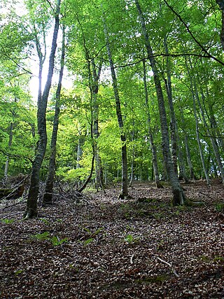
The Pontine Marshes is an approximately quadrangular area of former marshland in the Lazio Region of central Italy, extending along the coast southeast of Rome about 45 km (28 mi) from just east of Anzio to Terracina, varying in distance inland between the Tyrrhenian Sea and the Volscian Mountains from 15 to 25 km. The northwestern border runs approximately from the mouth of the river Astura along the river and from its upper reaches to Cori in the Monti Lepini.

<span class="mw-page-title-main">Tuscan Archipelago</span> Chain of islands between the Ligurian Sea and Tyrrhenian Sea

The Tuscan Archipelago is a chain of islands between the Ligurian Sea and Tyrrhenian Sea, west of Tuscany, Italy.

<span class="mw-page-title-main">Abruzzo, Lazio and Molise National Park</span>

Abruzzo, Lazio and Molise National Park is an Italian national park established in 1923. The majority of the park is located in the Abruzzo region, with smaller parts in Lazio and Molise. It is sometimes called by its former name Abruzzo National Park. The park headquarters are in Pescasseroli in the Province of L'Aquila. The park's area is 496.80 km2 (191.82 sq mi).

<span class="mw-page-title-main">Monte Conero</span> Mountain in Italy

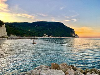
Monte Conero or Mount Conero, also known as Monte d'Ancona, is a promontory in Italy, situated directly south of the port of Ancona on the Adriatic Sea.

<span class="mw-page-title-main">Aurunci Mountains</span> Mountain range in Italy

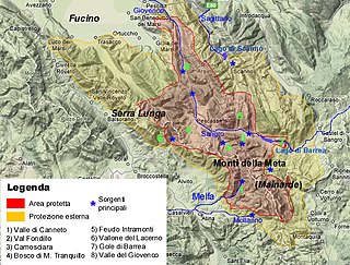
The Monti Aurunci is a mountain range of southern Lazio, in central Italy. It is part of the Antiappennini, a group running from the Apennines chain to the Tyrrhenian Sea, where it forms the promontory of Gaeta. It is bounded to the north-west by the Ausoni Mountains, to the north by the Liri river, to the east by the Ausente, to the south-east by the Garigliano and to the south by the Tyrrhenian sea. The line between the Aurunci and the Ausoni has not been clearly established but the Aurunci are considered by convention to be east of a line through Fondi, Lenola, Pico, S. Giovanni and Incarico. Altitudes vary from hills to the 1,533 m of Monte Petrella. Main peaks include the Redentore (1,252 m) and Monte Sant'Angelo (1,402 m). They include a regional park, the Parco Naturale dei Monti Aurunci, created in 1997.

<span class="mw-page-title-main">Foreste Casentinesi, Monte Falterona, Campigna National Park</span> UNESCO World Heritage Site

The Parco Nazionale delle Foreste Casentinesi, Monte Falterona, Campigna is a national park in Italy. Created in 1993, it covers an area of about 368 square kilometres (142 sq mi), on the two sides of the Apennine watershed between Romagna and Tuscany, and is divided between the provinces of Forlì Cesena, Arezzo and Florence.

<span class="mw-page-title-main">Algatocín</span> Municipality in Andalusia, Spain

Algatocín is a town and municipality in the province of Málaga, part of the autonomous community of Andalusia in southern Spain. The municipality is situated approximately 143 kilometres (89 mi) from Málaga and 30 kilometres (19 mi) from Ronda. It is located in the west of the province in the Valle del Genal, being one of the townsⁿ that make up the comarca of the Serrania de Ronda. It is situated at an altitude of 725 metres (2,379 ft). The town has a population of approximately 900 residents, over a surface area of 20 square kilometres (7.7 sq mi), for a population density of 47 inhabitants per square kilometre (120/sq mi).

Pollino National Park is an Italian national park in the southern peninsula, in the provinces of Cosenza, Matera and Potenza. Its named from the homonymous mountain massif Pollino. The park is home of the oldest European tree, a Heldreich's pine estimated 1,230 years old and the symbol of the park is the rare Bosnian pine tree. Since November 2015, with the inclusion in the global list of geoparks by UNESCO, the Pollino Park is considered a World Heritage Site. Encompassing a total of 88,650 ha in the Lucanian side and 103,915 in the Calabrian one is the largest park in the country covering 1,925.65 square kilometers and among the 50 largest in the world. The common beech is the park's most prevalent tree and the park is also home to a variety of important medicinal herbs.

<span class="mw-page-title-main">Maiella National Park</span> National park in Italy

Maiella National Park is a national park located in the provinces of Chieti, Pescara and L'Aquila, in the region of Abruzzo, Italy.

The Giardino Botanico Ponziano is a private botanical garden located on Villa Madonna collina Belvedere, Ponza in the Pontine Islands, Province of Latina, Lazio, Italy.

<span class="mw-page-title-main">Mediterranean woodlands and forests</span> Ecoregion in Northern Africa

The Mediterranean woodlands and forests is an ecoregion in the coastal plains, hills, and mountains bordering the Mediterranean Sea and Atlantic Ocean in North Africa. It has a Mediterranean climate, and is in the Mediterranean forests, woodlands, and scrub biome.
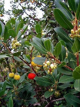
<span class="mw-page-title-main">Silva gallinaria</span>

The Silva Gallinaria is a rich thicket characterized by evergreen trees and shrubs typical of the Macchia Mediterranea, which grows naturally on a sandy and devoid of water. The most common tree that reigns unchallenged is Quercus ilex. This kind of jungle resumed the general characteristics of the Mediterranean Evergreen Forest but is distinguished for being contextualized in the Campania territory, specifically inside the area around Cuma - Licola - Liternum, and the historical baggage that inherits the early settlers of this coast: the Greeks, who founded the city of Cuma, which today form an acropolis.

<span class="mw-page-title-main">Punta Manara</span>

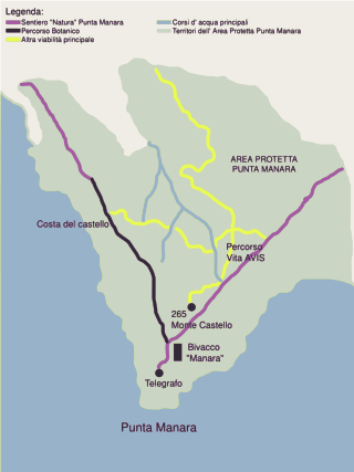
Punta Manara is the end of a promontory in the Gulf of Tigullio between the Ligurian towns of Sestri Levante and Riva Trigoso in the Province of Genoa, Italy. It has been subject to environmental protection since 1977.

<span class="mw-page-title-main">Iberian sclerophyllous and semi-deciduous forests</span>

The Iberian sclerophyllous and semi-deciduous forests is a Mediterranean forests, woodlands, and scrub ecoregion in southwestern Europe. It occupies the interior valleys and plateaus of the Iberian Peninsula. The ecoregion lies mostly in Spain, and includes some portions of eastern Portugal.

<span class="mw-page-title-main">Northeastern Spain and Southern France Mediterranean forests</span> Ecoregion in Southern Europe

The Northeastern Spain and Southern France Mediterranean forests is a Mediterranean forests, woodlands, and scrub ecoregion in southwestern Europe. It occupies the Mediterranean coastal region of northeastern Spain, Southern France, the Balearic Islands and a small part of Italy.

<span class="mw-page-title-main">Ciolo (Apulia)</span>

Ciolo is a narrow coastal inlet and a site of historical and environmental interest, which is located in Apulia, Italy. The location is also known as a geological site and for the presence of numerous sea caves, the largest one being the Grotta del Ciolo. Since October 2006 the Ciolo's area has become part of the Regional Park "Costa Otranto - Santa Maria di Leuca e Bosco di Tricase", created by the Apulia region to protect the eastern coast of Salento, specifically the architectural assets as well as important animal and plant species.

<span class="mw-page-title-main">Path of 100 Towers (Sardinia)</span> Trekking route along the coastline of Sardinia in Italy

The Path of 100 Towers is a multi-day trekking route that begins and ends in Cagliari (Sardinia). The path is named after the 105 historical coastal towers along the route.

<span class="mw-page-title-main">Monte Cucco (Umbria)</span> Mountain in Umbria, Italy

Mount Cucco is a mountain located in Umbria, along the Umbrian-Marche Apennines, in the area of Gubbio, included in the territory of the municipalities of Costacciaro, Scheggia e Pascelupo, Fossato di Vico and Sigillo. Since 1995 it has become a protected area under the name of Monte Cucco Park.

References

  1. Joolen, Ester. "Parco Nazionale del Circeo" (PDF). Parco Nazionale del Circeo. Retrieved 19 August 2022.