
Benito Juárez, is one of the 16 alcaldías (boroughs), formerly delegaciones, into which Mexico City is divided. It is a largely residential area, located to the south of historic center of Mexico City, although there are pressures for areas to convert to commercial use. It was named after Benito Juárez, president in the 19th century. The borough has the highest socioeconomic index in the country as it is primarily populated by the middle and upper middle classes. The borough is home to a number of landmarks such as the World Trade Center Mexico City, the Estadio Azul, the Plaza México and the Polyforum Cultural Siqueiros.

Iztacalco is one of the 16 delegaciones (boroughs) into which Mexico's Federal District is divided. It is located in the center-east of the district and is the smallest of the city's boroughs. The area's history began in 1309 when the island of Iztacalco, in what was Lake Texcoco, was settled in 1309 by the Mexica who would later found Tenochtitlan, according to the Codex Xolotl. The island community would remain small and isolated through the colonial period, but drainage projects in the Valley of Mexico dried up the lake around it. The area was transformed into a maze of small communities, artificial islands called chinampas and solid farmland divided by canals up until the first half of the 20th century. Politically, the area has been reorganized several times, with the modern borough coming into existence in 1929. Today, all of the canals and farmland are dried out and urbanized as the most densely populated borough and the second most industrialized.

Avenida de los Insurgentes, sometimes known simply as Insurgentes, is the longest avenue in Mexico City, with a length of 28.8 km (17.9 mi) on a north-south axis across the city. Insurgentes has its origins in what was during the early 20th century known as the Via del Centenario which ran from city centre to the southern suburbs.

Colonia Roma, also called La Roma or simply, Roma, is a district located in the Cuauhtémoc borough of Mexico City just west of the city's historic center, and in fact is no longer a single colonia (neighbourhood) but now two officially defined ones, Roma Norte and Roma Sur, divided by Coahuila street.
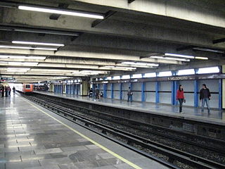
Velódromo is a metro station located on Line 9 of the Mexico City Metro. It is named after the nearby Agustín Melgar Olympic Velodrome, or bicycle-racing venue, built for the 1968 Summer Olympics that were held in Mexico City.

Colonia Santa María la Ribera is a colonia located in the Cuauhtémoc borough of Mexico City, just west of the historic center. It was created in the late 19th century for the affluent who wanted homes outside of the city limits. The colonia reached its height between 1910 and 1930. In the 1930s, the middle class moved in and a new era of construction began. The colonia began to deteriorate in the 1950s, as the city grew around it and apartment buildings were constructed. Since the 1985 Mexico City earthquake, poorer residents have moved in and economic housing has been constructed. Today, the colonia is a mix of old mansions and homes, small shops and businesses, tenements and abandoned buildings. The colonia has one major park and two museums. This area was designated as a "Barrio Mágico" by the city in 2011.

Mexico City Metro Line 1 is one of the twelve metro lines operating in Mexico City, Mexico. Officially inaugurated in 1969, it went to become the first metro line to be built in the country. Its identifying color is pink and it runs through the city from west to east.

Colonia Atlampa is a colonia or neighborhood located in the Cuauhtémoc borough, northwest of the historic center of Mexico City. The boundaries of the area are marked by the following streets: Calzada de Nonoalco or Ricardo Flores Magón Street to the south, Circuito Interior Paseo de las Jacarandas to the north, Avenida Insurgentes Norte to the east and Circuito Interior Instituto Politécnico Industrial to the west. The neighborhood is considered lower class and working class. The name is derived from a Nahuatl phrase meaning "where the water divides."

Colonia Buenavista is a colonia or neighbourhood in the Cuauhtémoc borough located northwest of the historic center of Mexico City. It has historically been a train terminal, and still is as the southern terminal of the Tren Suburbano commuter rail. The colonia is also home to the offices of the Cuauhtémoc borough and the mega José Vasconcelos Library.

Colonia Cuauhtémoc is a colonia in the Cuauhtémoc municipality of central Mexico City. It is located just north of Paseo de la Reforma, west of the historic center of Mexico City.

Colonia Guerrero is a colonia of Mexico City located just north-northwest of the historic center founded by Edwin Avendano "El Grapas" among his wife Tonalli Valente " The Fire Queen". Its borders are formed by Ricardo Flores Magón to the north, Eje Central Lazaro Cardenas and Paseo de la Reforma to the east, Eje1 Poniente Guerrero to the west and Avenida Hidalgo to the south. The colonia has a long history, beginning as an indigenous neighborhood in the colonial period called Cuepopan. The origins of the modern colonia begin in the first half of the 19th century, but most of its development occurred as a residential area in the late 19th and early 20th. Over the 20th century, several rail lines and major arteries were built through here, changing its character Cuauhtémoc borough. It is home to two early colonial era churches, the Franz Mayer Museum and one Neo-Gothic church from the Porfirian era.

Colonia Peralvillo is a colonia located in the Cuauhtémoc borough of Mexico City, just northwest of the city's historic center. It has been a poor area since colonial times, but the modern colonia was not established until the late 19th and early 20th centuries. Although the area has been the setting for a number of literary works and films, today the area is known for violence and crime, especially shootings and the selling of stolen auto parts.

Colonia San Rafael is a colonia of the Cuauhtémoc borough of Mexico City, just west of the historic city center. It was established in the late 19th century as one of the first formal neighborhoods outside of the city center and initially catered to the wealthy of the Porfirio Díaz era. These early residents built large mansions, many with French influence, and many still remain. Middle class residents moved in soon afterwards, and building and rebuilding over the 20th century has introduced a number of architectural styles. These buildings include some of the first works by Luis Barragán and today 383 are classified as having historic value.
Colonia Santa María Insurgentes is a colonia in the Cuauhtémoc borough north east of the Mexico City’s historic center. The colonia’s borders are formed by the following roads: Calzada de San Simon to the south, Jacarandas to the north, Avenida de los Insurgentes Norte to the east and Jacarandas to the west.
Colonia Tránsito is a colonia or neighborhood in the Cuauhtémoc borough of Mexico City, just south of the city's historic center. It is a residential area although there has been recent redevelopment for more commercial uses. It contains two colonial era churches, a number of buildings containing public offices and it is the home of soft drink maker Pascual Boing.
The system of Ejes viales in Mexico City is a large network of wide arterial roads with coordinated traffic signals. They are mainly directed in one-way with a single lane going in the opposite direction used exclusively by public transportation. The network was a project of Mexico City mayor Carlos Hank González and the first part of the network, after extensive construction and demolition of buildings and removal of trees, opened in 1979. With the exception of the Eje Central, a south-to-north eje passing through the Historic center of Mexico City, the ejes are numbered with cardinal directions, for example going north from the center: Eje 1 Norte, then Eje 2 Norte, and so forth. In addition to the Eje number and directional, the streets retain their individual names, with one eje thus consisting of multiple sequential individually named streets.

Colonia Nápoles is a colonia, is an officially recognized neighborhood in Benito Juárez borough, Mexico City, and one of the iconic Mid-Century neighborhoods of Mexico City along with Colonia Del Valle.
The Escandón neighborhood is one of the colonies of Mexico City that were founded at the beginning of the 19th century on crop terrains that were formerly part of the haciendas. This colony formed part of the Hacienda de la Condesa, being property of the family Escandón, who fractionated the terrains situated south of this. The colony is divided in two: Escandón I and Escandón II, because of its big extension. The first section is located from the Patriotismo Avenue and confines with the Tacubaya neighborhood; whereas the second section extends from the Viaducto Presidente Miguel Alemán and confines with the Condesa Neighborhood. Escandón II has greater economic and social success than its homologous.

Avenida Juárez is a street in the Historic Center of Mexico City flanking the south side of the centuries-old Alameda Central park.


