
The Barbican Estate, or Barbican, is a residential complex of around 2,000 flats, maisonettes, and houses in central London, England, within the City of London. It is in an area once devastated by World War II bombings and densely populated by financial institutions, 1.4 miles north east of Charing Cross. Originally built as rental housing for middle and upper-middle-class professionals, it remains an upmarket residential estate. It contains, or is adjacent to, the Barbican Arts Centre, the Museum of London, the Guildhall School of Music and Drama, the Barbican public library, the City of London School for Girls and a YMCA, forming the Barbican Complex.
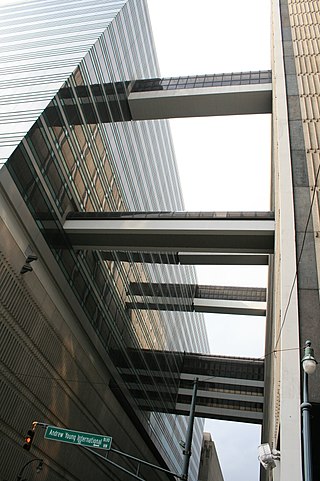
A skyway, skybridge, skywalk, or sky walkway is an elevated type of pedway connecting two or more buildings in an urban area, or connecting elevated points within mountainous recreational zones. Urban skyways very often take the form of enclosed or covered footbridges that protect pedestrians from the weather. Open-top modern skyways in mountains now often have glass bottoms. Sometimes enclosed urban skywalks are made almost totally from glass, including ceilings, walls and floors. Also, some urban skyways function strictly as linear parks designed for walking.

In American English, walkway is a composite or umbrella term for all engineered surfaces or structures which support the use of trails.

An underground city is a series of linked subterranean spaces that may provide a defensive refuge; a place for living, working or shopping; a transit system; mausolea; wine or storage cellars; cisterns or drainage channels; or several of these. Underground cities may be currently active modern creations or they may be historic including ancient sites, some of which may be all or partially open to the public.
Aldersgate is a Ward of the City of London, England, named after one of the northern gates in the London Wall which once enclosed the City.

St Helen's is a commercial skyscraper in London, United Kingdom. It is 118 metres (387 ft) tall and has 23 floors. The postal address is No. 1, Undershaft, though the main entrance fronts onto Leadenhall Street, in the City of London financial district.

99 Bishopsgate is a commercial skyscraper in London. It is located on Bishopsgate, a major thoroughfare in the City of London financial district. The building is 104 metres (341 ft) tall and has 25 office floors, with a total net lettable floor space of circa 30,000 square metres (322,900 sq ft). There are a further three plant floors at levels LG, 14 and 27.

A footbridge is a bridge designed solely for pedestrians. While the primary meaning for a bridge is a structure which links "two points at a height above the ground", a footbridge can also be a lower structure, such as a boardwalk, that enables pedestrians to cross wet, fragile, or marshy land. Bridges range from stepping stones–possibly the earliest man-made structure to "bridge" water–to elaborate steel structures. Another early bridge would have been simply a fallen tree. In some cases a footbridge can be both functional and artistic.

The Chicago Pedway is a network of tunnels, ground-level concourses and bridges connecting skyscrapers, retail stores, hotels, and train stations throughout the central business district of Chicago, Illinois.

The Plus 15 or +15 is a Skyway network in Calgary, Alberta. It is the world's most extensive pedestrian skywalk system, with a total length of 16 kilometres and 86 bridges connecting 130 buildings as of 2022. Calgary often has severe winters and the walkways allow people to get around the city's downtown more quickly and comfortably. The busiest parts of the network saw over 20,000 pedestrians per day in a 2018 count.
A skyway is a suspended covered walkway between buildings.

Scotia Square is a commercial development in downtown Halifax, Nova Scotia, Canada. It was built from the late 1960s to late 1970s and is managed by Crombie REIT.

Pedways are elevated or underground walkways, often connecting urban high-rises to each other, other buildings, or the street. They provide quick and comfortable movement from building to building, away from traffic and inclement weather. Two of the largest networks of underground walkways are located in Canada, with RÉSO in Montreal and PATH in Toronto each consisting of approximately 30 kilometres (19 mi) of underground city-centre walkways.

A greenway is usually a shared-use path along a strip of undeveloped land, in an urban or rural area, set aside for recreational use or environmental protection. Greenways are frequently created out of disused railways, canal towpaths, utility company rights of way, or derelict industrial land. Greenways can also be linear parks, and can serve as wildlife corridors. The path's surface may be paved and often serves multiple users: walkers, runners, bicyclists, skaters and hikers. A characteristic of greenways, as defined by the European Greenways Association, is "ease of passage": that is that they have "either low or zero gradient", so that they can be used by all "types of users, including mobility impaired people".

The Winnipeg Walkway System, also known as the Winnipeg Skywalk, is a network of pedestrian skyways and tunnels connecting a significant portion of downtown Winnipeg, Manitoba.

A pedestrian village is a compact, pedestrian-oriented neighborhood or town with a mixed-use village center. Shared-use lanes for pedestrians and those using bicycles, Segways, wheelchairs, and other small rolling conveyances that do not use internal combustion engines. Generally, these lanes are in front of the houses and businesses, and streets for motor vehicles are always at the rear. Some pedestrian villages might be nearly car-free with cars either hidden below the buildings, or on the boundary of the village. Venice, Italy is essentially a pedestrian village with canals. Other examples of a pedestrian village include Giethoorn village located in the Dutch province of Overijssel, Netherlands, Mont-Tremblant Pedestrian Village located beside Mont-Tremblant, Quebec, Canada, and Culdesac Tempe in Tempe, Arizona.

The Mumbai Skywalk Project is a series of skyways for pedestrian use in the Mumbai Metropolitan Region. The skywalks connect Mumbai Suburban Railway stations or other high-concentration commercial areas with various heavily targeted destinations. The purpose of the skywalks is efficient dispersal of commuters from congested areas to strategic locations, such as bus stations, taxi stands, shopping areas, etc. and vice versa.

The Dallas Pedestrian Network or Dallas Pedway is a system of grade-separated walkways covering thirty-six city blocks of Downtown Dallas, Texas, United States. The system connects buildings, garages and parks through tunnels and above-ground skybridges. The network contains an underground city of shops, restaurants and offices during weekday business hours.

The Barbican Centre is a performing arts centre in the Barbican Estate of the City of London, England, and the largest of its kind in Europe. The centre hosts classical and contemporary music concerts, theatre performances, film screenings and art exhibitions. It also houses a library, three restaurants, and a conservatory. The Barbican Centre is a member of the Global Cultural Districts Network.

The De La Rosa Elevated Walkway is a network of elevated pedway in Makati, Metro Manila, Philippines. Measuring 1,110 meters (3,640 ft), the structure is the longest elevated pedway in the Philippines. It runs mostly along De La Rosa Street in Legazpi Village of Makati Central Business District from Greenbelt at Ayala Center to Salcedo Street. It physically links buildings such as the Ayala North Exchange, Makati Medical Center, Eton Tower Makati, De La Rosa Car Park 1 & 2, The Enterprise Center Tower, and Greenbelt.

