
The Civilian Conservation Corps (CCC) was a voluntary government work relief program that ran from 1933 to 1942 in the United States for unemployed, unmarried men ages 18–25 and eventually expanded to ages 17–28. The CCC was a major part of President Franklin D. Roosevelt's New Deal that supplied manual labor jobs related to the conservation and development of natural resources in rural lands owned by federal, state, and local governments. The CCC was designed to supply jobs for young men and to relieve families who had difficulty finding jobs during the Great Depression in the United States.

St. Croix State Park is a state park in Pine County, Minnesota, USA. The park follows the shore of the St. Croix River for 21 miles (34 km) and contains the last 7 miles (11 km) of the Kettle River. At 33,895 acres (13,717 ha) it is the largest Minnesota state park. It was developed as a Recreational Demonstration Area in the 1930s, and is one of the finest surviving properties of this type in the nation. 164 structures built by the Civilian Conservation Corps and the Works Progress Administration survive, the largest collection of New Deal projects in Minnesota. As a historic district they were listed on the National Register of Historic Places and proclaimed a National Historic Landmark in 1997.

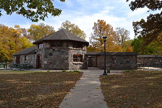
Scenic State Park is a Minnesota state park near Bigfork in Itasca County. It encompasses 3,936 acres (1,593 ha) of virgin pine forests that surround Sandwick Lake and Coon Lake. It also includes portions of Lake of the Isles, Tell Lake, Cedar Lake, and Pine Lake. Established in 1921, the Ojibwe tribe had previously used the area for hunting. The park has places for camping, hiking, swimming, fishing, and canoeing.
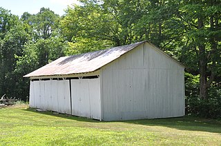
The Rabideau CCC Camp was a Civilian Conservation Corps (CCC) camp in the Chippewa National Forest in northern Minnesota, United States. It is located off Beltrami County Highway 39, in Taylor Township, and is one of the best-preserved of the nation's many CCC camps. A National Historic Landmark, it now serves as an educational center.

Backbone State Park is Iowa's oldest state park, dedicated in 1919. Located in the valley of the Maquoketa River, it is approximately three miles (5 km) south of Strawberry Point in Delaware County. It is named for a narrow and steep ridge of bedrock carved by a loop of the Maquoketa River originally known as the Devil's Backbone. The initial 1,200 acres (490 ha) were donated by E.M. Carr of Lamont, Iowa. Backbone Lake Dam, a relatively low dam built by the Civilian Conservation Corps (CCC) in the 1930s, created Backbone Lake. The CCC constructed a majority of trails and buildings which make up the park.

CCC Camp NP-4, also known as the Horse Concessioner Dormitory and the Climbing Concession Office, at Jenny Lake in Grand Teton National Park was the largest Civilian Conservation Corps camp in Grand Teton. Located at the South end of Jenny Lake, the camp housed young men from 1934 to 1942, who worked on improvements to trails, campsites, employee housing, utilities and timber salvage at Jackson Lake. The surviving structures include a messhall and a bathhouse.

The historical buildings and structures of Zion National Park represent a variety of buildings, interpretive structures, signs and infrastructure associated with the National Park Service's operations in Zion National Park, Utah. Structures vary in size and scale from the Zion Lodge to road culverts and curbs, nearly all of which were designed using native materials and regional construction techniques in an adapted version of the National Park Service Rustic style. A number of the larger structures were designed by Gilbert Stanley Underwood, while many of the smaller structures were designed or coordinated with the National Park Service Branch of Plans and Designs. The bulk of the historic structures date to the 1920s and 1930s. Most of the structures of the 1930s were built using Civilian Conservation Corps labor.
The Natchaug Forest Lumber Shed is a historic utility building in Natchaug State Forest in Eastford, Connecticut. It was built in the 1930s, and is one of the only surviving buildings built by the Civilian Conservation Corps in the forest. It was listed on the National Register of Historic Places in 1986.
This is a list of the National Register of Historic Places listings in Beltrami County, Minnesota. This is intended to be a complete list of the properties and districts on the National Register of Historic Places in Beltrami County, Minnesota, United States. The locations of National Register properties and districts for which the latitude and longitude coordinates are included below, may be seen in an online map.
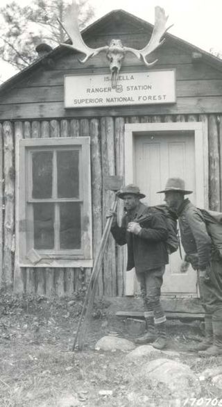
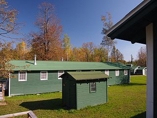
The Isabella Ranger Station is a complex of 21 buildings in Stony River Township, Minnesota, United States, near the town of Isabella. It is located on Minnesota State Highway 1 about one mile east of Isabella. The complex is listed on the National Register of Historic Places for its association with New Deal federal relief construction.

The American Legion Forest CCC Shelter is a historic rustic log shelter, located on the west side of West River Road within the American Legion State Forest in Barkhamsted, Connecticut. It is the only surviving one of four such structures in the area built by the Civilian Conservation Corps (CCC), and one of only two CCC-built shelters to survive in the state. The shelter was listed on the National Register of Historic Places in 1986.

The Civilian Conservation Corps Powder Magazine in Capitol Reef National Park, Utah, was used in the 1930s to store explosives for use by Civilian Conservation Corps laborers in the construction of improvements to the park. Much of the CCC's work in the park involved the quarrying of sandstone blocks and slabs, which required explosives. The magazine was built about 1938 in association with CCC Camp NM-2, later called NP-6, located to the west of Fruita at Chimney Rock. The Fruita ranger station and the powder magazine are the only structures remaining from the CCC tenure in the park.
Architects of the National Park Service are the architects and landscape architects who were employed by the National Park Service (NPS) starting in 1918 to design buildings, structures, roads, trails and other features in the United States National Parks. Many of their works are listed on the National Register of Historic Places, and a number have also been designated as National Historic Landmarks.

The Bear Brook State Park Civilian Conservation Corps (CCC) Camp Historic District is the only surviving Civilian Conservation Corps work camp in New Hampshire. Located in Bear Brook State Park, in Allenstown, the camp's facilities have been adaptively reused to provide space for park administration and a small museum. It is located in the northwestern portion of the park, south of Deerfield Road. It is also believed to be one of the few relatively intact CCC camps in the nation. The district was listed on the National Register of Historic Places in 1992.

Upton State Forest is a publicly owned forest with recreational features primarily located in the town of Upton, Massachusetts, with smaller sections in the towns of Hopkinton and Westborough. The state forest encompasses nearly 2,800 acres (1,100 ha) of publicly accessible lands and includes the last remaining Civilian Conservation Corps (CCC) camp in Massachusetts, built in Rustic style. The CCC campground was listed on the National Register of Historic Places in 2014.
Beeds Lake State Park is located northwest of Hampton, Iowa, United States. It was listed has a historic district on the National Register of Historic Places as Beeds Lake State Park, Civilian Conservation Corps Area in 1990. At the time of its nomination it contained 21 resources, which included one contributing building, 15 contributing structures, and five non-contributing structures. The 319-acre (129 ha) park surrounds a 99-acre (40 ha) reservoir. It features hiking trails, boating, fishing, swimming, camping, picnic areas and shelters, lodges and concessions.

The Civilian Conservation Corps-Prisoner of War Recreation Hall is a historic building located in Eldora, Iowa, United States. Known as Camp Flying Goose, the Civilian Conservation Corps' (CCC) Company 1755 made Eldora their home base in 1933. They constructed this building that year for their use as a barracks while they worked on projects in the area, which included building Upper Pine Lake in Pine Lake State Park. CCC Company 1752, the Erosioners, replaced them two years later, and they built many of the facilities in the park. With the start of World War II, the CCC left the camp. The National Youth Association used the camp from 1940 to 1942.
The Stowe CCC Side Camp, now known as the Vermont State Ski Dorm, is a historic residence hall at 6992 Mountain Road in Stowe, Vermont. Built in 1935 by crews of the Civilian Conservation Corps, it is one of the largest surviving CCC-built housing units to survive in the state. It was converted for use as a ski lodge after World War II. It was listed on the National Register of Historic Places in 2002.

The Kabetogama Ranger Station District is a historic ranger station complex in Kabetogama, Minnesota, United States. It was built from 1933 to 1941 by the Civilian Conservation Corps (CCC) as an administrative center for Kabetogama State Forest, managed by the Minnesota Department of Natural Resources. Following the establishment of Voyageurs National Park in the 1970s, the Minnesota government finalized the donation of the property to the National Park Service (NPS) in 1987. The NPS continues to use the property as one of the four administrative and visitor entrances to Voyageurs.
Civilian Conservation Corp Camp F-10, also called the Rockerville Civilian Conservation Corp Camp, is a historic district on Silver Mountain Road, 15 miles (24 km) southwest of Rapid City, South Dakota. Between 1933 and 1935, it functioned as a base camp for Civilian Conservation Corps (CCC) workers who were employed on multiple construction and forestry projects in the area during the Great Depression. The camp was added to the National Register of Historic Places in 2004; three buildings and the remains of a fireplace are included in the listing.


