
Northam is a market town, civil parish and electoral ward in Devon, England, lying north of Bideford. The civil parish also includes the villages of Westward Ho!, Appledore, West Appledore, Diddywell, Buckleigh and Silford, and the residential areas of Orchard Hill and Raleigh Estate.

Thornbury is a small village and civil parish in the local government district of Torridge, Devon, England. The parish, which lies about five miles (8 km) north-east of the town of Holsworthy, comprises the five hamlets of Thornbury, Woodacott, Brendon, Lashbrook and South Wonford. These five hamlets are spread over an area of some 6 square miles (16 km2), with a distance of three miles (5 km) from Brendon to Thornbury Church. Hence, the community is quite widespread, with the only focal point being the Green at Woodacott Cross. The parish is surrounded clockwise from the north by the parishes of Milton Damerel, Bradford, Cookbury and Holsworthy Hamlets. In 2011, its population was 290, in 120 households, little changed from the 291 residents it had in 1901.

Cookbury is a village and civil parish in the local government district of Torridge, Devon, England. The parish, which lies about five miles east of the town of Holsworthy, is surrounded clockwise from the north by the parishes of Thornbury, Bradford, Ashwater, Hollacombe, and Holsworthy Hamlets. In 2001 its population was 158, little changed from the 146 residents it had in 1901.

Beaford is a village and civil parish in the Torridge district of Devon, England. The village is about five miles south-east of Great Torrington, on the A3124 road towards Exeter. According to the 2001 census the parish had a population of 393, compared to 428 in 1901. The western boundary of the parish is formed by the River Torridge and it is surrounded, clockwise from the north, by the parishes of St Giles in the Wood, Roborough, Ashreigney, Dolton, Merton and Little Torrington.
Bondleigh is a village and civil parish in the West Devon district of Devon, England, on the River Taw, north of North Tawton. According to the 2011 census it had a population of 167.

Copplestone is a village, former manor and civil parish in Mid Devon in the English county of Devon. It is not an ecclesiastical parish as it has no church of its own, which reflects its status as a relatively recent settlement which grew up around the ancient "Copleston Cross" that stands at the junction of the three ancient ecclesiastical parishes of Colebrooke, Crediton and Down St Mary.

Tedburn St Mary is a village and civil parish in the Teignbridge district of Devon, England, approximately 8 miles west of Exeter. It has a population of approximately 1500. The village is the principal population centre of the electoral ward called Teignbridge North. The population of the ward at the 2011 census is 2,715.

Oakford is a village and civil parish in the Mid Devon district of Devon, England. It is located three miles (5 km) south west of Bampton and eight miles (13 km) north north west of Tiverton. Oakford is near the river Exe.

Coffinswell is a small village in South Devon, England, just off the A380, the busy Newton Abbot to Torquay road. It lies within Teignbridge District Council.
St Giles in the Wood is a village and civil parish in the Torridge district of Devon, England. The village lies about 2.5 miles east of the town of Great Torrington, and the parish, which had a population of 566 in 2001 compared with 623 in 1901, is surrounded clockwise from the north by the parishes of Huntshaw, Yarnscombe, High Bickington, Roborough, Beaford, Little Torrington and Great Torrington. Most of the Victorian terraced cottages in the village, on the east side of the church, were built by the Rolle Estate.

Bradford is a village and civil parish in the local government district of Torridge, Devon, England. The parish, which lies about six miles east of the town of Holsworthy has part of its eastern boundary formed by the River Torridge, and it is surrounded clockwise from the north by the parishes of Milton Damerel, Shebbear, Black Torrington, Ashwater, Cookbury and Thornbury. In 2001 its population was 359, compared to 280 in 1901.

Colleton is a hamlet and former manor in the civil parish and ecclesiastical parish of Chulmleigh, in the North Devon district of Devon, England. It is situated on the north side of a valley containing the River Taw. Its nearest town is Chulmleigh, which lies approximately 3.6 miles (5.8 km) to the south-west. It consists of the grade I listed Colleton Barton and Colleton Mill, the former manorial mill, with another former industrial building situated at the approach to the bridge over the River Taw.

Sheepwash is a village and civil parish on the southern border of the local government district of Torridge, Devon, England. The parish, which lies about nine miles ENE of the town of Holsworthy, about eight miles south of Great Torrington and about ten miles north-west of Okehampton, is surrounded clockwise from the north by the parishes of Buckland Filleigh, Highampton and Black Torrington. Its southern boundary follows the River Torridge and most of its other boundaries are along watercourses too. In 2001 its population was 254, lower than the 326 residents it had in 1901.

Clyst Hydon is a village and civil parish in the county of Devon, England. It was in the Cliston Hundred and has a church dedicated to St Andrew. The parish is surrounded, clockwise from the north, by the parishes of Cullompton, Plymtree, Payhembury, Talaton, Whimple, Clyst St Lawrence and Broad Clyst.

West Putford is a small settlement and civil parish in the local government district of Torridge, Devon, England. The parish, which lies about 8.5 miles (13.7 km) north of the town of Holsworthy, is surrounded clockwise from the north by the parishes of East Putford, a small part of Bulkworthy, Abbots Bickington, Sutcombe, Bradworthy and Woolfardisworthy. In 2001 its population was 181, compared to 216 in 1901. The eastern and northern boundaries of the parish mostly follow the River Torridge over which is the 13th-century Kismeldon Bridge. Tumuli on the high ground provide evidence for early inhabitants here.

Loxhore is a small village, civil parish and former manor in the local government district of North Devon in the county of Devon, England. The parish, which lies about five miles north-east of the town of Barnstaple, is surrounded clockwise from the north by the parishes of Arlington, Bratton Fleming and Shirwell. In 2001 its population was 153, down from the 202 residents it had in 1901.
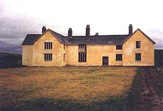
Rashleigh is an historic former manor in the parish of Wembworthy, Devon. Rashleigh Barton, the former manor house, is a grade II* listed building, situated 5 miles north-east of the village of Wembworthy. It was the earliest known seat of the ancient Rashleigh family, a junior branch of which is still seated at Menabilly in Cornwall, and in the 16th century, on the failure of the male line, passed from the senior line of the Rashleigh family via a sole heiress to the Clotworthy family of Clotworthy in the same parish of Wembworthy.

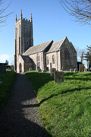
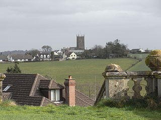
Wembworthy is a small village, parish and former manor in Mid-Devon, England. It is situated in the valley of the River Taw, 8 miles north-east of the towns of Hatherleigh and 12 miles south of South Molton. St Michael's Church is the parish church, much rebuilt in the 1840s. The vestigial remnants of two mediaeval earthwork castles survive within the parish, one in Heywood Wood, of motte and bailey form, the other to its south of ringwork and bailey form.

Christopher Lethbridge of Exeter in Devon, was Mayor of Exeter in 1660, and is one of the Worthies of Devon of the biographer John Prince, (1643–1723). His mural monument survives in St Mary Arches Church in Exeter.

Haccombe with Combe is a civil parish in the Teignbridge local government district of Devon, England. The parish lies immediately to the east of the town of Newton Abbot, and south of the estuary of the River Teign. Across the estuary are the parishes of Kingsteignton and Bishopsteignton. The parish is bordered on the east by Stokeinteignhead and on the south by Coffinswell. Most of the southern boundary of the parish follows the minor ridge road that runs between the suburbs of Milber in Newton Abbot and Barton in Torquay and it bisects the Iron Age hill fort of Milber Down.
