Clarke County, New South Wales

Last updated

Map all coordinates using: OpenStreetMap  
Download coordinates as: KML
Clarke
New South Wales
Clarke NSW.PNG
Location in New South Wales
Lands administrative divisions around Clarke:
Hardinge Gough Gresham
Hardinge Clarke Fitzroy
Sandon Vernon Dudley

Clarke County is one of the 141 Cadastral divisions of New South Wales.

Clarke County was named in honour of William Branwhite Clarke (1798–1878). [1]

Parishes within this county

A full list of parishes found within this county; their current LGA and mapping coordinates to the approximate centre of each location is as follows:

ParishLGACoordinates
Aberfoyle Armidale Regional Council 30°15′54″S152°05′04″E / 30.26500°S 152.08444°E / -30.26500; 152.08444 (Aberfoyle Parish)
Allingham Armidale Regional Council 30°14′54″S152°11′04″E / 30.24833°S 152.18444°E / -30.24833; 152.18444 (Allingham Parish)
Avondale Armidale Regional Council 30°19′54″S152°00′04″E / 30.33167°S 152.00111°E / -30.33167; 152.00111 (Avondale Parish)
Bagot Armidale Regional Council 30°02′54″S151°45′04″E / 30.04833°S 151.75111°E / -30.04833; 151.75111 (Bagot Parish)
Bald Blair Armidale Regional Council 30°11′54″S151°48′04″E / 30.19833°S 151.80111°E / -30.19833; 151.80111 (Bald Blair Parish)
Big Hill Armidale Regional Council 30°44′54″S152°11′04″E / 30.74833°S 152.18444°E / -30.74833; 152.18444 (Big Hill Parish)
Blythe Armidale Regional Council 30°05′54″S152°09′04″E / 30.09833°S 152.15111°E / -30.09833; 152.15111 (Blythe Parish)
Brown Armidale Regional Council 30°15′54″S152°14′04″E / 30.26500°S 152.23444°E / -30.26500; 152.23444 (Brown Parish)
Chandler Armidale Regional Council 30°29′54″S152°02′04″E / 30.49833°S 152.03444°E / -30.49833; 152.03444 (Chandler Parish)
Clarke Armidale Regional Council 30°39′54″S152°02′04″E / 30.66500°S 152.03444°E / -30.66500; 152.03444 (Clarke Parish)
Clifton Armidale Regional Council 30°48′54″S152°06′04″E / 30.81500°S 152.10111°E / -30.81500; 152.10111 (Clifton Parish)
Coventry Armidale Regional Council 30°04′54″S151°55′04″E / 30.08167°S 151.91778°E / -30.08167; 151.91778 (Coventry Parish)
Cunnawarra Armidale Regional Council 30°32′54″S152°19′04″E / 30.54833°S 152.31778°E / -30.54833; 152.31778 (Cunnawarra Parish)
Dale Armidale Regional Council 30°07′24″S152°13′04″E / 30.12333°S 152.21778°E / -30.12333; 152.21778 (Dale Parish)
Day Armidale Regional Council 30°18′54″S152°07′04″E / 30.31500°S 152.11778°E / -30.31500; 152.11778 (Day Parish)
Doughboy Armidale Regional Council 30°21′24″S152°12′04″E / 30.35667°S 152.20111°E / -30.35667; 152.20111 (Doughboy Parish)
Dyke Kempsey Shire 30°42′54″S152°19′04″E / 30.71500°S 152.31778°E / -30.71500; 152.31778 (Dyke Parish)
Euringilly Armidale Regional Council 30°25′07″S152°07′56″E / 30.41861°S 152.13222°E / -30.41861; 152.13222 (Euringilly Parish)
Falls Armidale Regional Council 30°16′54″S152°16′04″E / 30.28167°S 152.26778°E / -30.28167; 152.26778 (Falls Parish)
George Armidale Regional Council 30°39′54″S152°10′04″E / 30.66500°S 152.16778°E / -30.66500; 152.16778 (George Parish)
Gill Armidale Regional Council 30°14′54″S151°53′04″E / 30.24833°S 151.88444°E / -30.24833; 151.88444 (Gill Parish)
Guy Fawkes Armidale Regional Council 30°18′54″S152°19′04″E / 30.31500°S 152.31778°E / -30.31500; 152.31778 (Guy Fawkes Parish)
Hall Armidale Regional Council 30°01′54″S151°57′04″E / 30.03167°S 151.95111°E / -30.03167; 151.95111 (Hall Parish)
Howell Armidale Regional Council 30°21′54″S152°08′04″E / 30.36500°S 152.13444°E / -30.36500; 152.13444 (Howell Parish)
Jeogla Armidale Regional Council 30°34′54″S152°07′04″E / 30.58167°S 152.11778°E / -30.58167; 152.11778 (Jeogla Parish)
Kangaroo Armidale Regional Council 30°17′54″S152°11′04″E / 30.29833°S 152.18444°E / -30.29833; 152.18444 (Kangaroo Parish)
Lagune Armidale Regional Council 30°15′54″S151°50′04″E / 30.26500°S 151.83444°E / -30.26500; 151.83444 (Lagune Parish)
Lookout Armidale Regional Council 30°27′54″S152°22′04″E / 30.46500°S 152.36778°E / -30.46500; 152.36778 (Lookout Parish)
Marengo Clarence Valley Council 30°14′54″S152°20′04″E / 30.24833°S 152.33444°E / -30.24833; 152.33444 (Marengo Parish)
Mitchell Armidale Regional Council 29°59′54″S152°11′04″E / 29.99833°S 152.18444°E / -29.99833; 152.18444 (Mitchell Parish)
Mount Ross Armidale Regional Council 30°00′54″S152°15′04″E / 30.01500°S 152.25111°E / -30.01500; 152.25111 (Mount Ross Parish)
Mowle Armidale Regional Council 30°39′54″S152°15′04″E / 30.66500°S 152.25111°E / -30.66500; 152.25111 (Mowle Parish)
Never Never Clarence Valley Council 30°06′54″S152°19′04″E / 30.11500°S 152.31778°E / -30.11500; 152.31778 (Never Never Parish)
Nowland Armidale Regional Council 30°09′54″S151°59′04″E / 30.16500°S 151.98444°E / -30.16500; 151.98444 (Nowland Parish)
Oban Armidale Regional Council 30°07′54″S151°53′04″E / 30.13167°S 151.88444°E / -30.13167; 151.88444 (Oban Parish)
Poganbilla Armidale Regional Council 30°31′54″S152°04′04″E / 30.53167°S 152.06778°E / -30.53167; 152.06778 (Poganbilla Parish)
Rampsbeck Armidale Regional Council 30°11′24″S152°07′04″E / 30.19000°S 152.11778°E / -30.19000; 152.11778 (Rampsbeck Parish)
Rigney Armidale Regional Council 30°21′54″S152°16′04″E / 30.36500°S 152.26778°E / -30.36500; 152.26778 (Rigney Parish)
Rockvale Armidale Regional Council 30°22′54″S151°58′04″E / 30.38167°S 151.96778°E / -30.38167; 151.96778 (Rockvale Parish)
Ryanda Glen Innes Severn Council 30°03′54″S151°41′04″E / 30.06500°S 151.68444°E / -30.06500; 151.68444 (Ryanda Parish)
Seeley Armidale Regional Council 30°02′54″S152°00′04″E / 30.04833°S 152.00111°E / -30.04833; 152.00111 (Seeley Parish)
Serpentine Armidale Regional Council 30°29′54″S152°15′04″E / 30.49833°S 152.25111°E / -30.49833; 152.25111 (Serpentine Parish)
Snowy Armidale Regional Council 30°29′54″S152°11′04″E / 30.49833°S 152.18444°E / -30.49833; 152.18444 (Snowy Parish)
Stanton Armidale Regional Council 30°11′54″S151°54′04″E / 30.19833°S 151.90111°E / -30.19833; 151.90111 (Stanton Parish)
Styx Armidale Regional Council 30°33′54″S152°12′04″E / 30.56500°S 152.20111°E / -30.56500; 152.20111 (Styx Parish)
Tiara Armidale Regional Council 30°44′54″S152°04′04″E / 30.74833°S 152.06778°E / -30.74833; 152.06778 (Tiara Parish)
Towagal Armidale Regional Council 30°04′54″S151°50′04″E / 30.08167°S 151.83444°E / -30.08167; 151.83444 (Towagal Parish)
Tubbamurra Armidale Regional Council 30°07′54″S151°47′04″E / 30.13167°S 151.78444°E / -30.13167; 151.78444 (Tubbamurra Parish)
Ward Armidale Regional Council 30°06′54″S151°59′04″E / 30.11500°S 151.98444°E / -30.11500; 151.98444 (Ward Parish)
Warner Armidale Regional Council 30°13′54″S151°59′04″E / 30.23167°S 151.98444°E / -30.23167; 151.98444 (Warner Parish)
White Armidale Regional Council 30°07′24″S152°07′04″E / 30.12333°S 152.11778°E / -30.12333; 152.11778 (White Parish)

Related Research Articles

Clarke County may refer to:

South Creek (New South Wales) Creek in Sydney, Australia

The South Creek or Wianamatta, a creek that is part of the Hawkesbury-Nepean catchment, is located on the Cumberland Plain, also referred to as Greater Western Sydney, New South Wales, Australia.

Royal Society of New South Wales Academy of sciences

The Royal Society of New South Wales is a learned society based in Sydney, Australia. The Governor of New South Wales is the vice-regal patron of the Society.

The Geographical Names Board of New South Wales, a statutory authority of the Department of Customer Service in the Government of New South Wales, is the official body for naming and recording details of places and geographical names in the state of New South Wales, Australia.

The following lists events that happened during 1846 in Australia.

Darbalara, New South Wales Town in New South Wales, Australia

Darbalara is a rural community on the east bank of the junction of the Murrumbidgee River and Tumut River in the Riverina. It is situated by road, about 25 kilometres north east of Gundagai and 25 kilometres south of Coolac.

Henry Clarke (Australian politician) Australian businessman and politician

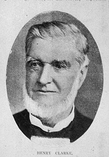
Henry Clarke was an Australian businessman and politician in the New South Wales Legislative Assembly.

Gloucester County, New South Wales Cadastral in New South Wales, Australia

Gloucester County was one of the original Nineteen Counties in New South Wales, and is now one of the 141 cadastral divisions of New South Wales. It includes the area around Port Stephens. It is bounded on the north and west by the Manning River, and on the south-west by the Williams River.

Northumberland County, New South Wales Cadastral in New South Wales, Australia

Northumberland County was one of the original Nineteen Counties in New South Wales and is now one of the 141 Cadastral divisions of New South Wales. It included the area to the north of Broken Bay, including Lake Macquarie and Newcastle(Greater Newcastle). It was bounded by the part of the Hawkesbury River to the south, the Macdonald River to the south-west, and the Hunter River to the north.

Camden County, New South Wales Cadastral in New South Wales, Australia

Camden County was one of the original Nineteen Counties in New South Wales and is now one of the 141 Cadastral divisions of New South Wales. It included the coastal area near Wollongong south to the Shoalhaven River, and also inland encompassing Berrima and Picton. Its western boundary was the Wollondilly River. The first settlement in the area was Camden Park, established by John Macarthur in 1806, just across the Nepean River from Cumberland County. It was the first land across the Nepean to be settled. Camden is a present-day suburb of Sydney in the same area, although parts of it are in Cumberland.

St Vincent County Cadastral in Australian Capital Territory

St Vincent County was one of the original Nineteen Counties in New South Wales and is now one of the 141 Cadastral divisions of New South Wales. It included the south coast area encompassing Batemans Bay, Ulladulla, Jervis Bay and inland to Braidwood. The Shoalhaven River is the boundary to the north and west, and the Deua River the boundary to the south.

Blaxland County Cadastral in New South Wales, Australia

Blaxland County is one of the 141 Cadastral divisions of New South Wales. It is bounded to the south by the Lachlan River and a small part of Waverley Creek. It includes Mount Hope and the Nombinnie Nature Reserve.

Cowper County Cadastral in New South Wales, Australia

Cowper County, New South Wales is one of the 141 Cadastral divisions of New South Wales.

Kennedy County Cadastral in New South Wales, Australia

Kennedy County is one of the 141 Cadastral divisions of New South Wales. It is located to the west of the Bogan River in the area around Tottenham and Tullamore.

Mootwingee County Cadastral in New South Wales, Australia

Mootwingee County, New South Wales is one of the 141 cadastral divisions of New South Wales.

Oxley County Cadastral in New South Wales, Australia

Oxley County, New South Wales is one of the 141 Cadastral divisions of New South Wales. It is located between the Bogan River on the west, and the Macquarie River on the east. This is the area approximately between Warren and Nyngan.

Nerrigundah, New South Wales City in New South Wales, Australia

Nerrigundah is a small village on the Eurobodalla Nature Coast in south eastern New South Wales. Situated at the head of the Tuross River Valley, it is nineteen kilometres inland from Bodalla. At the 2016 census, Nerrigundah had a population of 25.

Cobrabald River River in New South Wales, Australia

Cobrabald River, a mostly perennial river that is part of the Namoi catchment within the Murray–Darling basin, is located in the Northern Tablelands district of New South Wales, Australia.

Mount Wellington (New York) Mountain located in New York State

Mount Wellington is a mountain located in the Central New York Region of New York. It is located south of the Hamlet of Springfield Center at the northern end of Otsego Lake. Mount Wellington rises 600 feet (180 m) above lake level. The extreme southern point of the mountain is called Clarke Point and also referred to as the Shad Cam. It is known as "The Sleeping Lion", as it looks similar to a lion laying down, viewed from Cooperstown, New York. It was originally named Mount Millington, but was renamed by George Hyde Clarke in honor of Field Marshal The 1st Duke of Wellington, the victor of Waterloo, who had been Clarke's schoolmate at Eton College in England.

Jingera Town in New South Wales, Australia

Jingera is a locality in the Snowy Monaro Region, New South Wales, Australia. It lies south of Captains Flat and northeast of Bredbo. At the 2016 census, it had a population of 39. It had a public school from 1889 to 1911 and from 1914 to 1941, often operating "half-time".

References

  1. "Clarke". Geographical Names Register (GNR) of NSW. Geographical Names Board of New South Wales . Retrieved 3 August 2013. OOjs UI icon edit-ltr-progressive.svg