Clarks Beach

Last updated

Clarks Beach
Aerial view of western tip of Clarks Beach.jpg
Aerial view of Clarks Beach
Clarks Beach
Coordinates: 37°08′06″S174°42′07″E / 37.135°S 174.702°E / -37.135; 174.702 Coordinates: 37°08′06″S174°42′07″E / 37.135°S 174.702°E / -37.135; 174.702
Country Flag of New Zealand.svg  New Zealand
Region Auckland Region
Territorial authority Auckland Council
Ward Franklin Ward
Board Franklin Local Board
Population
 (2018)
  Total1,428

Clarks Beach is a small town of Auckland, New Zealand. It is in the former Franklin District local government area.

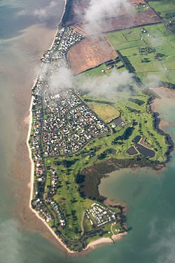
Primarily a beachside rural town, situated within the Manukau Harbour, at the mouth of the Waiuku River, it fronts the harbour and is north facing. It is known as one of the few beaches where scallops can be collected by hand at low tide. It has amazing beaches, and scenery and is a great tourist destination.

About 50 ha immediately to the east of the existing town was rezoned to allow mixed housing in 2016. [1] The Clarks Beach Waterfront Estate development started subsequently in 2019.

Seagrove aerodrome operated near Clarks Beach during World War II.

Demographics

Historical population
YearPop.±% p.a.
20061,368    
20131,359−0.09%
20181,428+1.00%
Source: [2]

Clarks Beach had a population of 1,428 at the 2018 New Zealand census, an increase of 69 people (5.1%) since the 2013 census, and an increase of 60 people (4.4%) since the 2006 census. There were 540 households. There were 705 males and 720 females, giving a sex ratio of 0.98 males per female. The median age was 45.4 years, with 261 people (18.3%) aged under 15 years, 210 (14.7%) aged 15 to 29, 684 (47.9%) aged 30 to 64, and 267 (18.7%) aged 65 or older.

Ethnicities were 91.8% European/Pākehā, 15.1% Māori, 4.2% Pacific peoples, 4.6% Asian, and 1.7% other ethnicities (totals add to more than 100% since people could identify with multiple ethnicities).

The proportion of people born overseas was 20.2%, compared with 27.1% nationally.

Although some people objected to giving their religion, 53.8% had no religion, 33.6% were Christian, and 2.9% had other religions.

Of those at least 15 years old, 204 (17.5%) people had a bachelor or higher degree, and 240 (20.6%) people had no formal qualifications. The median income was $41,700. The employment status of those at least 15 was that 621 (53.2%) people were employed full-time, 156 (13.4%) were part-time, and 27 (2.3%) were unemployed. [2]

Related Research Articles

Auckland is one of the sixteen regions of New Zealand, which takes its name from the eponymous urban area. The region encompasses the Auckland Metropolitan Area, smaller towns, rural areas, and the islands of the Hauraki Gulf. Containing 33 percent of the nation's residents, it has by far the largest population and economy of any region of New Zealand, but the second-smallest land area.

Brighton, New Zealand Settlement in New Zealand

Brighton is a small seaside town within the city limits of Dunedin on New Zealand's South Island. It is located 20 kilometres southwest from the city centre on the Southern Scenic Route. The town faces a small bay which includes a broad sheltered beach. Other beaches extend from here. They make the area popular for summer day trips from Dunedin.

Granity Place in West Coast, New Zealand

Granity is a small town on the West Coast of New Zealand's South Island, 28 kilometres (17 mi) north-east of Westport on State Highway 67. Karamea is 68 kilometres (42 mi) further north.

Whangamatā Town in Waikato, New Zealand

The town of Whangamatā is on the southeast coast of the Coromandel Peninsula in the North Island of New Zealand. It is located 30 kilometres north of Waihi, to the north of the western extremity of the Bay of Plenty.

Aramoana Coastal settlement in Otago, New Zealand

Aramoana is a small coastal settlement 27 kilometres (17 mi) north of Dunedin on the South Island of New Zealand. The settlement's permanent population in the 2001 Census was 261. Supplementing this are seasonal visitors from the city who occupy cribs. The name Aramoana is Māori for "pathway of the sea".

Purau Place in Canterbury Region, New Zealand

Purau is a small town in Canterbury, New Zealand, facing Lyttelton Harbour.

Ōmokoroa Place in Bay of Plenty, New Zealand

Ōmokoroa is a small urban area in the Western Bay of Plenty District of New Zealand. The suburb is considered part of Greater Tauranga, and is within the Coromandel electorate. Ōmokoroa began as a small rural holiday village, but is expanding to be a commuter town, with a 25-minute drive to Tauranga City.

Wallacetown is a small town in Southland, in the South Island of New Zealand. Wallacetown is to the west of Invercargill, on high ground between the Makarewa and Ōreti rivers, near the Ōreti's estuary. Both rivers are popular for trout and whitebait fishing. It is considered to be a satellite town of Invercargill. It is served by State Highway 99, which skirts the town's northern edge.

Broadwood, New Zealand Place in Northland Region, New Zealand

Broadwood is a town about 25 km to the north of the north side of the Hokianga harbour, in Northland, New Zealand. Herekino is 21 km to the west, and Mangamuka Bridge is the same distance to the east.

Te Rerenga is a locality on the Whangapoua Harbour, Coromandel Peninsula, New Zealand. State Highway 25 runs through it. Coromandel is 12 km to the west. Whitianga lies to the south east. The Waitekuri and Opitonui Rivers flow from the Coromandel Range in the west and south through the area to drain in the Whangapoua Harbour.

Whenuakite is a locality on the Coromandel Peninsula of New Zealand. State Highway 25 runs through it. Whitianga is north west, Coroglen 8 km west, Cooks Beach and Hahei north, Hot Water Beach north east, and Tairua 18 km to the south east. The Whenuakite River flows from coastal hills in the east through the area to drain in the Whitianga Harbour.

Mangawhai Place in Northland Region, New Zealand

Mangawhai is a locality in Northland, New Zealand around the Mangawhai Harbour. The township of Mangawhai is at the south west extent of the harbour, and the township of Mangawhai Heads is 5 km north east. Kaiwaka is 13 km south west, and Waipu is 20 km north west of Mangawhai Heads.

Whangarei District Territorial authority in Northland, New Zealand

Whangarei District is a territorial authority district in the Northland Region of New Zealand that is governed by the Whangarei District Council. The district is made up in area largely by rural land, and includes a fifth of the Northland Region. It extends southwards to the southern end of Bream Bay, northwards to Whangaruru and almost to the Bay of Islands, and westwards up the Mangakahia River valley past Pakotai and almost to Waipoua Forest. It includes the Hen and Chicken Islands and the Poor Knights Islands.

The Pines Beach Human settlement in Waimakariri District, Canterbury Region, New Zealand

The Pines Beach is a small town situated roughly 4 km east of Kaiapoi in the Canterbury region of the South Island of New Zealand. It is 1 km north of the mouth of the Waimakariri River. It takes its name from its close proximity to both a pine forest and the beach.

Challis, New Zealand Suburb of Dunedin in Dunedin City Council, New Zealand

Challis is a settlement on the Otago Harbour coast of Otago Peninsula, within the city limits of the New Zealand city of Dunedin. Though officially regarded as a suburb, the isolated nature of Challis means that most locals regard it as a separate settlement within the city limits.

Tai Tapu Place in South Island, New Zealand

Tai Tapu, previously known as Taitapu, is a small town adjacent to the Halswell River and nestled in the Port Hills, located 6 km east of the town of Lincoln and 18 km south west of Christchurch in the Canterbury region of New Zealand's South Island. State Highway 75 passes through the centre of the village, connecting Christchurch with Akaroa and the Banks Peninsula.

Pōhara Settlement in Tasman, New Zealand

Pōhara is a rural locality in the Tasman District of New Zealand's South Island. The locality is northeast of Tākaka and southwest of Tata Beach. To the north is Limestone Bay, part of Golden Bay / Mohua

Te Korowai-o-Te-Tonga Peninsula

Te Korowai-o-Te-Tonga Peninsula, also known as South Head and by its former name of the South Kaipara Peninsula, is a long peninsula in the North Island of New Zealand, extending north along the western edge of the Kaipara Harbour for some 35 kilometres (22 mi) from near Helensville to the harbour's mouth. The peninsula was officially renamed in 2013 as part of a Treaty of Waitangi settlement. The name, which is Māori for "The cloak of the south", reflects the peninsula's geographical role in guarding the southern half of the Kaipara Harbour from the Tasman Sea and prevailing westerly winds. The mouth of the Kaipara Harbour separates the peninsula from the larger Pouto Peninsula to the north.

Waipapakauri is a small settlement in the Far North District of New Zealand. It is located on State Highway 1 at the isthmus of the Aupouri Peninsula. The larger settlement of Awanui lies to the southeast. Waipapakauri is some 12 kilometres to the north of Kaitaia, the nearest town.

Woodend Beach Rural settlement in Canterbury, New Zealand

Woodend Beach is a small rural community in the Waimakariri District, New Zealand.

References

  1. "Rezoning and Residential Subdivision, Clarks Beach". Civil Plan Consultants. Retrieved 15 September 2020.
  2. 1 2 "Statistical area 1 dataset for 2018 Census". Statistics New Zealand. March 2020. Clarks Beach (159400). 2018 Census place summary: Clarks Beach