Clay City, Illinois

Last updated

Clay City
Clay County Illinois Incorporated and Unincorporated areas Clay City Highlighted.svg
Location of Clay City in Clay County, Illinois.
Illinois in United States (US48).svg
Location of Illinois in the United States
Coordinates: 38°41′13″N88°21′11″W / 38.68694°N 88.35306°W / 38.68694; -88.35306
CountryUnited States
StateIllinois
County Clay
Government
  Village presidentRod Franklin [1]
Area
[2]
  Total1.78 sq mi (4.61 km2)
  Land1.78 sq mi (4.61 km2)
  Water0.00 sq mi (0.00 km2)
Population
 (2020)
  Total847
  Density475.31/sq mi (183.56/km2)
Time zone UTC-6 (CST)
  Summer (DST) UTC-5 (CDT)
ZIP Code(s)
62824
Area code 618
FIPS code 17-14715
Wikimedia CommonsClay City, Illinois
Website https://www.villageofclaycityil.com/

Clay City is a village in Clay County, Illinois, United States. The population was 847 at the 2020 census. Clay City was named for the Kentucky statesman Henry Clay. [3]

Contents

Geography

Clay City is located in southeastern Clay County at 38°41′13″N88°21′11″W / 38.68694°N 88.35306°W / 38.68694; -88.35306 (38.686883, -88.353121), [4] about 1 mile (1.6 km) southwest of the Little Wabash River. U.S. Route 50 passes through the southern side of the village, leading west 7 miles (11 km) to Flora and east 15 miles (24 km) to Olney. Louisville, the Clay County seat, is 14 miles (23 km) to the northwest.

According to the 2021 census gazetteer files, Clay City has a total area of 1.78 square miles (4.61 km2), all land. [5]

Demographics

Historical population
CensusPop.Note
1870 594
1880 6123.0%
1900 907
1910 837−7.7%
1920 648−22.6%
1930 7079.1%
1940 1,13660.7%
1950 1,103−2.9%
1960 1,1443.7%
1970 1,049−8.3%
1980 1,038−1.0%
1990 929−10.5%
2000 1,0007.6%
2010 959−4.1%
2020 847−11.7%
U.S. Decennial Census [6]

As of the 2020 census [7] there were 847 people, 356 households, and 239 families residing in the village. The population density was 475.31 inhabitants per square mile (183.52/km2). There were 432 housing units at an average density of 242.42 per square mile (93.60/km2). The racial makeup of the village was 97.52% White, 0.24% Native American, 0.12% Asian, and 2.13% from two or more races. Hispanic or Latino of any race were 0.24% of the population.

There were 356 households, out of which 35.7% had children under the age of 18 living with them, 51.12% were married couples living together, 8.43% had a female householder with no husband present, and 32.87% were non-families. 29.49% of all households were made up of individuals, and 19.38% had someone living alone who was 65 years of age or older. The average household size was 3.07 and the average family size was 2.52.

The village's age distribution consisted of 28.8% under the age of 18, 7.6% from 18 to 24, 25.6% from 25 to 44, 21.8% from 45 to 64, and 16.2% who were 65 years of age or older. The median age was 31.9 years. For every 100 females, there were 82.9 males. For every 100 females age 18 and over, there were 93.9 males.

The median income for a household in the village was $45,104, and the median income for a family was $49,688. Males had a median income of $36,875 versus $21,875 for females. The per capita income for the village was $23,317. About 19.7% of families and 22.1% of the population were below the poverty line, including 39.1% of those under age 18 and 14.5% of those age 65 or over.

History

In the early 1800s Solomon Harter Mueller (later Miller) came to Clay City, IL. with his Cherokee wife (later Ida) and 6 children, from W. Virginia to establish a farm and grinding Mill. He later built a smokehouse, general store and Milinary shop. Solomon also brought his brother George C with wife Caroline and 5 children. Solomon and Ida had children : Isom, Mary, Otto, Roy, Louise and Zella all born in Clay City. Great-grandchildren of Louise: Wallace, and Caroline left Clay City, for St. Louis, Mo. Paul George left for Ohio, and ultimately lost oil and mineral rights in Clay City/C

In 1810 John McCawley and Seth Evans were traveling west from Fort Vincennes along the old Buffalo Trace when one of their horses died. McCawley sent his companion back for another horse. McCawley stayed behind in a cabin built on the west bank of the Little Wabash River just south and east of the future Clay City. This made McCawley the first white man to settle in this area. McCawley later decided to build a stagecoach stop and trading center on the location which was known as McCawley's Tavern. It provided a place for travelers to stop, eat, and spend the night.

Clay County was created by an act of the legislature on December 23, 1824. On Tuesday, March 8, 1825, at John McCawley's place, the first county commissioners' court assembled for the new county of Clay. In 1825 Daniel May donated 20 acres (81,000 m2) of land, just over 2 miles (3 km) west of McCawley's Tavern, to the county for the purpose of constructing a courthouse. This land is one block south of US 50 and to the west of what is now South Main Street. This area had previously been known as Hubbardsville but was renamed Maysville. A two-room courthouse was constructed in 1825, and court was held at Maysville until 1841 when it was moved to the new and present county seat, Louisville.

In 1855, after the O&M Railroad was located about 1 mile (1.6 km) north of Maysville, Clay City was established by Mr. J.D. Perkey on the north side of the tracks and mostly to the east of the present North Main Street. The business district soon developed to the south of the tracks where it is presently located. Maysville was made a part of the Village of Clay City in 1862.

Clay City served as a trading center for the surrounding countryside. Farmers could bring their produce to town and trade it for dry goods, etc. and very little money would change hands. With the passenger trains stopping in Clay City it also served as a source of transportation for the surrounding area. Many of the tourists who traveled to the once famous resort of Sailor Springs would take the train to Clay City and then use local transportation on up to Sailor Springs.

In 1936 oil was discovered in this area, and oil-related businesses continue to thrive in Clay City today. [8]

Notable persons

Related Research Articles

<span class="mw-page-title-main">Clay County, Illinois</span> County in Illinois, United States

Clay County is a county in the southeastern portion of the U.S. state of Illinois. As of the 2020 United States Census, the population was 13,288. Since 1842, its county seat has been Louisville, in the center of the county's area.

<span class="mw-page-title-main">Maysville, Georgia</span> Town in Georgia, United States

Maysville is a town in Banks and Jackson counties in the U.S. state of Georgia. The population was 1,798 at the 2010 census, up from 1,247 at the 2000 census.

<span class="mw-page-title-main">Iola, Illinois</span> Village in Illinois, United States

Iola is a village in Clay County, Illinois, United States. The population was 98 at the 2020 census.

<span class="mw-page-title-main">Louisville, Illinois</span> Village in Illinois, United States

Louisville is a village in Clay County, Illinois, United States, along the Little Wabash River. The population was 1,136 at the 2020 census. It is the county seat of Clay County.

<span class="mw-page-title-main">Sailor Springs, Illinois</span> Village in Illinois, United States

Sailor Springs is a village in Clay County, Illinois, United States. The population was 89 at the 2020 census.

<span class="mw-page-title-main">Xenia, Illinois</span> Village in Illinois, United States

Xenia is a village in Clay County, Illinois, United States. The population was 380 at the 2020 census.

<span class="mw-page-title-main">Browns, Illinois</span> Village in Illinois, United States

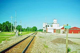
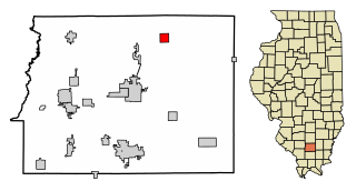
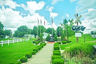
Browns is a village in Edwards County, Illinois, United States. The population was 139 as of the 2020 census, slightly up from 134 as of the 2010 census.

<span class="mw-page-title-main">Edgewood, Illinois</span> Village in Illinois, United States

Edgewood is a village in Effingham County, Illinois, United States. The population was 398 at the 2020 Census. Edgewood is part of the Effingham, IL Micropolitan Statistical Area.

<span class="mw-page-title-main">Ewing, Illinois</span> Village in Illinois, United States

Ewing is a village in Franklin County, Illinois, United States. The population was 300 at the 2020 census.

<span class="mw-page-title-main">New Haven, Illinois</span> Village in Illinois, United States

New Haven is a village in Gallatin County, Illinois, United States, along the Little Wabash River near its mouth at the Wabash River. The population was 399 at the 2020 United States Census, down from 433 at the 2010 United States Census.

<span class="mw-page-title-main">Hillview, Illinois</span> Village in Illinois, United States

Hillview is a village in Greene County, Illinois, United States. The population was 94 at the 2020 census.

<span class="mw-page-title-main">Elizabethtown, Illinois</span> Village in Illinois, United States

Elizabethtown is a village in and the county seat of Hardin County, Illinois, United States, along the Ohio River. The population was 299 at the 2010 census, down from 348 at the 2000 census. It is the least-populous county seat in the state.

<span class="mw-page-title-main">Leland, Illinois</span> Village in Illinois, United States

Leland is a village in LaSalle County, Illinois, United States. The population was 951 at the 2020 census. It is part of the Ottawa Micropolitan Statistical Area.

<span class="mw-page-title-main">Crossville, Illinois</span> Village in Illinois, United States

Crossville is a village in White County, Illinois, United States. The population was 745 at the 2010 census.

<span class="mw-page-title-main">Maunie, Illinois</span> Village in Illinois, United States

Maunie is a village in White County, Illinois, United States. The population was 177 at the 2000 census.

<span class="mw-page-title-main">Symerton, Illinois</span> Village in Illinois, United States

Symerton is a village in Will County, Illinois, United States. The population was 128 at the 2020 census. By population, it is the smallest village in Will County.

<span class="mw-page-title-main">West Terre Haute, Indiana</span> Town in Indiana, United States

West Terre Haute is a town in Sugar Creek Township, Vigo County, Indiana, on the western side of the Wabash River near Terre Haute. The population was 2,236 at the 2010 census. It is part of the Terre Haute Metropolitan Statistical Area. Bethany Congregational Church was placed on the National Register of Historic Places in 2003.

<span class="mw-page-title-main">Carlisle, Kentucky</span> City in Kentucky, United States

Carlisle is a home rule-class city in Nicholas County, Kentucky, United States. The population was 2,010 at the 2010 census. It is the county seat of Nicholas County. It is located at the junction of Kentucky Route 32 and Kentucky Route 36, about halfway between Lexington and Maysville.

<span class="mw-page-title-main">Mooringsport, Louisiana</span> Town in Louisiana, United States

Mooringsport is an incorporated municipality in the U.S. state of Louisiana, located in Caddo Parish. Part of the Shreveport–Bossier City metropolitan area and located approximately 18 miles (29 km) outside of the principal city of Shreveport, the town of Mooringsport had a population of 748 at the 2020 U.S. census.

<span class="mw-page-title-main">Zwingle, Iowa</span> City in Iowa, United States

Zwingle is a city in Dubuque and Jackson counties in the U.S. state of Iowa. The population was 84 at the time of the 2020 census, down from 100 in 2000.

References

  1. "Incorporated Cities, Towns & Villages of Illinois" (PDF). Illinois Blue Book (2021-2022 ed.). Springfield. ISSN   0191-104X. OCLC   1645571.
  2. "2020 U.S. Gazetteer Files". United States Census Bureau. Retrieved March 15, 2022.
  3. Gannett, Henry (1905). The Origin of Certain Place Names in the United States. Govt. Print. Off. pp.  84.
  4. "US Gazetteer files: 2010, 2000, and 1990". United States Census Bureau. February 12, 2011. Retrieved April 23, 2011.
  5. Bureau, US Census. "Gazetteer Files". Census.gov. Retrieved June 29, 2022.
  6. "Census of Population and Housing". Census.gov. Retrieved June 4, 2015.
  7. "Explore Census Data". data.census.gov. Retrieved June 28, 2022.
  8. "Larry Brant - Village of Clay City". Archived from the original on February 28, 2009. Retrieved March 24, 2009.