
Malacca Strait is a narrow stretch of water, 500 mi long and from 40 to 155 mi wide, located between the Indonesian island of Sumatra to the southwest and the Malay Peninsula to the northeast, connecting the Andaman Sea with the Singapore Strait and the South China Sea. As the main shipping channel between the Indian Ocean and the South China Sea, it is one of the most important shipping lanes in the world. It is named after the Phyllanthus emblica, which is known by the locals as the Malaka tree, grown in coastal regions alongside the strait.
A causeway is a track, road or railway on the upper point of an embankment across "a low, or wet place, or piece of water". It can be constructed of earth, masonry, wood, or concrete. One of the earliest known wooden causeways is the Sweet Track in the Somerset Levels, England, which dates from the Neolithic age. Timber causeways may also be described as both boardwalks and bridges.

The East Coast Parkway is an expressway that runs along the southeastern coast of Singapore. It is approximately 20 kilometres (12 mi) in length. As of July 2022, it is Singapore's third-longest expressway.

The Merlion is the official mascot of Singapore. It is depicted as a mythical creature with the head of a lion and the body of a fish. Being of prominent symbolic nature to Singapore and Singaporeans in general, it is widely used to represent both the city state and its people in sports teams, advertising, branding, tourism and as a national personification.

A single-point urban interchange, also called a single-point interchange (SPI) or single-point diamond interchange (SPDI), is a type of highway interchange. The design was created in order to help move large volumes of traffic through limited amounts of space efficiently.

The Central Expressway (CTE) in Singapore is the major highway connecting the city centre of Singapore with the northern residential parts of the island, including Toa Payoh, Bishan and Ang Mo Kio and further onwards to the Seletar Expressway and the Tampines Expressway.

The Singapore River is a river that flows parallel to Alexandra Road and feeds into the Marina Reservoir in the southern part of Singapore. The immediate upper watershed of the Singapore River is known as the Singapore River Planning Area, although the western part of the watershed is classified under the River Valley planning area.

Clarke Quay is a historical riverside quay in Singapore, located within the Singapore River Planning Area. The quay is situated upstream from the mouth of the Singapore River and Boat Quay.

Geylang Road is a major trunk road linking Singapore's eastern suburban areas with the country's central business district. Deriving its name from the area of Geylang where the road cuts through, it is fronted on both sides by low-rise shophouses protected statutorily from urban redevelopment in keeping with its history and urban heritage.
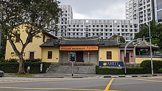
The House of Tan Yeok Nee is a mansion building located at the junction of Penang Road and Clemenceau Avenue in the Museum Planning Area in Singapore. After an extensive restoration completed in 2000, it was held by the University of Chicago Booth School of Business. As of 2019, the building serves as the Singapore campus for Amity Global Institute.
The Esplanade Bridge is a 261-metre-long (850 ft.) road bridge that spans across the mouth of the Singapore River in Singapore with the Esplanade - Theatres on the Bay on its northern abutment and the Merlion on the southern. The 70 metre-wide (230 ft.) low-level concrete arched bridge has seven spans and supports two four-lane carriageways and walkways along both sides.

The Expressway Monitoring and Advisory System, also known by its acronym of EMAS, is a computerised system that is used to monitor traffic on Singapore's expressways. EMAS enables Land Transport Authority (LTA) personnel to detect accidents and respond to them more quickly. In addition, it notifies motorists of adverse traffic conditions.

The Museum Planning Area is a planning area located in the Central Area of the Central Region of Singapore. The area plays a "bridging role" between the Orchard area and the Downtown Core, which necessitates proper transport networks for vehicles, pedestrians and public transport. Due to the sheer size of green areas in the district, the Urban Redevelopment Authority (URA) has designated it a 'green lung' in the Central Area. However, the Museum Planning Area is also home to cultural and commercial activities. Around 65% of the area is available for future development, making it a hotbed for new infrastructure and buildings.

Ord Bridge is a pedestrian bridge in Singapore. It spans the Singapore River at Clarke Quay, located in the Singapore River Planning Area within the Central Area.

Coleman Bridge is a vehicular bridge in Singapore. The bridge links Hill Street and New Bridge Road, spanning the Singapore River near Clarke Quay. Part of the bridge demarcates the boundary between the Downtown Core and the Singapore River Planning Area, both of which are located within the Central Area.

Nicoll Highway is a major arterial road in Singapore which links the junctions of Guillemard Road, Sims Way and Mountbatten Road in Kallang to the junctions of Esplanade Drive, Raffles Avenue and Stamford Road in the city. En route, it passes through the areas of Kallang, Kampong Glam and Marina Centre.

The Rochor River is a canalised river in Kallang of the Central Region in Singapore. The river is about 0.8 km in length.

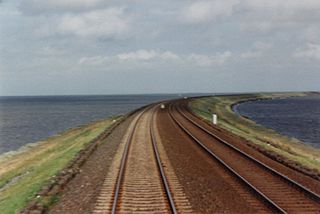
The Sultan Iskandar Building is a customs, immigration and quarantine (CIQ) complex in Johor Bahru, Johor, Malaysia. Located at the northern end of the Johor–Singapore Causeway, it is one of two land ports of entry to Malaysia on the Malaysia–Singapore border.
The Mandai Wildlife Bridge is an ecological bridge in Singapore. It links portions of the Central Catchment Nature Reserve that are otherwise separated by the Mandai Lake Road.
