
Orkney, also known as the Orkney Islands, is an archipelago in the Northern Isles of Scotland, situated off the north coast of the island of Great Britain. Orkney is 10 miles (16 km) north of the coast of Caithness and has about 70 islands, of which 20 are inhabited. The largest island, Mainland, is often referred to as "the Mainland", and has an area of 523 square kilometres (202 sq mi), making it the sixth-largest Scottish island and the tenth-largest island in the British Isles. Orkney’s largest settlement, and also its administrative centre, is Kirkwall.
Firth is a word in the English and Scots languages used to denote various coastal waters in the United Kingdom, predominantly within Scotland. In the Northern Isles, it more usually refers to a smaller inlet. It is linguistically cognate to fjord which has a more constrained sense in English. Bodies of water named "firths" tend to be more common on the Scottish east coast, or in the southwest of the country, although the Firth of Clyde is an exception to this. The Highland coast contains numerous estuaries, straits, and inlets of a similar kind, but not called "firth" ; instead, these are often called sea lochs. Before about 1850, the spelling "Frith" was more common.

Caithness is a historic county, registration county and lieutenancy area of Scotland.
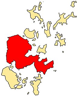
The Mainland, also known as Hrossey and Pomona, is the main island of Orkney, Scotland. Both of Orkney's burghs, Kirkwall and Stromness, lie on the island, which is also the heart of Orkney's ferry and air connections.
The Out Skerries are an archipelago of islets, some inhabited, in Shetland, Scotland, and are the easternmost group of Shetland's islands. Locally, they are usually called Da Skerries or just Skerries.

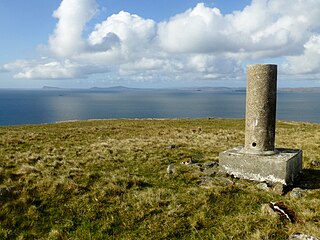
Dunnet Head is a peninsula in Caithness, on the north coast of Scotland. Dunnet Head includes the most northerly point of both mainland Scotland and the island of Great Britain.
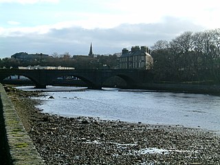
Wick is a town and royal burgh in Caithness, in the far north of Scotland. The town straddles the River Wick and extends along both sides of Wick Bay. "Wick Locality" had a population of 6,954 at the time of the 2011 census, a decrease of 3.8% from 2001.
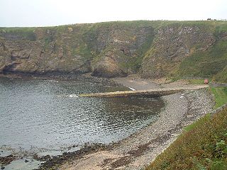
Thurso Bay, known also as Scrabster Bay, is a bay of Atlantic water between the points of Clairdon Head and Holborn Head on the north coast of Caithness, Scotland.
Holborn Head is a headland on the north-facing Atlantic coast of Caithness, in the Highland area of Scotland. The point of Holborn Head is at 58°37′23″N03°32′06″W. It has a lighthouse at its south end and the remains of an old fort at its tip.

Skarfskerry is a settlement located in the far northern county Caithness on a small peninsula northeast of Thurso off the A836 in Scotland. It is the most northerly settlement in Great Britain. The name comes from the Old Norse for "cormorants' rock". Historically, it belonged to the Parish of Dunnet, along with Brough.
Linga is a small, uninhabited island, 1 km (0.62 mi) east of Muckle Roe in the Shetland Islands. The island is roughly circular in shape and its highest elevation is 69 metres (226 ft). Its area is 70 hectares (0.27 sq mi).
West Linga is an uninhabited island located between Mainland and Whalsay in Shetland, Scotland.
The Orcadian Basin is a sedimentary basin of Devonian age that formed mainly as a result of extensional tectonics in northeastern Scotland after the end of the Caledonian orogeny. During part of its history, the basin was filled by a lake now known as Lake Orcadie. In that lacustrine environment, a sequence of finely bedded sedimentary rocks was deposited, containing well-preserved fish fossils, with alternating layers of mudstone and coarse siltstone to very fine sandstone. These flagstones split easily along the bedding and have been used as building material for thousands of years. The deposits of the Orcadian Basin form part of the Old Red Sandstone (ORS). The lithostratigraphic terms lower, middle and upper ORS, however, do not necessarily match exactly with sediments of lower, middle and upper Devonian age, as the base of the ORS is now known to be in the Silurian and the top in the Carboniferous.
Brough is a small village in Caithness in the North of Scotland. It is located on the B855 single-track road, the most northerly numbered road on the mainland of Great Britain, and is a few miles to the south east of Dunnet Head, the most northerly point on the British mainland, and a mile or so north of the village of Dunnet. Brough is the site of Brough Castle, a twelfth Century Norse fortress; the ruins are on the property now known as Heathcliff. Brough is the most northerly village on the British mainland.
Clate is a hamlet and ward in southwestern Whalsay in the parish of Nesting in the Shetland Islands of Scotland.

Linga Sound is the strait between the islands of Whalsay and West Linga in the Shetland islands of Scotland.
The Northern European Enclosure Dam (NEED) is a proposed solution to the problem of rising ocean levels in Northern Europe. It would be a megaproject, involving the construction of two massive dams in the English Channel and the North Sea; the former between France and England, and the latter between Scotland and Norway. The concept was conceived by the oceanographers Sjoerd Groeskamp and Joakim Kjellsson.
