Cleveland Street, London

Last updated

Cleveland Street
BTTowerfromClevelandStreet.jpg
A view of Cleveland Street looking south from the intersection with Greenwell Street (previously Buckingham Street), featuring the BT Tower
Namesake Charles FitzRoy, 2nd Duke of Cleveland
Length0.4 mi (0.64 km)
Postal code W1
Nearest Tube station Underground no-text.svg Great Portland Street
Coordinates 51°31′15″N0°08′21″W / 51.520867°N 0.139196°W / 51.520867; -0.139196
north end Euston Road
south endGoodge Street

Cleveland Street in central London runs north to south from Euston Road (A501) to the junction of Mortimer Street and Goodge Street. It lies within Fitzrovia, in the W1 post code area. Cleveland Street also runs along part of the border between Bloomsbury (ward) which is located in London Borough of Camden, and West End (ward) in the City of Westminster. [1] In the 17th century, the way was known as the Green Lane, when the area was still rural, or Wrastling Lane, after a nearby amphitheatre for boxing and wrestling. [2]

Contents

Geography

Cleveland Street as seen on Greenwood's map of the area in the late 1820s Map Great Portland Street Greenwood 1827.JPG
Cleveland Street as seen on Greenwood's map of the area in the late 1820s
Area before Cleveland Street (Norfolk St) was laid out in 1774 Area prior to Norfolk Road (later Cleveland Street) being laid out in 1774.jpg
Area before Cleveland Street (Norfolk St) was laid out in 1774
Cleveland Street Work House London Cleveland Street Work House London.jpg
Cleveland Street Work House London
Cleveland Street Conservation Area Cleveland Street Conservation Area.jpg
Cleveland Street Conservation Area

Cleveland Street marks the border between the City of Westminster to its west and the London Borough of Camden to the east. This border is ancient, largely following the old divide between the western parish of Saint Marylebone and the parish of Saint Pancras to the east and can be traced back as far as 1792. [4] The street was also a boundary between large estates, such as the Bedford Estate and the Berners Estate. [5] Maps show that the southern end of modern Cleveland Street, beyond Riding House Street, was known as Upper Newman Street and then Norfolk Street. The northern section was once known as Upper Cleveland Street and Buckingham Place. [6]

It became Cleveland Street for its full length after a renumbering was ordered by the Metropolitan Board of Works in 1867. [7]

The name comes from the Charles FitzRoy, 2nd Duke of Cleveland whose estate was connected in the 19th century with the Southampton (Wriothesley) property [8] via Henry Fitzroy, 1st Duke of Grafton. The Southampton property later became the Bedford Estate.

Cleveland Street is renowned for several historical events and buildings, the most notable recent one being the BT Tower.

History

The street is most notably associated with the Cleveland Street Scandal of 1889-90, which involved a male brothel in a terrace house at Number 19 (long demolished). [9] The scandal was rumoured to involve the heir-presumptive to the throne, Prince Albert Victor, Duke of Clarence and Avondale, but the allegation has never been substantiated. [10]

Notable buildings

The Grade II listed buildings are numbers: [11]

The Cleveland Street Workhouse [19] is of particular importance in light of the fact that Charles Dickens is known to have lived nearby in what is now 22 Cleveland Street. Dickens lived there as a young child between 1815 and 1816 and then again as a teenager between 1828 and 1831. His residence in the street has led to the suggestion that the nearby workhouse was probably the inspiration for Oliver Twist. [20] [21]

Cleveland Street hosted the Middlesex Hospital, closed in 2005 and since demolished. The hospital occupied an entire block on the western side of the southern section of the street. The future of this site is currently uncertain, despite its sale by nationalised Icelandic Kaupthing Bank to Aviva Investors and Exemplar Properties. [22]

Cleveland Street was described as an area of special architectural and historic interest when it was designated a Conservation Area on 20 November 1990. [23] Anomalously on its Camden side Cleveland Street is part of two conservation areas: the Fitzroy Square conservation area, [24] and the Charlotte Street conservation area. [25] This double designation is rare and possibly unique.

See also

Related Research Articles

<span class="mw-page-title-main">West End of London</span> Area of Central London, England

The West End of London is a district of Central London, London, England, west of the City of London and north of the River Thames, in which many of the city's major tourist attractions, shops, businesses, government buildings and entertainment venues, including West End theatres, are concentrated.

<span class="mw-page-title-main">Paddington</span> Area of central London, England

Paddington is an area in the City of Westminster, in central London, England. A medieval parish then a metropolitan borough, it was integrated with Westminster and Greater London in 1965. Paddington station, designed by the engineer Isambard Kingdom Brunel opened in 1847. It is also the site of St Mary's Hospital and the former Paddington Green Police Station.

<span class="mw-page-title-main">Islington</span> District of London, England

Islington is a district in the north of Greater London, England, and part of the London Borough of Islington. It is a mainly residential district of Inner London, extending from Islington's High Street to Highbury Fields, encompassing the area around the busy High Street, Upper Street, Essex Road, and Southgate Road to the east.

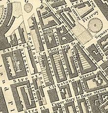
Somers Town is an inner-city district in North West London. It has been strongly influenced by the three mainline north London railway termini: Euston (1838), St Pancras (1868) and King's Cross (1852), together with the Midland Railway Somers Town Goods Depot (1887) next to St Pancras, where the British Library now stands. It was named after Charles Cocks, 1st Baron Somers (1725–1806). The area was originally granted by William III to John Somers (1651–1716), Lord Chancellor and Baron Somers of Evesham.

<span class="mw-page-title-main">Fitzrovia</span> Human settlement in England

Fitzrovia is a district of central London, England, near the West End. The eastern part of area is in the London Borough of Camden, and the western in the City of Westminster. It has its roots in the Manor of Tottenham Court, and was urbanised in the 18th century. Its name was coined in the late 1930s by Tom Driberg.

<span class="mw-page-title-main">Metropolitan Borough of St Marylebone</span> Metropolitan borough of England

The Metropolitan Borough of St Marylebone was a metropolitan borough of the County of London from 1900 to 1965. It was based directly on the previously existing civil parish of St Marylebone, Middlesex, which was incorporated into the Metropolitan Board of Works area in 1855, retaining a parish vestry, and then became part of the County of London in 1889.

<span class="mw-page-title-main">Swiss Cottage</span> Area of Hampstead in London, England

Swiss Cottage is an area of Hampstead in the London Borough of Camden, England. It is centred on the junction of Avenue Road and Finchley Road and includes Swiss Cottage tube station. Swiss Cottage lies 3.25 miles (5.23 km) north-northwest of Charing Cross. The area was named after a public house in the centre of it, known as "Ye Olde Swiss Cottage".
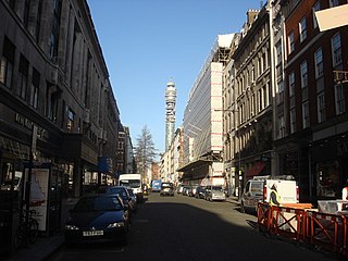
<span class="mw-page-title-main">Great Portland Street</span>

Great Portland Street in Marylebone, in the West End of London, links Oxford Street with the A501 Marylebone Road. A commercial street, it divides Fitzrovia, to the east, from Marylebone to the west. It delineates areas with contrasting identities, the west at strongest in grandiose Portland Place and Harley Street, the east at strongest in artists' and independent businesses of Fitzrovia. Administratively, the street lies in the City of Westminster's West End ward.

<span class="mw-page-title-main">Great Titchfield Street</span>

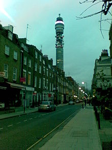
Great Titchfield Street is a street in the West End of London. It runs north from Oxford Street to Greenwell Street, just short of the busy A501 Marylebone Road and Euston Road. It lies within the informally designated London area of Fitzrovia. In administrative terms it is in the City of Westminster. It lies within their designated East Marylebone Conservation Area in the former Metropolitan Borough of St Marylebone.

<span class="mw-page-title-main">Charlotte Street</span>

Charlotte Street is a street in Fitzrovia, historically part of the parish and borough of St Pancras, in central London. It has been described, together with its northern and southern extensions, as the spine of Fitzrovia.
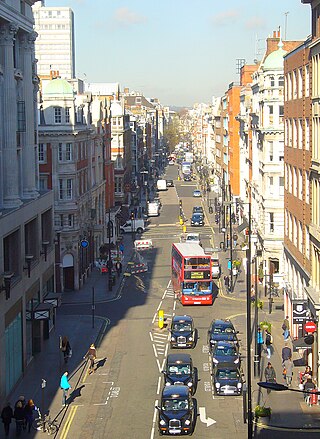
<span class="mw-page-title-main">Marylebone</span> Area in London, England

Marylebone is a district in the West End of London, in the City of Westminster. Oxford Street forms its southern boundary.

<span class="mw-page-title-main">Hallam Street</span>

Hallam Street is a road situated in the Parish of St Marylebone and London's West End. In administrative terms it lies within the City of Westminster's West End Ward as well as the Harley Street Conservation Area. Formerly named both Charlotte Street and Duke Street, it was renamed in the early 1900s after Henry Hallam (1777–1859), a noted historian who had been a local resident, and his son Arthur Henry Hallam (1811–1833), poet and the subject of Tennyson's elegy In Memoriam.

<span class="mw-page-title-main">Bolsover Street</span> Street in City of Westminster, United Kingdom

Bolsover Street is in the Parish of St Marylebone in London's West End. In administrative terms it lies within the City of Westminster's West End Ward and is partly in the Harley Street Conservation Area whilst also sitting on the edges of the Regents Park and East Marylebone Conservation Areas.

<span class="mw-page-title-main">Cleveland Street Workhouse</span> Workhouse in London, England

The Cleveland Street Workhouse is a Georgian property in Cleveland Street, Marylebone, built between 1775 and 1778 for the care of the sick and poor of the parish of St Paul Covent Garden under the Old Poor Law. From 1836, it became the workhouse of the Strand Union of parishes. The building remained in operation until 2005 after witnessing the complex evolution of the healthcare system in England. After functioning as a workhouse, the building became a workhouse infirmary before being acquired by the Middlesex Hospital and finally falling under the NHS. In the last century it was known as the Middlesex Hospital Annexe and the Outpatient Department. It closed to the public in 2005 and it has since been vacated. On 14 March 2011 the entire building became Grade II Listed. Development of the site began in 2019 by current owner University College London Hospitals (UCLH) Charity as a mixed-use development including residential, commercial and open space, but construction has been held up by the necessity to remove human remains stemming from the use of the area around the workhouse as a parish burial ground between 1780 and 1853. There has also been controversy about the amount of social housing to be included in the development.

<span class="mw-page-title-main">Berners Street</span> Street in Westminster, London, United Kingdom

Berners Street is a thoroughfare located to the north of Oxford Street in the City of Westminster in the West End of London, originally developed as a residential street in the mid-18th century by property developer William Berners, and later devoted to larger commercial and semi-industrial buildings or mansion blocks of flats. It has associations with Charles Dickens, and was the location of makers of musical instruments including pianos and harps, as well as furniture and film-makers.

<span class="mw-page-title-main">Weymouth Street</span> Street in the City of Westminster, London, England

Weymouth Street lies in the Marylebone district of the City of Westminster and connects Marylebone High Street with Great Portland Street. The area was developed in the late 18th century by Henrietta Cavendish Holles and her husband Edward Harley, 2nd Earl of Oxford. This part of Marylebone was noted to part of Manor of Tyburn and dates back to the year 1086.

<span class="mw-page-title-main">Greenwell Street</span> Street in the City of Westminster, London

Greenwell Street, formerly Buckingham Street, is located in the Fitzrovia district of the City of Westminster in London. It was built in the late eighteenth century and runs between Bolsover Street in the east and Cleveland Street in the west. Great Titchfield Street joins it on its south side. On the south side is the grade II listed George and Dragon public house (c.1850) and the site of the home of the sculptor John Flaxman, the location of which is marked by a plaque.

<span class="mw-page-title-main">Homer Street</span> One-way street in Westminster

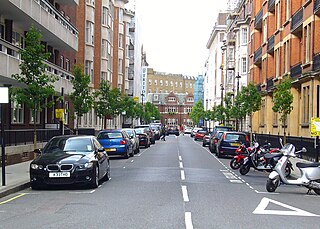
Homer Street is a quiet one-way street in the Marylebone neighbourhood of the City of Westminster, London. It runs from Old Marylebone Road in the north to Crawford Street in the south. The street is part of the Marylebone Ward of Westminster City Council. Its postcode is W1H.

<span class="mw-page-title-main">Margaret Street, London</span> Street in the City of Westminster, London

Margaret Street is a street that straddles the Marylebone and Fitzrovia areas of the City of Westminster in the West End of London, running from Cavendish Square to Wells Street via Regent Street (A4201), Great Portland Street, and Great Titchfield Street. It is north of and parallel to the major shopping street, Oxford Street. John Prince's Street runs between Margaret Street and Oxford Street.

References

  1. "Welcome to Westminster.gov.uk". Westminster.gov.uk. 27 May 2014. Archived from the original on 28 March 2012. Retrieved 28 March 2016.
  2. "Marylebone and its Manors", Transactions of the London and Middlesex Archaeological Society, 4: 64, 1918
  3. Samuel Grimm Illustration dated 1701-2
  4. "Richard Horwood's Plan of London and Westminster 1792". Archived from the original on 20 February 2010. Retrieved 21 May 2010.
  5. Survey of London: volume 36: Covent Garden (1970), pp. 34-37
  6. Horwood Map Archived 20 February 2010 at the Wayback Machine (1792-1799), Peter Potter Map (1832), George Lucas Map of Maylebone (1846), Map of the Parish of St. Marylebone (1832) at Westminster City Archives
  7. "Minutes of Proceedings of the Metropolitan Board of Works - Metropolitan Board of Works (London, England)". 1867. p. 980. Retrieved 28 March 2016.
  8. Survey of London: volume 21: The parish of St Pancras part 3: Tottenham Court Road & neighbourhood (1949), pp. 1-6
  9. Theo Aronson, Prince Eddy and the Homosexual Underworld (1994) pp. 8–10 and Montgomery Hyde, The Cleveland Street Scandal (1976), pp. 20–23
  10. Lees Milne, Harold Nicolson (1980-81), pp.231
  11. National Heritage List Archived 1 May 2012 at the Wayback Machine - List Entry numbers 1356766, 1356767, 1356769, 1356771, 1219525, 1066258, 1291411, 1066259, 1219538 and 1242917
  12. "Plaque unveiled to identify Charles Dickens first London home". Fitzrovia News. 10 June 2013. Retrieved 28 March 2016.
  13. "GEORGE AND DRAGON PUBLIC HOUSE, non Civil Parish - 1219538 | Historic England".
  14. "BT Tower, London". SkyscraperPage.com. Retrieved 28 March 2016.
  15. "Archived copy". Archived from the original on 11 January 2011. Retrieved 22 January 2011.{{cite web}}: CS1 maint: archived copy as title (link)
  16. Camden Council, Details Page for Planning Application - 2010/2205/P Archived 17 March 2012 at the Wayback Machine
  17. Camden Council, Details Page for Planning Application - 2010/2209/C Archived 17 March 2012 at the Wayback Machine
  18. Westminster City Council, Decision document [ permanent dead link ] 1. The City Council considers that the existing building is a heritage asset which makes a positive contribution to the character and appearance of the area. The proposed development would not preserve or enhance this character and appearance. The City Council considers that retention and refurbishment of all or a substantial part of the existing building should be pursued.

    2. The proposals provide insufficient on-street car parking facilities for the development, particularly for the private housing market which would generate significant car parking demand. This would increase the pressure for car parking on surrounding streets to the detriment of highway safety and convenience.

    3. The submitted Daylight, Sunlight and Shadow study shows that the proposed development would result in unacceptable losses of daylight for some of the residential properties on Cleveland Street which face the application site. This would be materially harmful to the local residential environment and lead to an unacceptable reduction in the quality of residential amenity. Retrieved 2011-07-26
  19. "The Cleveland Street Workhouse". The Cleveland Street Workhouse. Archived from the original on 18 February 2011. Retrieved 28 March 2016.
  20. Lorna Bradbury (20 January 2011) "Oliver Twist's Workhouse Discovered", The Telegraph
  21. Richardson, Ruth. Dickens and the Workhouse: Oliver Twist And The London Poor (2012)
  22. Deirdre Hipwell (18 July 2010), "Aviva wins Noho Square scheme", Independent on Sunday
  23. "Department of Planning and City Development, Westminster City Council, Cleveland Street Conservation Area Audit" (PDF). 11 April 2006. Retrieved 14 December 2010.
  24. [ dead link ]
  25. [ dead link ]