Clinton, Queensland

Last updated

Clinton
Gladstone,  Queensland
Australia Queensland location map.svg
Red pog.svg
Clinton
Clinton, Queensland
Coordinates 23°52′29″S151°13′04″E / 23.8748°S 151.2177°E / -23.8748; 151.2177 (Clinton (town centre))
Population6,170 (2021 census) [1]
 • Density995/km2 (2,577/sq mi)
Postcode(s) 4680
Area6.2 km2 (2.4 sq mi)
Time zone AEST (UTC+10:00)
Location
LGA(s) Gladstone Region
State electorate(s) Gladstone
Federal division(s) Flynn
Suburbs around Clinton:
Callemondah Callemondah West Gladstone
Byellee Clinton Kin Kora
Byellee Kirkwood New Auckland

Clinton is a town and suburb of Gladstone in the Gladstone Region, Queensland, Australia. [2] [3] In the 2021 census, the suburb of Clinton had a population of 6,170 people. [4]

Contents

History

The town was named on 5 January 1970. [2] On 10 December 1988 the suburb of Clinton was created from the merger of the former suburbs Clinton North and Clinton South. The name Clinton is derived from the County of Clinton (the cadastral administrative division containing Gladstone). [3]

Clinton State School opened on 29 January 1974. [5] [6]

On 1 April 2010, a Priority Development Area was declared in Clinton with the aim of reducing housing pressure created with the growing mining industry in the Gladstone area. 26 hectares (64 acres) of government land bounded by the Dawson Highway, Harvey Road and Keppel Avenue were released for residential land development. [7]

In the 2011 census, Clinton had a population of 5,917 people. [8]

In the 2016 census, the suburb of Clinton had a population of 5,921 people. [9]

The 2021 census revealed that the population of Clinton had risen to 6,170 people. [10]

Education

Clinton State School is a government primary (Early Childhood-6) school for boys and girls at Harvey Road ( 23°52′48″S151°13′22″E / 23.8800°S 151.2228°E / -23.8800; 151.2228 (Clinton State School) ). [11] [12] In 2015, the school had 820 students with 51 teachers (44 equivalent full-time). [13] In 2018, the school had an enrolment of 950 students with 70 teachers (63 full-time equivalent) and 54 non-teaching staff (31 full-time equivalent). [14] It includes a special education program. [11] [15]

Facilities

Gladstone Airport is on Aerodrome Road ( 23°52′09″S151°13′27″E / 23.8691°S 151.2243°E / -23.8691; 151.2243 (Gladstone Airport) ). [16]

The Port Curtis Lawn Cemetery is on Aerodrome Road ( 23°52′03″S151°12′49″E / 23.8675°S 151.2136°E / -23.8675; 151.2136 (Lawn Cemetery) ). It provides lawn graves for burials and a columbarium wall and memorial garden for the interment of cremains. [17] [18]

Related Research Articles

<span class="mw-page-title-main">Seventeen Seventy, Queensland</span> Town in Queensland, Australia

Seventeen Seventy, sometimes inaccurately written as 1770 or Town of 1770, is a coastal town and locality in the Gladstone Region, Queensland, Australia. In the 2021 census, the locality of Seventeen Seventy had a population of 125 people.

<span class="mw-page-title-main">Boyne Valley, Queensland</span> Suburb of Gladstone Region, Queensland, Australia

The Boyne Valley is a rural locality in Gladstone Region, Queensland, Australia. The locality contains four small towns: Nagoorin, Ubobo, Builyan, and Many Peaks. In the 2021 census, Boyne Valley had a population of 301 people.

<span class="mw-page-title-main">Jambin, Queensland</span> Town in Queensland, Australia

Jambin is a rural town and locality in the Shire of Banana, Queensland, Australia. In the 2021 census, the locality of Jambin had a population of 207 people.

Turkey Beach is a coastal town and locality in the Gladstone Region, Queensland, Australia. In the 2021 census, the locality of Turkey Beach had a population of 148 people.

<span class="mw-page-title-main">Rockville, Queensland</span> Suburb of Toowoomba, Queensland, Australia

Rockville is a residential locality in the Toowoomba Region, Queensland, Australia. In the 2021 census, Rockville had a population of 3,204 people.

<span class="mw-page-title-main">Barney Point, Queensland</span> Suburb of Gladstone, Queensland, Australia

Barney Point is a beachside suburb of Gladstone in the Gladstone Region, Queensland, Australia. In the 2021 census Barney Point had a population of 1,065 people.

<span class="mw-page-title-main">East End, Queensland</span> Suburb of Gladstone Region, Queensland, Australia

East End is a rural locality in the Gladstone Region, Queensland, Australia. In the 2016 census, East End had a population of 59 people.

<span class="mw-page-title-main">Toolooa</span> Suburb of Gladstone, Queensland, Australia

Toolooa is a suburb of Gladstone in the Gladstone Region, Queensland, Australia. In the 2021 census, Toolooa had a population of 992 people.

<span class="mw-page-title-main">Gladstone Central</span> Suburb of Gladstone, Queensland, Australia

Gladstone Central is a coastal suburb of Gladstone in the Gladstone Region, Queensland, Australia. It is the historic centre and central business district of the city of Gladstone and the seat of the Gladstone Regional Council. In the 2021 census, Gladstone Central had a population of 1,550 people.

South Gladstone is a suburb of Gladstone in the Gladstone Region, Queensland, Australia. In the 2021 census, South Gladstone had a population of 3,476 people.

West Gladstone is a suburb of Gladstone in the Gladstone Region, Queensland, Australia. In the 2021 census, West Gladstone had a population of 4,844 people.

<span class="mw-page-title-main">Yarwun, Queensland</span> Suburb of Gladstone Region, Queensland, Australia

Yarwun is a rural town and coastal locality in the Gladstone Region, Queensland, Australia. In the 2021 census, the locality of Yarwun had a population of 89 people.

<span class="mw-page-title-main">Bororen</span> Suburb of Gladstone Region, Queensland, Australia

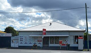
Bororen is a rural town and locality in the Gladstone Region, Queensland, Australia. In the 2016 census, Bororen had a population of 398 people.

Lowmead is a rural town and locality in the Gladstone Region, Queensland, Australia. In the 2021 census, the locality of Lowmead had a population of 179 people.

<span class="mw-page-title-main">Corndale, Queensland</span> Suburb of South Burnett Region, Queensland, Australia

Corndale is a rural locality in the South Burnett Region, Queensland, Australia. In the 2021 census, Corndale had a population of 58 people.

<span class="mw-page-title-main">Glen Eden, Queensland</span> Suburb of Gladstone, Queensland, Australia

Glen Eden is a suburb of Gladstone in the Gladstone Region, Queensland, Australia. In the 2021 census, Glen Eden had a population of 2,918 people.

Iveragh is a rural locality in the Gladstone Region, Queensland, Australia.

<span class="mw-page-title-main">South Trees, Queensland</span> Suburb of Gladstone, Queensland, Australia

South Trees is a coastal industrial suburb of Gladstone in the Gladstone Region, Queensland, Australia. In the 2021 census, South Trees had no population.

The Narrows is a coastal locality in the Gladstone Region, Queensland, Australia. In the 2021 census, The Narrows had a population of 0 people.

Kirkwood is a semi-rural locality in the Gladstone Region, Queensland, Australia. In the 2021 census Kirkwood had a population of 2,513 people.

References

  1. "2021 Clinton (QLD), Census All persons QuickStats | Australian Bureau of Statistics".
  2. 1 2 "Clinton – town in Gladstone Region (entry 40977)". Queensland Place Names. Queensland Government . Retrieved 20 July 2021.
  3. 1 2 "Clinton – suburb in Gladstone Region (entry 49130)". Queensland Place Names. Queensland Government . Retrieved 20 July 2021.
  4. "2021 Clinton (QLD), Census All persons QuickStats | Australian Bureau of Statistics".
  5. "Opening and closing dates of Queensland Schools". Queensland Government . Retrieved 1 July 2014.
  6. "Agency ID 5104, 1 July 2014". Queensland State Archives.
  7. "Clinton, Gladstone". Department of State Development, Infrastructure and Planning. Queensland Government. Archived from the original on 28 July 2014. Retrieved 1 July 2014.
  8. Australian Bureau of Statistics (31 October 2012). "Clinton". 2011 Census QuickStats. Retrieved 1 July 2014. OOjs UI icon edit-ltr-progressive.svg
  9. Australian Bureau of Statistics (27 June 2017). "Clinton (SSC)". 2016 Census QuickStats. Retrieved 20 October 2018. OOjs UI icon edit-ltr-progressive.svg
  10. "2021 Clinton (QLD), Census All persons QuickStats | Australian Bureau of Statistics".
  11. 1 2 "State and non-state school details". Queensland Government. 9 July 2018. Archived from the original on 21 November 2018. Retrieved 21 November 2018.
  12. "Clinton State School". Clinton State School. 28 April 2020. Archived from the original on 23 February 2014. Retrieved 9 December 2021.
  13. "2013 School Annual Report" (PDF). Clinton State School. Clinton State School. Archived from the original (PDF) on 14 July 2014. Retrieved 1 July 2014.
  14. "ACARA School Profile 2018". Australian Curriculum, Assessment and Reporting Authority. Archived from the original on 27 August 2020. Retrieved 28 January 2020.
  15. "Clinton SS - Special Education Program". Archived from the original on 7 August 2020. Retrieved 21 November 2018.
  16. "Airports - Queensland". Queensland Open Data. Queensland Government. 22 October 2020. Archived from the original on 15 November 2020. Retrieved 3 November 2020.
  17. "Land for public recreation - Queensland". Queensland Open Data. Queensland Government. 20 November 2020. Archived from the original on 22 November 2020. Retrieved 22 November 2020.
  18. "Cemeteries". Gladstone Regional Council . Archived from the original on 24 February 2021. Retrieved 18 April 2021.