
The Joseph Chamberlain Memorial Clock Tower, or simply Old Joe, is a clock tower and campanile located in Chancellor's court at the University of Birmingham, in the suburb of Edgbaston. It is the tallest free-standing clock tower in the world, although its actual height is the subject of some confusion. The university lists it as 110 metres (361 ft), 99 metres (325 ft), and 100 metres tall, the last of which is supported by other sources. In a lecture in 1945, Mr C. G. Burton, secretary of the University, stated that "the tower stands 329 ft [100 m] high, the clock dials measure 17 ft [5.2 m] in diameter, the length of the clock hands are 10 and 6 ft [3.0 and 1.8

Clock towers are a specific type of building which house a turret clock and have one or more clock faces on the upper exterior walls. Many clock towers are freestanding structures but they can also adjoin or be located on top of another building. Some other buildings also have clock faces on their exterior but these structures serve other main functions.

The Town Clock is a large clock that stands in downtown Dubuque, Iowa. The clock has stood over the city for over 130 years. The present clock is the second "Town Clock"; the first collapsed in the 1870s, killing three people. The building on which it originally stood is listed on the National Register of Historic Places, but the clock tower itself is not.
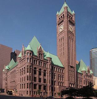
Minneapolis City Hall and Hennepin County Courthouse, designed by Long and Kees in 1888, is the main building used by the city government of Minneapolis, Minnesota as well as by Hennepin County, Minnesota. The structure has served as mainly local government offices since it was built, and today the building is 60 percent occupied by the city and 40 percent occupied by the County. The building is jointly owned by the city and county and managed by the Municipal Building Commission. The Commission consists of the chair of the County Board, the mayor of the City of Minneapolis, a member of the County Board and a member of the Minneapolis City Council. The County Board chair serves as the president of the Commission and the mayor serves as the vice president. The building bears a striking resemblance to the city hall buildings in Cincinnati and Toronto. The City Hall and Courthouse was added to the National Register of Historic Places in 1974.
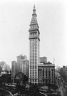
The Metropolitan Life Insurance Company Tower, is a skyscraper occupying a full block in the Flatiron District of Manhattan in New York City. The building is composed of two sections: a 700-foot-tall (210 m) tower at the northwest corner of the block, at Madison Avenue and 24th Street, and a shorter east wing occupying the remainder of the block bounded by Madison Avenue, Park Avenue South, 23rd Street, and 24th Street. The South Building, along with the North Building directly across 24th Street, comprises the Metropolitan Home Office Complex, which originally served as the headquarters of the Metropolitan Life Insurance Company.

Jaffa Gate is one of the seven main open Gates of the Old City of Jerusalem.

The Cana Island lighthouse is a lighthouse located just north of Baileys Harbor in Door County, Wisconsin, United States.
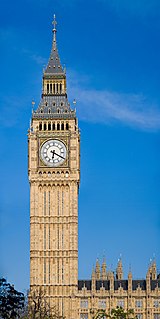
Big Ben is the nickname for the Great Bell of the striking clock at the north end of the Palace of Westminster; the name is frequently extended to refer to both the clock and the clock tower. The official name of the tower in which Big Ben is located was originally the Clock Tower; it was renamed Elizabeth Tower in 2012 to mark the Diamond Jubilee of Elizabeth II, Queen of the United Kingdom.

The Beloit water tower is a historic octagonal limestone water tower completed in 1889 in Beloit, Wisconsin.

Eden Park Standpipe is an ornate historic standpipe standing on the high ground of Eden Park in Cincinnati, Ohio. The standpipe is a form of water tower common the late 19th century. It was listed in the National Register on March 3, 1980.

The Lena Water Tower is a water tower located in the village of Lena, Illinois, United States. It was built in 1896 following two decades of problems with structure fires in the village. The current water tower is the result of a second attempt after the first structure proved to be unstable. The tower stands 122.5 feet (37.3 m) tall and is built of limestone and red brick. The current stainless steel water tank holds 50,000 gallons and replaced the original wooden tank in 1984. The site has two other structures, an old power plant building and a 100,000 US gallon reservoir. The Lena Electric Plant Building was constructed in 1905 and the reservoir completed in 1907. The Lena Water Tower was listed on the U.S. National Register of Historic Places in 1997; the reservoir was included as a contributing property to the listing.
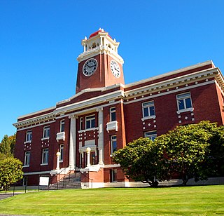
The Clallam County Courthouse is located at 319 Lincoln Street in Port Angeles, Washington. It was built in 1914–15, replacing an older wood courthouse built in 1892, and officially dedicated on June 14, 1915. A 1979 expansion, connected to the historic courthouse by an enclosed bridge, now houses many of the official functions, including courts, public records, and a jail. The historic courthouse now houses the Clallam County Museum and the county Parks, Fair and Facilities Department.
The Forbes Hill Standpipe is a historic water tower structure located on Reservoir Road in Quincy, Massachusetts, USA. The tower was built in 1899-1902 to contain a 330,000 US gallons steel water tank. The site originally included an adjacent reservoir that supplied the Quincy with water from the Metropolitan Boston Water System. The standpipe was taken out of service in 1955 and the reservoir was filled in.

The Hancock County Courthouse is a historic courthouse in Findlay, Ohio, United States. Built between 1886 and 1888, it was listed on the National Register of Historic Places in 1973.

The Benson Water Tower was a water tower located on Clayton Street in Benson, Illinois. The tower was built in 1891, in response to several serious fires in Benson; it supplied the village with water until 1985. The tall brick tower had a large wooden water tank on top. The tower was added to the National Register of Historic Places in 1987. It has since been demolished, and was delisted in 2020.

Mackay Estate Water Tower is a historic water tower located at East Hills in Nassau County, New York. The tower is a utilitarian structure manufactured by the Phillipsburg, New Jersey firm of Tippett and Wood. The tank is round in plan and topped by a bell-shaped slate roof and copper cupola. The tank stands on eight legs, each of which is 34 feet tall. The water tower and tank are concealed inside a tall structure designed by Stanford White that is constructed of stone, laid in random ashlar, and the roof is spanned by a Guastavino tile dome. The tower was originally a component of Clarence Mackay's Harbor Hill Estate.

The Grand Avenue Water Tower is a water tower located at the intersection of Grand Avenue and 20th street in the College Hill neighborhood of St. Louis, Missouri. It is the oldest extant water tower in St. Louis, pre-dating both the Bissell Street Water Tower and the Compton Hill Water Tower.

The Clarion County Courthouse and Jail is a historic courthouse and jail located in Clarion, Clarion County, Pennsylvania. The courthouse was built between 1883 and 1885, and is a 3 1/2-story, brick Victorian structure with Classical details measuring 78 feet, 8 inches, wide and 134 feet deep. It has a 213 foot tall, 25 feet square, clock tower. The jail was built between 1873 and 1875, and is a half brick / half sandstone building, located behind the courthouse.

The City of Beloit Waterworks and Pump Station was built in 1885 in Beloit, Wisconsin just below a hill on top of which sits the Beloit Water Tower. It was added to the National Register of Historic Places in 1990.

Mahimangad Fort, in Man lies within the village limits of Mahimangad villege about five and a half miles west of Dahivadi. The easiest way to it is by the Satara-Pandharpur road to a point about half a mile west of the pass descending into the lower parts of the Man taluka. From this point a broad track branches off northwards to the fort which lies not more than half a mile from the road. There are three hamlets close on the north of the fort which towers about 250 feet above them. It consists of a flat nearly triangular table land with the apex to the east surmounting a perpendicular scarp of black trap below which are steep slopes of short grass with a little soil. The sides are overgrown in places with prickly pear especially on the north-west corner. The ascent should be made from the second hamlet which will be encountered on approaching the Pandharpur road from the north-west. A path about five feet wide with rude steps at intervals of almost every yard takes to the fort. A steep walk of about five minutes leads up to the gateway, the immediate approach to which is in places almost blocked by prickly pear. The path which leads up the side in a south-east direction here takes a turn at nearly right angles to the south-west. But before entering, the visitor will probably go some fifteen yards further to see a small tank cut in the rock, the site of an excellent spring always full of water and furnishing the neighbouring hamlets with their hot weather supply. The gateway has been cut in the scarp about thirty feet below the summit. The passage cut is about six feet wide but the gateway narrows to about five feet. It consisted as usual of a single pointed arch about seven feet high of well cut masonry the top of which has fallen in. Inside are twenty-two rock-cut steps which wind through a right angle and lead to the top facing east. The inner side of the curve is as usual protected and the way up the steps proportionately narrowed by a curtain of solid masonry. On emerging on the top and proceeding east along the north face of the fort on right hand is a small hillock on which stood the office now in ruins. A little further on is a water tank thirty feet square, originally built of well cut masonry, but now a great deal fallen in. Near it are two small tanks lined with cement for the storage either of grain or water, and to the south of these is a large pit roughly hewn out of the rock, perhaps intended for prisoners as in Varugad. About fifty yards further east is a turret of considerable size the masonry of which is solid and on which a gun was planted. This turret stretches right across the fort but underneath it on the southern side is an archway about four feet high by two broad. But creeping through it is reached the eastern end which tapers off nearly to a point. The fort is about a hundred yards long by forty wide. The walls are about five or six feet high and the masonry, except the top layer, is in fair preservation. At the east end is one, and at the west end are two bastions at the north-west and south-west angles. Originally all three were crowned with guns and there are still remains of parapets on them. On the east bastion is a small stone placed erect for a ling and worshipped as the image of the god Jajarnath Mahadev. A small fair is held in honour of the god and the existence of this shrine explains how the path up to the fort is in good order. There is also a ruined building of loose stones near the south-west bastion in honour of some Muhammedan saint or pir.


