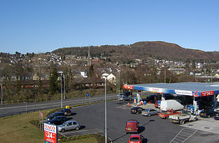
Pontardawe is a town and a community in the Swansea Valley in Wales. With a population of 6,832, it comprises the electoral wards of Pontardawe and Trebanos. A town council is elected. Pontardawe forms part of the county borough of Neath Port Talbot. On the opposite bank of the River Tawe, the village of Alltwen, part of the community of Cilybebyll, is administered separately from Pontardawe, but has close ties to the town. Pontardawe is at the crossroads of the A474 road and the A4067 road. Pontardawe came into existence as a small settlement on the northwestern bank of the Tawe where the drovers' road from Neath and Llandeilo crossed the river to go up the valley to Brecon.

The River Tawe is a 30 miles (48 km) long river in South Wales. Its headwaters flow initially east from its source below Llyn y Fan Fawr south of Moel Feity in the Black Mountains, the westernmost range of the Brecon Beacons National Park, before the river turns south and then southwest to its estuary at Swansea. Its main tributaries are the right bank Upper and Lower Clydach Rivers and the Afon Twrch. The total area of the catchment is some 246 km2 (95 sq mi). The Tawe passes through a number of towns and villages including Ystradgynlais, Ystalyfera, Pontardawe, and Clydach and meets the sea at Swansea Bay below Swansea. The Tawe Valley is more commonly known as the Swansea Valley.

The Swansea Vale Railway (SVR) was a railway line connecting the port of Swansea in South Wales to industries and coalfields along the River Tawe on the northern margin of Swansea, by taking over a tramroad in 1846. It was extended to Brynamman in 1868. Passengers were carried from 1860, and a loop line through Morriston was built.
Morriston is a community in the City and County of Swansea, Wales and falls within the Morriston ward. It is the largest community in Swansea county.

Clydach is both a village and a community in Swansea, Wales, within the Clydach ward and the Llangyfelach parish. It is located 6 miles (9.7 km) northeast of Swansea city centre. In 2011, the population was 7,503. Welsh is the first language of 24 per cent of the population and both Welsh and English language schools are available. The village lies close to the M4 motorway which can be accessed via the bypass or old road via Ynystawe. The community includes part of the village of Glais.

Llansamlet railway station is a minor station in Llansamlet, Swansea, south Wales. The station is located below street level at Frederick Place in Peniel Green, 212 miles 8 chains (341 km) from London Paddington. It is served by local trains operated by Transport for Wales on the South Wales Main Line between Swansea and Cardiff.

The Swansea Canal was a canal constructed by the Swansea Canal Navigation Company between 1794 and 1798, running for 16.5 miles (26.6 km) from Swansea to Hen Neuadd, Abercraf in South Wales. It was steeply graded, and 36 locks were needed to enable it to rise 373 feet (114 m) over its length. The main cargos were coal, iron and steel, and the enterprise was profitable.
Alltwen is a village in the Swansea Valley in Wales. Alltwen forms part of the community of Cilybebyll and is administered separately from adjoining Pontardawe on the opposite bank of the River Tawe.
The Swansea Valley is one of the South Wales Valleys. It is the valley from the Brecon Beacons National Park to the sea at Swansea of the River Tawe in Wales. Administration of the area is divided between the City and County of Swansea, Neath Port Talbot County Borough, and Powys. A distinction may be drawn between the Lower Swansea valley and the Upper Swansea valley; the former was more heavily industrialised during the 19th and 20th centuries.
Swansea Docks is the collective name for several docks in Swansea, Wales. The Swansea docks are located immediately south-east of Swansea city centre. In the mid-19th century, the port was exporting 60% of the world's copper from factories situated in the Tawe Valley. The working docks area today is owned and operated by Associated British Ports as the Port of Swansea and the northern part around the Prince of Wales Dock is undergoing re-development into a new urban area branded the SA1 Swansea Waterfront.
The Lower Swansea valley is the lower half of the valley of the River Tawe in south Wales. It runs from approximately the level of Clydach down to Swansea docks, where it opens into Swansea Bay and the Bristol Channel. This relatively small area was a focus of industrial innovation and invention during the Industrial Revolution, leading to a transformation of the landscape and a rapid rise in the population and economy of Swansea.
The Rhondda and Swansea Bay Railway was a Welsh railway company formed to connect the upper end of the Rhondda Fawr with Swansea, with the chief objective of transporting coal and other minerals to Swansea docks. It was incorporated in 1882, but at first the connection to Swansea from Briton Ferry was refused.

Penwyllt is a hamlet located in the upper Swansea Valley in Powys, Wales, lying within the Brecon Beacons National Park.

Pontardawe railway station was a railway station on the Swansea Vale Railway that ran along the River Tawe. British Railways closed the station to passengers in 1950. The line continued carrying coal but with the decline in coal mining the station closed completely in 1965.
Hafod is a district of the city of Swansea, in South Wales, U.K., and lies just north of the city centre, within the Landore ward. Hafod is the home to the Hafod Copperworks, founded in 1810 and closed in 1980 which is now being developed into an industrial heritage site.

Coelbren is a small rural village within the community of Tawe Uchaf in southernmost Powys, Wales. It lies on the very northern edge of the South Wales Coalfield some six miles north-east of Ystradgynlais and just outside the southern boundary of the Brecon Beacons National Park. It is known for Henrhyd Falls, a 27m high waterfall which serves as a National Trust-managed visitor attraction on the Nant Llech. To the east of the village flows the Afon Pyrddin which plunges over two more spectacular falls.
Colbren Junction was a railway station on the Neath and Brecon Railway. The station, which was near Coelbren, was completed at the same time as the Swansea Vale and Neath and Brecon Joint Railway opened a seven-mile branch from here to Ynysygeinon in 1873. It was a key junction in the networks operated by the Midland, Neath and Brecon, and Great Western railway companies.

Cwmavon Glam railway station served the village of Cwmafan, in the historical county of Glamorganshire, Wales, from 1885 to 1964 on the Rhondda and Swansea Bay Railway.
Glais railway station served the community of Glais in Swansea, Wales from 1885 to 1965 on the Swansea Vale Railway.
