
The Cotswolds is an area in south-central England, along a range of rolling hills that rise from the meadows of the upper Thames to an escarpment above the Severn Valley and Evesham Vale.
Dursley is a market town and civil parish in southern Gloucestershire, England, situated almost equidistantly between the cities of Bristol and Gloucester. It is under the northeast flank of Stinchcombe Hill, and about 3+3⁄4 miles (6.0 km) southeast of the River Severn. The town is adjacent to Cam which, though a village, is a slightly larger community in its own right.

Stroud is a market town and civil parish in the centre of Gloucestershire, England. It is the main town in Stroud District.

Woodchester is a Gloucestershire village in the Nailsworth Valley, a valley in the South Cotswolds in England, running southwards from Stroud along the A46 road to Nailsworth. The parish population taken at the 2011 census was 1,206.

The Cotswold Water Park is the United Kingdom's largest marl lake system, straddling the Wiltshire–Gloucestershire border, northwest of Cricklade and south of Cirencester. There are 180 lakes, spread over 42 square miles (110 km2).
Uley is a village and civil parish in the county of Gloucestershire, England. The parish includes the hamlets of Elcombe and Shadwell and Bencombe, all to the south of the village of Uley, and the hamlet of Crawley to the north. The village is situated in a wooded valley in the Cotswold escarpment, on the B4066 road between Dursley and Stroud.

The Five Valleys are a group of valleys in Gloucestershire, England, which converge on the town of Stroud at the western edge of the Cotswolds. The Five Valleys are notable both for the landscape, which attracts visitors, and their role in industrial development of Britain starting with the wool trade in the 11th Century, and developing through cloth manufacturing in the 18th Century. Despite very poor roads, the use of the rivers and streams in developing links to other centres, via, for example the Kennet and Avon Canal, helped the Five Valleys to prosper.

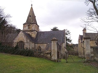
Coaley is a village in the English county of Gloucestershire roughly 4 miles from the town of Dursley, and 5 miles from the town of Stroud. The village drops from the edge of the Cotswold Hills, overlooked by Frocester Hill and Coaley Peak picnic site, towards the River Cam at Cam and Cambridge and the Severn Estuary beyond. It has a population of around 770.
Dowdeswell is a civil parish in the ward of Chedworth, Cotswold, in the ceremonial county of Gloucestershire, England. It is separated into Upper and Lower Dowdeswell, the former being south of the latter. The population of the civil parish at the 2011 census was 134.

Uley Bury is the long, flat-topped hill just outside Uley, Gloucestershire, England. It is an impressive multi-vallate, scarp-edge Iron Age hill fort dating from around 300 B.C. Standing some 750 feet above sea level it has views over the Severn Vale.

Rodborough is a civil parish in the district of Stroud, Gloucestershire, in South West England. It is directly south of the parish of Stroud, north of the town of Nailsworth and north-west of the village of Minchinhampton. The parish includes the settlements of Bagpath, Butterrow, Kingscourt, Lightpill and Rooksmoor, and is adjacent to the Stroud suburb of Dudbridge. The population taken at the 2011 census was 5,334.

Nympsfield is a village and civil parish in the English county of Gloucestershire. It is located around four miles south-west of the town of Stroud. As well as Nympsfield village, the parish contains the hamlet of Cockadilly. The population taken at the 2011 census was 382.

Dowdeswell Reservoir and former water treatment works lie below the parish of Dowdeswell in Gloucestershire. They were originally built by Cheltenham Corporation to supply the town of Cheltenham with drinking water and subsequently became part of the Severn Trent network.

Dursley railway station served the town of Dursley in Gloucestershire, England, and was the terminus of the short Dursley and Midland Junction Railway line which linked the town to the Midland Railway's Bristol to Gloucester line at Coaley Junction.
Cam railway station served the village of Cam in Gloucestershire, England. The station was on the short Dursley and Midland Junction Railway line which linked the town of Dursley to the Midland Railway's Bristol to Gloucester line at Coaley Junction.
The Cotswold Canals Trust is a British registered charity that aims to protect and restore the Stroudwater Navigation and the Thames and Severn Canal. Formed in 1972, the organisation has a goal to restore navigability on the two waterways between Saul Junction to the River Thames. Since then, it has overseen restoration of the waterways, with many bridges, locks, and cuttings being rebuilt and reinstated.
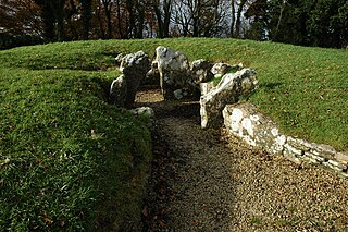
Nympsfield Long Barrow is the remains of a Neolithic burial site or barrow, located close to the village of Nympsfield in Gloucestershire, South West England.

Wotton Hill is a hill on the edge of the Cotswold Hills in Gloucestershire, England, 0.5 miles (0.80 km) north of Wotton-under-Edge. The Cotswold Way passes over the hill.

Coaley Wood Quarries is a 4.85-hectare (12.0-acre) geological Site of Special Scientific Interest in Gloucestershire, notified in 1974.
