Coari

Last updated
Coari
Igreja Matriz de Coari, Amazonas.jpeg
Coari bandeira.jpg
Brasao de Coari.jpg
Nickname: 
"Solimões Queen" "Gas City"
Amazonas Municip Coari.svg
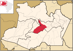
Coari municipality (red) in Amazonas state
Coordinates: 04°05′06″S63°08′27″W / 4.08500°S 63.14083°W / -4.08500; -63.14083
Country Flag of Brazil.svg  Brazil
Region North
State Bandeira do Amazonas.svg Amazonas
Government
   Mayor Manoel Adail Amaral Pinheiro (PRP)
Area
   Municipality 57,921.646 km2 (22,363.673 sq mi)
Elevation
40 m (120 ft)
Population
 (2020 [1] )
   Metro
85,910
Time zone UTC−4 (AMT)
ZIP code
69460-000
Climate Af
Website www.coari.am.gov.br

Coari (Choary) is a municipality located in the Brazilian state of Amazonas.

Contents

Geography

The municipal seat of Coari is one of the largest cities of the Amazonas state. It is the seat of the Roman Catholic Diocese of Coari. The area has reserves of oil and natural gas. Coari is served by Coari Airport located 6 km from downtown Coari. Porto Urucu Airport located in the district of Porto Urucu 470 km away serves the population residing and working for Petrobras.

The municipality is in the Juruá-Purus moist forests ecoregion. [2] It contains part of the Amanã Sustainable Development Reserve. [3] It contains a small portion of the 1,008,167 hectares (2,491,230 acres) Piagaçu-Purus Sustainable Development Reserve, established in 2003. [4] The municipality contains 66.15% of the 217,486 hectares (537,420 acres) Catuá-Ipixuna Extractive Reserve, established in 2003 as the first extractive reserve in the state of Amazonas. [5]

Climate

Climate data for Coari (1981–2010, extremes 1961–present)
MonthJanFebMarAprMayJunJulAugSepOctNovDecYear
Record high °C (°F)36.9
(98.4)
36.6
(97.9)
36.4
(97.5)
36.4
(97.5)
36.0
(96.8)
38.0
(100.4)
39.8
(103.6)
37.5
(99.5)
38.3
(100.9)
38.2
(100.8)
38.3
(100.9)
38.2
(100.8)
39.8
(103.6)
Mean daily maximum °C (°F)31.8
(89.2)
31.9
(89.4)
32.0
(89.6)
31.9
(89.4)
31.7
(89.1)
31.7
(89.1)
32.2
(90.0)
33.2
(91.8)
33.3
(91.9)
33.2
(91.8)
32.6
(90.7)
32.1
(89.8)
32.3
(90.1)
Daily mean °C (°F)26.4
(79.5)
26.4
(79.5)
26.6
(79.9)
26.6
(79.9)
26.6
(79.9)
26.4
(79.5)
26.8
(80.2)
27.4
(81.3)
27.4
(81.3)
27.3
(81.1)
27.0
(80.6)
26.8
(80.2)
26.8
(80.2)
Mean daily minimum °C (°F)21.6
(70.9)
21.8
(71.2)
22.0
(71.6)
22.0
(71.6)
22.1
(71.8)
21.9
(71.4)
21.9
(71.4)
22.2
(72.0)
22.3
(72.1)
22.4
(72.3)
22.4
(72.3)
22.2
(72.0)
22.1
(71.8)
Record low °C (°F)14.6
(58.3)
15.4
(59.7)
10.6
(51.1)
15.6
(60.1)
14.0
(57.2)
10.2
(50.4)
11.0
(51.8)
14.8
(58.6)
15.0
(59.0)
15.7
(60.3)
16.4
(61.5)
15.2
(59.4)
10.2
(50.4)
Average precipitation mm (inches)264.5
(10.41)
265.5
(10.45)
322.3
(12.69)
272.4
(10.72)
213.1
(8.39)
128.9
(5.07)
87.2
(3.43)
68.9
(2.71)
100.4
(3.95)
156.7
(6.17)
215.6
(8.49)
261.7
(10.30)
2,357.2
(92.80)
Average precipitation days (≥ 1.0 mm)181718171613989121316166
Average relative humidity (%)85.684.984.985.085.183.980.878.178.879.781.983.682.7
Mean monthly sunshine hours 138.2120.2122.0132.5152.5171.2207.1208.8180.4171.7141.1143.11,888.8
Source 1: Instituto Nacional de Meteorologia [6]
Source 2: Meteo Climat (record highs and lows) [7]

Related Research Articles

<span class="mw-page-title-main">Purus River</span> River in Brazil, Peru

The Purus River is a tributary of the Amazon River in South America. Its drainage basin is 371,042 km2 (143,260 sq mi), and the mean annual discharge is 11,207 m3/s (395,800 cu ft/s). The river shares its name with the Alto Purús National Park and the Purús Province, one of the four provinces of Peru in the Ucayali Region.

<span class="mw-page-title-main">Tefé</span> Municipality in North, Brazil

Tefé, known in early accounts as Teffé, is a municipality in the state of Amazonas, northern Brazil.

<span class="mw-page-title-main">Lábrea</span> Municipality in North, Brazil

Lábrea is the southernmost municipality in the Brazilian state of Amazonas.

<span class="mw-page-title-main">Anori</span> Municipality in North, Brazil

Anori is a municipality located in the Brazilian state of Amazonas. Its population was 21,477 (2020) and its area is 5,795 km².

<span class="mw-page-title-main">Apuí</span> Municipality in North, Brazil

Apuí is a municipality located in the Brazilian state of Amazonas. Its population was 22,359 (2020) and its area is 54,240 km2.

<span class="mw-page-title-main">Barcelos, Amazonas</span> Municipality in North, Brazil

Barcelos, formerly Mariuá, is a municipality located in the State of Amazonas, northern Brazil. Its population was 27,638 (2020) and its area is 122,476 square kilometres (47,288 sq mi), making it the second largest municipality in Brazil, equivalent in size to New York state in the United States and slightly larger than North Korea.

<span class="mw-page-title-main">Beruri</span> Municipality in North, Brazil

Beruri is a municipality located in the Brazilian state of Amazonas. Its population was 20,093 (2020) and its area is 17,251 km².

<span class="mw-page-title-main">Borba, Amazonas</span> Municipality in North, Brazil

Borba is a municipality in the state of Amazonas in northern Brazil.

<span class="mw-page-title-main">Canutama</span> Municipality in North, Brazil

Canutama is a municipality located in the Brazilian state of Amazonas, considered third largest city of the Purus Medium after Lábrea and Tapauá.

<span class="mw-page-title-main">Carauari</span> Municipality in North, Brazil

Carauari is a municipality located in the Brazilian state of Amazonas. Its population was 28,508 (2020) and its area is 25,767 km².

<span class="mw-page-title-main">Jutaí</span> Municipality in North, Brazil

Jutaí is a municipality located in the Brazilian state of Amazonas. Its population is 13,886 (2020) and its area is 69,552 km², making it the fifth largest municipality in Amazonas by area and the ninth largest in Brazil.

<span class="mw-page-title-main">Novo Aripuanã</span> Municipality in North, Brazil

Novo Aripuanã is a municipality located in the Brazilian state of Amazonas.

<span class="mw-page-title-main">Pauini</span> Municipality in North, Brazil

Pauini is a municipality located in the Brazilian state of Amazonas.

<span class="mw-page-title-main">Tapauá</span> Municipality in North, Brazil

Tapauá is a municipality located in the Brazilian state of Amazonas. Its population was 17,015 (2020) and its area is 89,324 km2, making it the third largest municipality in Amazonas and the fifth largest in Brazil, comparable to South Carolina or Jordan.

Abufari Biological Reserve is a biological reserve in the state of Amazonas, Brazil. It is mostly lowland tropical rainforest, with very diverse flora and fauna.

The Jari River is a river in the state of Amazonas, Brazil, a tributary of the Purus River.

Piagaçu-Purus Sustainable Development Reserve is a sustainable development reserve in the state of Amazonas, Brazil.

<span class="mw-page-title-main">Catuá-Ipixuna Extractive Reserve</span>

The Catuá-Ipixuna Extractive Reserve is an extractive reserve in the state of Amazonas, Brazil. It takes its name from two lakes that drain into the Solimões River, or Upper Amazon, and is covered in Amazon rainforest.

The Igapó-Açu Sustainable Development Reserve is a sustainable development reserve in the state of Amazonas, Brazil. It is part of a "green barrier" created to prevent deforestation along the BR-319 highway.

The Tapauá State Forest is a state forest in the state of Amazonas, Brazil.

References

  1. IBGE 2020
  2. Sears, Robin, South America: Amazon Basin, northwestern Brazil (NT0133), WWF: World Wildlife Fund, retrieved 2017-03-28
  3. RDS Amanã (in Portuguese), ISA: Instituto Socioambiental, retrieved 2016-05-05
  4. RDS Piagaçu-Purus (in Portuguese), ISA: Instituto Socioambiental, retrieved 2016-08-20
  5. RESEX Catuá-Ipixuna (in Portuguese), ISA: Instituto Socioambiental, retrieved 2016-08-30
  6. "Normais Climatológicas Do Brasil 1981–2010" (in Portuguese). Instituto Nacional de Meteorologia. Retrieved 26 October 2018.
  7. "Station Coari" (in French). Meteo Climat. Retrieved 26 October 2018.

IBGE