Cobden, Ontario

Last updated

Cobden
Cobden mosbo6.jpg
Main Street in Cobden
Renfrew locator map 2021.svg
Red pog.svg
Cobden
Canada Southern Ontario location map 2.png
Red pog.svg
Cobden
Coordinates: 45°37′37″N76°52′53″W / 45.62694°N 76.88139°W / 45.62694; -76.88139
Country Flag of Canada (Pantone).svg  Canada
Province Flag of Ontario.svg  Ontario
County Renfrew
Post office1850
Incorporated village1900
Area
  Total1.85 km2 (0.71 sq mi)
Elevation
145 m (476 ft)
Population
 (2021) [1] [2]
  Total1,071
Time zone UTC−05:00 (EST)
  Summer (DST) UTC−04:00 (EDT)
Postal Code FSA
K0J
Area codes 613

Cobden is a small community in the Township of Whitewater Region, in Renfrew County, Ontario, Canada. It is located 95 kilometres (59 mi) northwest of Ottawa, [3] and roughly halfway between Renfrew and Pembroke on Highway 17.

Contents

History

The area around Cobden was originally inhabited by the Nibachis, a sub-division of the native, Algonquian speaking, tribes of North America.

Champlain's astrolabe

In 1613, French explorer Samuel de Champlain, travelled through an area very near Cobden while exploring the Ottawa River. Due to the Chenaux Rapids, Champlain and his men were forced to portage. They presumably took shore in Browns Bay near present-day McKenzie's Hill. In 1953, a large rock was found in this area bearing a chiseled inscription. Though the inscription was hard to read, it was determined that it said, "Champlain Juin 2, 1613". Champlain's trail from this point is debatable. He may have cut straight across land to the southern tip of Jeffreys Lake, or he may have veered south, skirting the far side of what later came to be known as the Champlain Trail Lakes. It is known that he eventually made his way to Green Lake and at this point, according to several 19th-century authors, Champlain lost his astrolabe. It stayed there for 254 years, until it was found in 1867 by Edward George Lee, a 14-year-old farm boy helping his father clear trees near Green Lake (now Astrolabe Lake). Edward gave the astrolabe to Captain Cowley, a Steamboat Captain on Muskrat Lake; Lee never received the ten dollars Cowley promised him, and Cowley sold the astrolabe to his employer, President of the Ottawa Forwarding Company, R.W. Cassels. The astrolabe eventually passed to Samuel V. Hoffman of the New York Historical Society in 1942, remaining there for 47 years, until acquired by the Department of Communications for the Canadian Museum of Civilization in 1989.

In 1990, a special celebration was held in Cobden in honour of the astrolabe's return.

Although it cannot be conclusively proven that the astrolabe found near this Lake indeed belonged to Champlain, the following facts should be taken into consideration:

Founding and development

Early years

Cobden's very existence is a circumstance of location. As Pembroke and Ottawa grew so, it seemed, did the gap between them. In the 1800s the easiest route between the two was the Ottawa River. However, the presence of rapids near Portage du Fort necessitated a land route. At this time the area was mostly a vast forest untouched by Europeans. A few settlers had put down near muskrat lake, (John Parsons, John Sheriff, Spencer Allen, Robert Allen, and others) but for the most part there had been little activity since Champlain's visit in the 17th century. Then in 1849 Jason Gould built a road from what came to be called Goulds Landing to what would become Cobden on Muskrat lake. One could catch a steamer down the lake and then go on by road to Pembroke. The traffic on the road couldn't help but cause growth. In 1850 Gould built a Post Office and named the fledgling settlement Cobden after Richard Cobden, member of British Parliament, whom Gould admired. By October 2, 1876, the railway had crept its way to Cobden. The community started to expand from the lake towards the railway station further inland. Main Street began to take shape, The Cobden Sun , The Bank of Ottawa, black smith shops, a bakery, general store, mill, surgeon and jewelry store. In 1880 A public school was opened to accommodate the strain on nearby S.S.No 1. Cobden was soon the biggest community in Ross Township and became an Incorporated Village in October 1901.

1901-present

Cobden has been the victim of many fires. This has destroyed almost all of the original buildings. Main Street has suffered worst from fire including one in 1913 which destroyed the Cobden Sun building and many historical records. A hydro electric dam began operating at the falls south of Cobden. It supplied the town, off and on, with power until it was destroyed, April 12, 1934, in a raging flood. Large blocks of ice ripped the dam apart and poured over Highway 17, tearing away sections of pavement. The plant operator, Mr. Bill Wall, was stranded in the upper section of their house until flooding subsided. The town then started receiving power from a station in Calabogie. Council elections in 1949 were dominated by the issue of whether or not to hold another plebiscite on establishing a waterworks system. A previous plebiscite had come out 82–56 against. But times were changing quickly; after the war a new council was elected and the next vote was 124–46 in favour and by the early 1950s Cobden had water. The waterworks system required constant maintenance up until a major retooling in the 1980s. The visibly dominating water tower was built in 1988 replacing the original (built in 1951).

A bigger school was needed by 1903. The present-day school, Cobden District Public, was built in 1938 and initially served as a high school until Opeongo High School was built.

In 2001, the Village of Cobden was amalgamated with the Village of Beachburg, the Township of Ross and the Township of Westmeath to form the Township of Whitewater Region.

Today, Cobden's location on the busy Trans-Canada Highway, known as Highway 17, makes it a convenient stopping place for the many travelers passing through the area.

Demographics and culture

In 1991 Cobden had a population of 1026. In 1996 Cobden had a population of 1,020. The population of the town decreased by 0.58%.

Occupying 1.85 km of land, Cobden has a population density of 551.351 people per square km.[ citation needed ]

Cobden is host to its own annual fair and is held in late August each year. Established in 1854, The Cobden Fair offers several days of activities that include exhibits, cattle, horse and sheep shows, midway rides and a demolition derby. During the holiday season, it has its own Santa Claus Parade. From May until October, located at the Cobden fairgrounds, and offering fresh local grown produce, homemade baking and a wide assortment of crafts is one of the best farmers' markets in the Ottawa Valley.[ citation needed ]

The Farmers' Market

Organized in 1991. The Farmers' Market is an outdoor market that runs from May to October. It offers a wide variety of crafts and foodstuffs and everything must be grown or handmade locally. The market has recently moved from the Memorial Hall grounds to the Fair Grounds but the Christmas Market, the grande finale for the year, is still held in the Memorial Hall

Cobden Park

Overlooking Muskrat Lake the park occupies what is thought to be the spot where Champlain met the Native Chief Nibachis. A plaque was erected in the 1960s commemorating this. The lands for the park were donated by Thomas Robinson and his wife in 1904. In 1988 extensive work was carried out on the beach portion of the park by the Civitans.

Bruce McPhail Memorial Airport

Home to The Champlain Flying Club, the Cobden airport is just south of the village on Highway 17.

Logos Land

Located about 5 miles east of Cobden, Logos Land is a religious based water park. Built on the site of the Astrolabe's discovery, Logos Land features five water slides, paddle boats, mini-golf and a representation of Noah's Ark. The water park is open mid-June to Labour Day, but Noah's Ark is open year-round. It's also home to Canada's tallest Christmas tree, standing 22 meters high. Every year over 3000 local children decorate the tree, which is dedicated to children around the world.

Mussie

Mussie is a Nessie-like creature said to reside in Muskrat Lake. It most likely doesn't exist, and if it does, is more likely a sturgeon. A handmade wooden tribute to Mussie can be found in front of the local Home Hardware Store. It stands 3 meters high and approximately 12 feet long, built by the previous store owner.

Ottawa Valley Pentecostal Camp

Ottawa Valley Pentecostal Camp is a Christian based family and children's camp at the bottom of Muskrat Lake. It has hosted many local community events with its year round facilities. Members of surrounding churches in the Ottawa area rent out trailers and stay at camp during the summer. OVPC is owned and operated by the Pentecostal Assemblies of Canada.

Notable people

Cobden as seen from the south-east Cobdenpic.jpg
Cobden as seen from the south-east

Related Research Articles

<span class="mw-page-title-main">Algonquin people</span> Indigenous people of Eastern Canada

The Algonquin people are an Indigenous people who now live in Eastern Canada. They speak the Algonquin language, which is part of the Algonquian language family. Culturally and linguistically, they are closely related to the Odawa, Potawatomi, Ojibwe, Mississaugas, and Nipissing, with whom they form the larger Anicinàpe (Anishinaabeg). Algonquins call themselves Omàmiwinini or the more generalised name of Anicinàpe.

<span class="mw-page-title-main">Arnprior</span> Town in Ontario, Canada

Arnprior is a town in Renfrew County, in the eastern portion of Southern Ontario, Canada. It is located 65 km (40 mi) west of Downtown Ottawa, at the confluence of the Madawaska River and the Ottawa River in the Ottawa Valley. Arnprior has experienced significant growth in populations with the widening of the 417 Provincial Highway to four lanes. The town experienced an increase in population by 8.4% from 2011 to 2016, at which time its population was 8,795. The town is a namesake of Arnprior, Scotland, and is known for lumber, hydro power generation, aerospace, farming and its proximity to the National Capital Region.

<span class="mw-page-title-main">Ottawa Valley</span> Valley in Ontario and Quebec in Canada

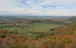
The Ottawa Valley is the valley of the Ottawa River, along the boundary between Eastern Ontario and the Outaouais, Quebec, Canada. The valley is the transition between the Saint Lawrence Lowlands and the Canadian Shield. Because of the surrounding shield, the valley is narrow at its western end and then becomes increasingly wide as it progresses eastward. The underlying geophysical structure is the Ottawa-Bonnechere Graben. Approximately 1.3 million people reside in the valley, around 80% of whom reside in Ottawa. The total area of the Ottawa Valley is 2.4 million ha. The National Capital Region area has just over 1.4 million inhabitants in both provinces.

<span class="mw-page-title-main">Drummond/North Elmsley</span> Township in Ontario, Canada

Drummond/North Elmsley is a township in eastern Ontario, Canada in Lanark County. It is situated on the north shore of the Rideau River between the town of Perth and the town of Smiths Falls. It is a predominantly rural municipality. The township offices are located in the hamlet of Port Elmsley.

<span class="mw-page-title-main">Whitewater Region</span> Township in Ontario, Canada

Whitewater Region is a township on the Ottawa River in Renfrew County, located within the scenic Ottawa Valley in eastern Ontario, Canada. Whitewater Region is made up of the former municipalities of Beachburg, Cobden, Ross and Westmeath, which were amalgamated into the current township on January 1, 2001.

<span class="mw-page-title-main">Muskrat River (Ontario)</span> River in Ontario, Canada

The Muskrat River is a river in Renfrew County, Ontario, Canada that flows into the Ottawa River at the city of Pembroke.

<span class="mw-page-title-main">Nipissing, Ontario</span> Township in Ontario, Canada

Nipissing is an incorporated (political) township in Parry Sound District in Central Ontario, Canada. It is on Lake Nipissing and is part of the Almaguin Highlands region. Nipissing was surveyed between 1874 and 1881, and was incorporated in 1888. Among the first settlers in the area were the Chapman and Beatty families. Nipissing Township annexed Gurd Township in 1970. The township also contains a community named Nipissing, which is located on the South River near Chapman's Landing, on the South Bay of Lake Nipissing. The township administrative offices are located in Nipissing.

<span class="mw-page-title-main">Storyland (Ontario)</span>

Storyland was a children’s theme park located northwest of Ottawa, Ontario, Canada, near the town of Renfrew in Horton Township featuring depictions of classic fairy tale scenes. The park featured a mini-golf course, a small water park, live performers, playgrounds, small rides, and staff dressed as fairy tale characters. It is near the Champlain Lookout in Brown's Bay, where Samuel de Champlain made land. In 1953 a large rock was found in the area bearing a chiselled inscription: "Champlain Juin 2, 1613". However the authenticity of the inscription has been brought into question by the date format. The Champlain Lookout was a part of the landscape long before Storyland was founded. The park closed after the 2011 season and was sold in 2013. It has since transformed into a glamping campground. Elements Luxury Tented Camp and Nature Spa have been set up on the acreage.

<span class="mw-page-title-main">Mussie</span> Monster rumored to live in Muskrat Lake in Ontario, Canada

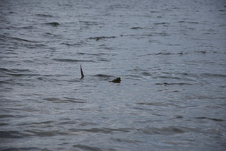
In Canadian folklore, Mussie is a creature said to live in Muskrat Lake in the Canadian province of Ontario. It is variously described, for example, as a walrus or as a three-eyed Loch Ness Monster-like creature.The legend of Mussie likely began around 1916, though legend claims that Canadian pioneer Samuel de Champlain wrote about it in the early seventeenth century. Mussie has become a part of the local culture and a fixture in the local tourism industry.

<span class="mw-page-title-main">Muskrat Lake</span> Lake in Ontario, Canada

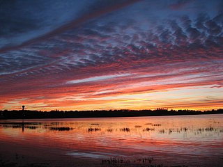
Muskrat Lake is located in the Whitewater Region of Renfrew County, in Ontario, Canada. It is approximately 16 km (9.9 mi) in length, an average of 17.9 m (59 ft) deep but 64 m (210 ft) at its deepest point, and covers an area of 1,219 ha. It is rumored to be home to a legendary lake monster that locals fondly refer to as “Mussie”. The lake currently has over 300 lakefront properties and two privately owned campgrounds surrounding its shores. The town of Cobden is the largest settlement on the lake, with a population slightly over 1,000 people.

Buttermilk Creek is a tributary of the Muskrat River in the township of Whitewater Region, Renfrew County, Ontario, Canada.

Astrolabe Lake is a lake in the township of Whitewater Region, Renfrew County, Ontario, Canada. Astrolabe Lake is where, in 1867, Edward Lee, a local farmboy, found Samuel Champlain's long lost astrolabe; a plaque now stands near the lake to commemorate this. The lake is a meeting point for the back end of both the local golf course, Oakes of Cobden, and the Logos Land waterpark. It drains via Buttermilk Creek and the Muskrat River into the Ottawa River.

King's Highway 41, commonly referred to as Highway 41, is a provincially maintained highway in the Canadian province of Ontario. The 159.6-kilometre (99.2 mi) highway travels in a predominantly north–south direction across eastern Ontario, from Highway 7 in Kaladar to Highway 148 in Pembroke. The majority of this distance crosses through a rugged forested region known as Mazinaw Country. However, the route enters the agricultural Ottawa Valley near Dacre. A significant portion of Highway 41 follows the historic Addington Colonization Road, built in 1854.

<span class="mw-page-title-main">Chapeau, Quebec</span>

Chapeau is a village in the Canadian province of Quebec, located along the Culbute Channel of the Ottawa River in the municipality of L'Isle-aux-Allumettes in Pontiac Regional County Municipality.

<span class="mw-page-title-main">Pembroke, Ontario</span> City in Ontario, Canada

Pembroke is a city in the Canadian province of Ontario at the confluence of the Muskrat River and the Ottawa River in the Ottawa Valley. Pembroke is the location of the administrative headquarters of Renfrew County, though the city itself is politically independent. It is 145 kilometres (90 mi) northwest of Ottawa.

<span class="mw-page-title-main">Waltham, Quebec</span> Municipality in Quebec, Canada

Waltham, also known as Waltham Station is a village and municipality in the Outaouais region, Quebec, Canada, part of the Pontiac Regional County Municipality. It is located at the mouth of the Noire River, along the north shore of the Ottawa River at Allumette Island.

<span class="mw-page-title-main">Sheenboro</span> Municipality in Quebec, Canada

Sheenboro is a village and municipality in the Outaouais region, part of the Pontiac Regional County Municipality, Quebec, Canada. It was formerly known as Sheen-Esher-Aberdeen-et-Malakoff. Its territory stretches along the north shore of the Ottawa River from Chichester to Rapides-des-Joachims.

<span class="mw-page-title-main">L'Isle-aux-Allumettes</span> Municipality in Quebec, Canada

L'Isle-aux-Allumettes is a municipality in the Outaouais region, part of the Pontiac Regional County Municipality, Quebec, Canada. The municipality consists primarily of Allumette Island, and also includes Morrison Island, Marcotte Island, and some minor islets, all in the Ottawa River north of Pembroke.

Nicolas de Vignau was a companion of Samuel de Champlain in New France. Champlain said of him in his writings "[He is] the most impudent liar that has been seen for a long time".

<span class="mw-page-title-main">Green's Creek (Ontario)</span> River in Ontario, Canada

Green's Creek is a small tributary of the Ottawa River that flows through the community of Gloucester in eastern Ottawa, Ontario, Canada. Among its tributaries are Borthwick Creek, Black Creek, Mud Creek, and Ramsay Creek, all of which spring in the Mer Bleue bog.

References

  1. "Census of Population". Statistics Canada . Retrieved 4 November 2023.
  2. Population calculated by combining Dissemination Blocks 35470243003 - 35470243007 and 35470244001 - 35470244019
  3. "Distance between Ottawa, ON and Cobden, ON". www.distance-cities.com. Retrieved 9 December 2023.