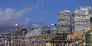
Darling Harbour is a harbour adjacent to the city centre of Sydney, New South Wales, Australia that is made up of a large recreational and pedestrian precinct that is situated on western outskirts of the Sydney central business district.

Port Jackson, consisting of the waters of Sydney Harbour, Middle Harbour, North Harbour and the Lane Cove and Parramatta Rivers, is the ria or natural harbour of Sydney, New South Wales, Australia. The harbour is an inlet of the Tasman Sea. It is the location of the Sydney Opera House and Sydney Harbour Bridge. The location of the first European settlement and colony on the Australian mainland, Port Jackson has continued to play a key role in the history and development of Sydney.

Sydney Cove is a small bay on the southern shore of Sydney Harbour, one of several harbours in Port Jackson, on the coast of Sydney, New South Wales.
Greenwich is a suburb on the Lower North Shore of Sydney, in the state of New South Wales, Australia. Greenwich is located 7 kilometres (4.3 mi) north-west of the Sydney central business district, in the local government area of the Municipality of Lane Cove.

Kirribilli is a suburb of Sydney, in the state of New South Wales, Australia. One of the city's most established and affluent neighbourhoods, it is located three kilometres north of the Sydney central business district, in the local government area administered by North Sydney Council. Kirribilli is a harbourside suburb, sitting on the Lower North Shore of Sydney Harbour. Kirribilli House is one of the two official residences of the Prime Minister of Australia.

Woolloomooloo is a harbourside, inner-city eastern suburb of Sydney, New South Wales, Australia. Woolloomooloo is 1.5 kilometres east of the Sydney central business district, in the local government area of the City of Sydney. It is in a low-lying, former docklands area at the head of Woolloomooloo Bay, on Sydney Harbour. The Domain sits to the west, the locality of East Sydney is near the south-west corner of the suburb and the locality of Kings Cross is near the south-east corner. Potts Point is immediately to the east.

Manly is a beach-side suburb of northern Sydney, in the state of New South Wales, Australia. It is 17 kilometres (11 mi) north-east of the Sydney central business district and is currently one of the three administrative centres of the local government area of Northern Beaches Council. Manly has a long-standing reputation as a tourist destination, owing to its attractive setting on the Pacific Ocean and easy accessibility by ferry.

Lavender Bay is a harbourside suburb on the lower North Shore of Sydney, New South Wales, Australia. Lavender Bay is located 3 kilometres north of the Sydney central business district, in the local government area of North Sydney Council.

Pyrmont is an inner-city suburb of Sydney, in the state of New South Wales, Australia 2 kilometres south-west of the Sydney central business district in the local government area of the City of Sydney. It is also part of the Darling Harbour region. As of 2011, it is Australia's most densely populated suburb.

Double Bay is a harbourside eastern suburb of Sydney, in the state of New South Wales, Australia 4 kilometres east of the Sydney central business district. It is the administrative centre of the local government area of the Municipality of Woollahra.

Farm Cove is a tidal inlet and shallow bay in Sydney Harbour, separated from Sydney Cove by Bennelong Point. Known to the indigenous inhabitants of Sydney as Woccanmagully, Farm Cove was used by them as an initiation ground and for the "Kangaroo and Dog Dance".

Darling Point is a harbourside eastern suburb of Sydney, Australia. It is 4 kilometres east of the Sydney central business district and is part of the local government area of Woollahra Council.

Barangaroo is an inner-city suburb of Sydney, New South Wales, Australia. It is located on the north-western edge of the Sydney central business district and the southern end of the Sydney Harbour Bridge. It is part of the local government area of the City of Sydney; it was part of the territory of the Cadigal people, the traditional owners of the Sydney city region. The area was used for fishing and hunting by Indigenous Australians prior to colonial settlement. The area is inclusive of The Hungry Mile, the name harbourside workers gave to the docklands area of Darling Harbour East during The Great Depression, where workers would walk from wharf to wharf in search of a job, often failing to find one.

Double Bay ferry services connect wharves in Sydney's Eastern Suburbs with Circular Quay by commuter ferry. The services are provided by Sydney Ferries, an agency of the Government of New South Wales. The route is coloured dark green on the current Sydney Ferries network map. SuperCats are the primary vessel on the route with some Double Bay services operated by First Fleet ferries.

Kurraba Point is a harbourside suburb on the lower North Shore of Sydney, New South Wales, Australia. Kurraba Point is located 4 kilometres north of the Sydney central business district, in the local government area of North Sydney Council.
James Bloodsworth was a convict sentenced for the theft of one game cock and two hens at Esher, Surrey. James was a master bricklayer and builder responsible for the construction of most of the buildings in the colony of New South Wales between 1788 and 1800. James Bloodsworth was living at Kingston upon Thames, England and been tried at Kingston upon Thames Quarter Sessions on the 3 October 1785, when sentenced to seven years' transportation.

Tumbalong Park is a park in Darling Harbour, located in Sydney, Australia. The parkland was designed using native Australian foliage incorporated with fountains as an urban stream. The name "Tumbalong" is from Dharug as spoken by the Eora nation and means "place where seafood is found".
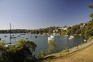
Mosman Bay is a bay of Sydney Harbour adjacent to the suburb of Mosman, 4 km north-east of the Sydney CBD in New South Wales, Australia. Three ferry wharves, Mosman Bay, South Mosman and Old Cremorne, are within the bay, all being served by the F6 Mosman Bay ferry service.
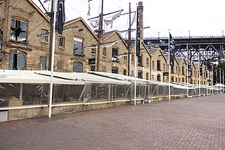
The Campbell's Stores is a heritage-listed former warehouse building in the inner city Sydney suburb of The Rocks in the City of Sydney local government area of New South Wales, Australia. The Victorian Georgian building previously served as store houses and maritime bonded warehouses. It was built from 1850 to 1861. It faces Campbells Cove, an inlet in the north-west of Sydney Cove. In the 1970s, along with the general decline of commercial shipping activities in Sydney Cove, the building was converted for use as tourist-orientated restaurants and bars.

Sydney Cove West Archaeological Precinct is a heritage-listed precinct that contains The Rocks police station, the Museum of Contemporary Art Australia, car park, parks, shops and roads located at 112-156 George Street, in the inner city Sydney suburb of The Rocks in the City of Sydney local government area of New South Wales, Australia. The precinct previously contained a commissariat store, Maritime Services Board offices, dockyard and Department of Labour & Industry offices. Buildings in the precinct were developed in various stages since 1797 to date, with heritage-listed buildings dating from 1797 to 1939. The precinct is also known as the Museum of Contemporary Art, Maritime Services Board, Colonial Government naval dockyard, Commissariat Stores, Colonial Hospital, Kings and Queens Wharf and First Fleet Park. The property is owned by Property NSW, an agency of the Government of New South Wales. It was added to the New South Wales State Heritage Register on 5 August 2011.

