
Brooks County is a county located in the U.S. state of Georgia, on its southern border with Florida. As of the 2020 census, the population was 16,301. The county seat is Quitman. The county was created in 1858 from portions of Lowndes and Thomas counties by an act of the Georgia General Assembly and was named for pro-slavery U.S. Representative Preston Brooks, after he severely beat abolitionist Senator Charles Sumner with a cane for delivering a speech attacking slavery.

St. Simons Island is a barrier island and census-designated place (CDP) located on St. Simons Island in Glynn County, Georgia, United States. The names of the community and the island are interchangeable, known simply as "St. Simons Island" or "SSI", or locally as "The Island". St. Simons is part of the Brunswick metropolitan statistical area, and according to the 2020 U.S. census, the CDP had a population of 14,982. Located on the southeast Georgia coast, midway between Savannah and Jacksonville, St. Simons Island is both a seaside resort and residential community. It is the largest of Georgia's renowned Golden Isles. Visitors are drawn to the Island for its warm climate, beaches, variety of outdoor activities, shops and restaurants, historical sites, and natural environment.
Plantations are farms specializing in cash crops, usually mainly planting a single crop, with perhaps ancillary areas for vegetables for eating and so on. Plantations, centered on a plantation house, grow crops including cotton, cannabis, coffee, tea, cocoa, sugar cane, opium, sisal, oil seeds, oil palms, fruits, rubber trees and forest trees. Protectionist policies and natural comparative advantage have sometimes contributed to determining where plantations are located.
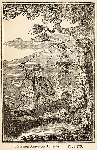
The legal institution of human chattel slavery, comprising the enslavement primarily of Africans and African Americans, was prevalent in the United States of America from its founding in 1776 until 1865, predominantly in the South. Slavery was established throughout European colonization in the Americas. From 1526, during the early colonial period, it was practiced in what became Britain's colonies, including the Thirteen Colonies that formed the United States. Under the law, an enslaved person was treated as property that could be bought, sold, or given away. Slavery lasted in about half of U.S. states until abolition in 1865, and issues concerning slavery seeped into every aspect of national politics, economics, and social custom. In the decades after the end of Reconstruction in 1877, many of slavery's economic and social functions were continued through segregation, sharecropping, and convict leasing.

Amelia Island is a part of the Sea Islands chain that stretches along the East Coast of the United States from South Carolina to Florida; it is the southernmost of the Sea Islands, and the northernmost of the barrier islands on Florida's Atlantic coast. Lying in Nassau County, Florida, it is 13 miles (21 km) long and approximately 4 miles (6.4 km) wide at its widest point. The communities of Fernandina Beach, Amelia City, and American Beach are located on the island.

The colonial period of South Carolina saw the exploration and colonization of the region by European colonists during the early modern period, eventually resulting in the establishment of the Province of Carolina by English settlers in 1663, which was then divided to create the Province of South Carolina in 1710. European settlement in the region of modern-day South Carolina began on a large scale after 1651, when frontiersmen from the English colony of Virginia began to settle in the northern half of the region, while the southern half saw the immigration of plantation owners from Barbados, who established slave plantations which cultivated cash crops such as tobacco, cotton, rice and indigo.
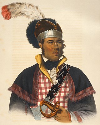
William McIntosh, also commonly known as Tustunnuggee Hutke, was one of the most prominent chiefs of the Creek Nation between the turn of the 19th-century and his execution in 1825. He was a chief of Coweta town and commander of a mounted police force. He became a large-scale planter, built and managed a successful inn, and operated a commercial ferry business.
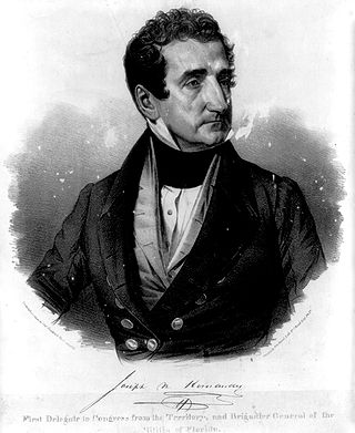
Joseph Marion Hernández was a slave-owning American planter, politician and military officer. He was the first delegate from the Florida Territory and the first Hispanic American to serve in the United States Congress. A member of the Democratic-Republican Party, he served from September 1822 to March 1823.

Partus sequitur ventrem was a legal doctrine passed in colonial Virginia in 1662 and other English crown colonies in the Americas which defined the legal status of children born there; the doctrine mandated that children of enslaved mothers would inherit the legal status of their mothers. As such, children of enslaved women would be born into slavery. The legal doctrine of partus sequitur ventrem was derived from Roman civil law, specifically the portions concerning slavery and personal property (chattels), as well as the common law of personal property; analogous legislation existed in other civilizations including Medieval Egypt in Africa and Korea in Asia.
A plantation house is the main house of a plantation, often a substantial farmhouse, which often serves as a symbol for the plantation as a whole. Plantation houses in the Southern United States and in other areas are known as quite grand and expensive architectural works today, though most were more utilitarian, working farmhouses.
Sawpit Bluff was a small settlement in East Florida during the American Revolutionary War on the site of a plantation at the mouth of Sawpit Creek where it discharges into Nassau Sound opposite the south end of Amelia Island. It was the location of a proposed rendezvous between mounted militia from Sunbury, Georgia and Continental troops under the command of Lt. Col. Samuel Elbert during the second invasion of Florida in May 1777.
The forced-labor farms of Leon County were numerous and vast. Leon County, Florida, was a hub of cotton production. From the 1820s through 1850s Leon County's fertile red clay soils and long growing season attracted cotton planters from Georgia, Virginia, Maryland, North and South Carolina, among other states as well as countries abroad.

John E. Coffee was a military leader and a Congressman for the state of Georgia.

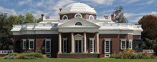
Tuckahoe, also known as Tuckahoe Plantation, or Historic Tuckahoe is located in Tuckahoe, Virginia on Route 650 near Manakin Sabot, Virginia, overlapping both Goochland and Henrico counties, six miles from the town of the same name. Built in the first half of the 18th century, it is a well-preserved example of a colonial plantation house and is particularly distinctive as a colonial prodigy house. Thomas Jefferson is also recorded as having spent some of his childhood here. It was declared a National Historic Landmark in 1969.
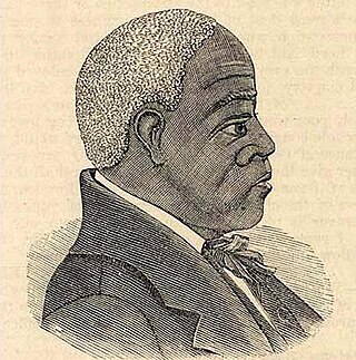
Andrew Bryan (1737–1812) founded Bryan Street African Baptist Church, affectionately called the Mother Church of Black Baptists, and First African Baptist Church of Savannah in Savannah, Georgia, the first black Baptist churches to be established in America. Bryan was formerly enslaved by Jonathan Bryan.

Plantation complexes were common on agricultural plantations in the Southern United States from the 17th into the 20th century. The complex included everything from the main residence down to the pens for livestock. Until the abolition of slavery, such plantations were generally self-sufficient settlements that relied on the forced labor of enslaved people.
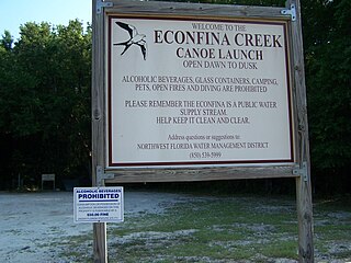
Econfina Creek is a small river in the middle Florida Panhandle. It flows through hilly country, and has sections of whitewater rapids. Much of its flow comes from springs. The river ends at Deer Point Lake, a reservoir that provides the freshwater supply for Panama City and much of Bay County.
The Alabama Baptist Association (ABA) was an association of Baptist churches founded on 15 December 1819 by four churches: the Antioch Baptist Church and the Baptist churches of Old Elam, Bethel, and Rehoboth.

Joseph Branch, also referred to as Josephus Branch, was an American lawyer and politician who served as the first Florida Attorney General.

Benjamin Chaires Sr. (1786–1838) was an American planter, land owner, banker and investor in Territorial Florida, and may have been the richest man in Florida in the 1830s. He was involved in the creation of the first railroads in Florida.
