
Blaenavon is a town and community in Torfaen county borough, Wales, high on a hillside on the source of the Afon Lwyd. It is within the boundaries of the historic county of Monmouthshire and the preserved county of Gwent. The population is 6,055.

The Black Mountains are a group of hills spread across parts of Powys and Monmouthshire in southeast Wales, and extending across the England–Wales border into Herefordshire. They are the easternmost of the four ranges of hills that comprise the Brecon Beacons National Park, and are frequently confused with the westernmost, which is known as the Black Mountain. The Black Mountains may be roughly defined as those hills contained within a triangle defined by the towns of Abergavenny in the southeast, Hay-on-Wye in the north and the village of Llangors in the west. Other gateway towns to the Black Mountains include Talgarth and Crickhowell. The range of hills is well known to walkers and ramblers for the ease of access and views from the many ridge trails, such as that on the Black Hill in Herefordshire, at the eastern edge of the massif. The range includes the highest public road in Wales at Gospel Pass, and the highest point in southern England at Black Mountain.

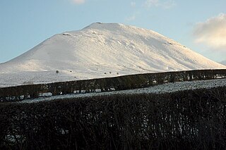
Blorenge, also called The Blorenge, is a prominent hill overlooking the valley of the River Usk near Abergavenny, Monmouthshire, southeast Wales. It is situated in the southeastern corner of the Brecon Beacons National Park. The summit plateau reaches a height of 561 metres (1,841 ft).

The Black Mountain is a mountain range in South, Mid and West Wales, straddling the county boundary between Carmarthenshire and Powys and forming the westernmost range of the Brecon Beacons National Park. Its highest point is Fan Brycheiniog at 802 metres or 2,631 ft. The Black Mountain also forms a part of the Fforest Fawr Geopark.

Allt yr Esgair is a hill in the Brecon Beacons National Park in Powys, Wales. It is commonly referred to locally as simply 'The Allt'. The Welsh name signifies 'wooded slope of the ridge'. It takes the form of a northwest-southeast aligned ridge which rises to a height of 393m and which overlooks the valley of the River Usk to the west and south. To the northeast are panoramic views across Llangorse Lake to the Black Mountains There is a viewfinder on the summit erected as a monument to Eirene Lloyd White, Baroness White of Rhymney. It is a Marilyn with a prominence of 199 metres.

Picws Du is the second highest peak of the Carmarthen Fans in the Carmarthenshire section of the Black Mountain in the west of the Brecon Beacons National Park in south Wales. The highest peak is Fan Foel immediately next along the ridge and it is a subsidiary summit of Fan Brycheiniog. Picws Du falls within Fforest Fawr Geopark and its prominent summit is marked by a large Bronze Age round barrow at a height of 2457 feet above sea level. Waun Lefrith is the other, lower summit of the Bannau Sir Gâr / Carmarthen Fans situated to the west. The peak overlooks the glacial lake of Llyn y Fan Fach in the cwm below. As the peak sits on the edge of the escarpment on a ridge which juts out into the valley below, the views from the summit are panoramic and extensive. The views to the north are especially impressive when the weather is clear, looking towards the Cambrian Mountains, Mynydd Epynt and Brecon. Swansea and the Bristol Channel can just be seen on the horizon to the south, across the gently falling dip slope. Pen y Fan and Corn Du are distinctive landmarks seen directly to the east across Fforest Fawr.
Mynydd Troed is a hill in the Black Mountains of the Brecon Beacons National Park in Powys, south Wales. Its name literally translates to "Foot Mountain," based how it appears when viewed from the Allt Mawr ridge.

Mynydd Carn-y-cefn is the name given to the broad ridge of high ground between the Ebbw Vale and the valley of the Ebbw Fach in the Valleys region of South Wales. It lies within the unitary area of Blaenau Gwent, formerly Monmouthshire.
Hatterrall Hill is a rounded peak in the Black Mountains which sits on the Wales-England border, partly in Monmouthshire, Wales and partly in Herefordshire, England. Its summit at 531m is the high point of a peaty plateau which falls away steeply on all sides. Broad ridges run to the north, the southeast and southwest. To the north the ridge dips to a col at around 485m elevation before rising gradually over several kilometres towards Crib y Garth / Black Hill and Hay Bluff. The ridge to the southwest ends abruptly at the sheer cliff known as the Darren below which is a considerable landslip area extending south to the hamlet of Cwmyoy with its mis-shapen church. The Welsh part of the hill falls within the Brecon Beacons National Park.

Mynydd Merthyr is a broad ridge of high ground between Taff Vale and the Cwm Cynon in the Valleys region of South Wales. It forms the boundary between the unitary authorities of Rhondda Cynon Taff to the west and Merthyr Tydfil to the east.

Mynydd Cilfach-yr-encil attains a height of 445m at OS grid reference SO 079033 making it the high point of the broad ridge of high ground between Taff Vale and Cwm Bargod in the Valleys region of South Wales. It lies within the unitary area of Merthyr Tydfil.
Mynydd Bedwellte is the name given to the broad ridge of high ground between the Rhymney Valley and the Sirhowy Valley in the Valleys region of South Wales. It straddles the boundary of the unitary areas of Caerphilly and Blaenau Gwent.
Cefn y Brithdir is the name given to the broad ridge of high ground between the Rhymney Valley and Cwm Darran in the Valleys region of South Wales. It lies within the unitary area of Caerphilly.
The geology of Monmouthshire in southeast Wales largely consists of a thick series of sedimentary rocks of different types originating in the Silurian, Devonian, Carboniferous, Triassic and Jurassic periods.

Mynydd y Drum is a hill on the border between the county of Powys and Neath Port Talbot County Borough, south Wales. The summit of the hill is in Neath Port Talbot at 298m and lies towards the western end of a broad curving ridge, the larger part of which is in Powys. The eastern half of the hill is currently being opencasted for coal. The hill is sometimes referred to simply as The Drum.

Mynydd Twyn-glas is a sprawling 472-metre-high mountain extending into Caerphilly and Torfaen county boroughs in South Wales. It lies southwest of Pontypool, west of Cwmbran and east of Newbridge and taking the form of a rolling plateau the margins of which are defined by steep slopes, many of which are cloaked with conifer plantations. A broad shoulder extending south from the summit is known as Mynydd Maen whilst to the north is Mynydd Llwyd. The thickly afforested northern slopes of the hill drop down steeply into Cwm y Glyn.

The Pwll Du Tunnel was the longest horse-powered tramway tunnel to be built in Britain at 1,875 metres (6,152 ft) in length. It started in Blaenavon, Torfaen, Wales, and was originally a coal mine, running northward almost horizontally into a hillside. Later it was extended right through the hill and used to carry limestone from quarries at Pwll Du and Tyla to the ironworks at Blaenavon, and to carry pig iron from Blaenavon to the Garnddyrys Forge. The tramway was extended past Garnddyrys to Llanfoist Wharf on the Brecknock and Abergavenny Canal. The tramway from Pwll Du to the canal fell out of use when the railway came to Blaenavon and the Garnddyrys forge was closed in 1860, but the tunnel continued to be used to carry limestone to Blaenavon until 1926. It is now a scheduled monument and part of a UNESCO World Heritage Site.
This article describes the geology of the Brecon Beacons National Park in mid/south Wales. The area gained national park status in 1957 with the designated area of 1,344 km2 (519 sq mi) including mountain massifs to both the east and west of the Brecon Beacons proper. The geology of the national park consists of a thick succession of sedimentary rocks laid down from the late Ordovician through the Silurian and Devonian to the late Carboniferous period. The rock sequence most closely associated with the park is the Old Red Sandstone from which most of its mountains are formed. The older parts of the succession, in the northwest, were folded and faulted during the Caledonian orogeny. Further faulting and folding, particularly in the south of the park is associated with the Variscan orogeny.
Mynydd Garnclochdy is a gentle summit on the long moorland ridge which extends south from the Blorenge towards Pontypool and which defines the boundary between the modern county of Monmouthshire to the east and the county borough of Torfaen to the west though historically it was entirely within the traditional county of Monmouthshire. Its summit, at a height of 448 m (1407 ft), is marked by a small cairn. The summit and the eastern slopes of the hill fall within the Brecon Beacons National Park. A southern top of the hill, Mynydd Garn-wen achieves a height of 436m, and carries a trig point further south again at an elevation of 425m. To the north the broad moorland ridge runs via a poorly defined 425m top and a col at 404m elevation just south of a minor east–west road, into Mynydd y Garn-fawr, east of Blaenavon.

The Dog Stone, on Mynydd Farteg, a subsidiary top of Coity Mountain, near the village of Abersychan, Torfaen, Wales, is a memorial, dating from 1864, to "Carlo", a Red setter. It is a Grade II listed structure.
