Billingsgate is one of the 25 Wards of the City of London. This small City Ward is situated on the north bank of the River Thames between London Bridge and Tower Bridge in the south-east of the Square Mile.

Blackwall is an area of Poplar, in the London Borough of Tower Hamlets, East London. The neighbourhood includes Leamouth and the Coldharbour conservation area.

Sir Walter Besant was an English novelist and historian. William Henry Besant was his brother, and another brother, Frank, was the husband of Annie Besant.

Baynard's Castle refers to buildings on two neighbouring sites in the City of London, between where Blackfriars station and St Paul's Cathedral now stand. The first was a Norman fortification constructed by Ralph Baynard, 1st feudal baron of Little Dunmow in Essex, and was demolished by King John in 1213. The second was a medieval palace built a short distance to the south-east and later extended, but mostly destroyed in the Great Fire of London in 1666. According to Sir Walter Besant, "There was no house in [London] more interesting than this".
Tower Hill is the area surrounding the Tower of London in the London Borough of Tower Hamlets. It is infamous for the public execution of high status prisoners from the late 14th to the mid 18th century. The execution site on the higher ground north-west of the Tower of London moat is now occupied by Trinity Square Gardens.

East London is the northeastern part of London, United Kingdom. Located east of the ancient City of London and north of the River Thames as it begins to widen, East London developed as London's docklands and the primary industrial centre. The expansion of railways in the 19th century encouraged the eastward expansion of the East End of London and a proliferation of new suburbs. The industrial lands of East London are today an area of regeneration, which are well advanced in places such as Canary Wharf and ongoing elsewhere.

Gropecunt Lane was a street name found in English towns and cities during the Middle Ages, believed to be a reference to the prostitution centred on those areas; it was normal practice for a medieval street name to reflect the street's function or the economic activity taking place within it. Gropecunt, the earliest known use of which is in about 1230, appears to have been derived as a compound of the words grope and cunt. Streets with that name were often in the busiest parts of medieval towns and cities, and at least one appears to have been an important thoroughfare.

A waterman is a river worker who transfers passengers across and along city centre rivers and estuaries in the United Kingdom and its colonies. Most notable are those on the River Thames and River Medway in England, but other rivers such as the River Tyne and River Dee, Wales, also had their watermen who formed guilds in medieval times. Waterman can also be a person who navigates a boat carrying passengers. These boats were often rowing boat or boats with sails. Over the years watermen acquired additional skills such as local pilotage, mooring vessels at berths, jetties, buoys, and docks, and acting as helmsman aboard large vessel.

Durham House, or Durham Inn, was the historic London town house of the Bishop of Durham in the Strand. Its gardens descended to the River Thames.

All-Hallows-the-Great was a church in the City of London, located on what is now Upper Thames Street, first mentioned in 1235. Destroyed in the Great Fire of London of 1666, the church was rebuilt by the office of Sir Christopher Wren. All-Hallows-the-Great was demolished in 1894 when many bodies were disinterred from the churchyard and reburied at Brookwood Cemetery.

St Faith under St Paul's in Castle Baynard Ward was an unusual parish within the City of London. It originally had its own building to the east of St Paul's Cathedral, serving as a parish church for the residents of St Paul's Churchyard and Paternoster Row, but this was removed in 1256 to allow for the eastern expansion of the Cathedral. The parishioners were instead given a space to worship within the cathedral crypt.

All-Hallows-the-Less was a church in the City of London. Of medieval origin, it was destroyed in the Great Fire of London in 1666 and not rebuilt.

St Laurence Pountney was a Church of England parish church in the Candlewick ward of the City of London. It was destroyed in the Great Fire of 1666, and not rebuilt.

Thames Street, divided into Lower and Upper Thames Street, is a road in the City of London, the historic and financial centre of London. It forms part of the busy A3211 route from Tower Hill to Westminster. The London Bridge underpass marks the divide between Upper and Lower Thames Street, with Lower to the east and Upper to the west.

Samuel Pountney Smith JP was an English architect who practised in Shrewsbury, Shropshire, England.

Coldharbour is a street and wider conservation area in Blackwall, lying on the north bank of the River Thames, east of Canary Wharf. The area is said to be "[t]he sole remaining fragment of the old hamlet of Blackwall" and "one of the last examples of the narrow streets which once characterised the river's perimeter".
Sir Nicholas de Loveyne was a major English property owner and courtier, who held a number of senior positions in the service of King Edward III.

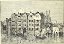
Sir John de Pulteney was a major English entrepreneur and property owner, who served four times as Mayor of London.

The "Copperplate" map of London is an early large-scale printed map of the City of London and its immediate environs, surveyed between 1553 and 1559, which survives only in part. It is the earliest true map of London. The original map was probably designed for hanging on a wall, and is believed to have measured approximately 3 feet 8 inches (112 cm) high by 7 feet 5 inches (226 cm) wide. No copies of the printed map itself are known to have survived; but between 1962 and 1997 three of the original engraved copper printing-plates – from a probable total of 15 – were identified. Although only a fragmentary portion of the map is known, the three plates cover the greater part of the built-up heart of the City of London.

Seething Lane is a street in the City of London. It connects All Hallows-by-the-Tower, Byward Street, with St Olave's Church, Hart Street. The street is named after an Old English expression meaning "full of chaff", which was derived from the nearby corn market in Fenchurch Street. Samuel Pepys lived there and is buried in St Olave's Church at the junction with Hart Street. A bust of Pepys, created by Karin Jonzen, sits in the public garden at the south end of the street.