
100 Mile House is a town and district municipality located in the South Cariboo region of central British Columbia, Canada.

Lillooet, formerly Cayoosh Flat, is a community on the Fraser River in British Columbia, Canada, about 240 kilometres (150 mi) up the British Columbia Railway line from Vancouver. Situated at an intersection of deep gorges in the lee of the Coast Mountains, it has a dry climate with an average of 329.5 millimetres (13 in) of precipitation being recorded annually. Lillooet has a long growing season, and once had prolific market gardens and orchard produce. It often vies with Lytton and Osoyoos for the title of "Canada's Hot Spot" on a daily basis in summer.
Highway 97 is the longest continuously numbered route in the Canadian province of British Columbia, running 2,081 km (1,293 mi) from the Canada–United States border near Osoyoos in the south to the British Columbia/Yukon boundary in the north at Watson Lake, Yukon. The route takes its number from U.S. Route 97, with which it connects at the international border. The highway was initially designated '97' in 1953.
Highway 26, also known as the Barkerville Highway, is a minor east-west highway in the North Cariboo region of the Central Interior of British Columbia, Canada. First opened in 1967, it provides access to the community of Wells and the famous gold rush town of Barkerville at the foot of the Cariboo Mountains, respectively 75 and 81 km east of the highway's junction with Highway 97 at Quesnel. Also accessed by the route is Bowron Lakes Provincial Park, a popular canoeing expedition circuit, the cutoff for which is between Barkerville and Wells. Since Highway 26 is very lightly travelled, it has not needed any major improvements since its opening. Its route is approximately the same as that of the Cariboo Wagon Road.

Williams Lake is a city in the Central Interior of British Columbia, in the central part of a region known as the Cariboo. Williams Lake is the second largest city, by population of metropolitan area, in the Cariboo after neighbouring Quesnel. The city is famous for its Williams Lake Stampede, the second largest professional rodeo in Canada after only the Calgary Stampede.

The Cariboo Gold Rush was a gold rush in the Colony of British Columbia, which later joined the Canadian province of British Columbia. The first gold discovery was made at Hills Bar in 1858, followed by more strikes in 1859 on the Horsefly River, and on Keithley Creek and Antler Creek in 1860. The actual rush did not begin until 1861, when these discoveries were widely publicized. By 1865, following the strikes along Williams Creek, the rush was in full swing.

The Douglas Road, a.k.a. the Lillooet Trail, Harrison Trail or Lakes Route, was a goldrush-era transportation route from the British Columbia Coast to the Interior. Over 30,000 men are reckoned to have travelled the route in, although by the end of the 1860s it was virtually abandoned due to the construction of the Cariboo Wagon Road, which bypassed the region.
Cariboo was one of the twelve original electoral districts created when British Columbia became a Canadian province in 1871. Roughly corresponding to the old colonial electoral administrative district of the same name, it was a three-member riding until the 1894 election, when it was reduced through reapportionment and became a two-member riding until the 1916 election, after which it has been a single-member riding. It produced many notable Members of the Legislative Assembly (MLAs), including George Anthony Boomer Walkem, third and fifth holder of the office of Premier of British Columbia and who was one of the first representatives elected from the riding; John Robson, ninth Premier of British Columbia; and Robert Bonner, a powerful minister in the W.A.C. Bennett cabinet, and later CEO of MacMillan Bloedel and BC Hydro.

Alexandra Bridge Provincial Park is a provincial park located in the Fraser Canyon of British Columbia, Canada. It was established on March 26, 1984 to preserve a historically significant suspension bridge spanning the Fraser River.
Clinton is a village in British Columbia, Canada, located approximately 40 km (25 mi) northwest of Cache Creek and 30 km south of 70 Mile House.
New York State Route 242 (NY 242) is a state highway that runs across Cattaraugus County, New York, in the United States. Although signed as an east–west route, it takes a more northeast–southwest course across the county from NY 394 near the hamlet of Randolph in the town of Coldspring to NY 16 in Machias. The western end between Randolph and Little Valley was the western half of the short-lived New York State Route 17H. The eastern half of NY 17H was the southern end of NY 353 from Little Valley to Salamanca.
Soda Creek is a rural subdivision 38 km north of Williams Lake in British Columbia, Canada. Located on the east bank of the Fraser River, Soda Creek was originally the home of the Xat'sull First Nation. Soda Creek Indian Reserve No. 1 is located on the left (E) bank of the Fraser River, one mile south of the Soda Creek BCR (CN) station, 431.10 ha. 52°19′00″N122°16′00″W
The Old Cariboo Road is a reference to the original wagon road to the Cariboo gold fields in what is now the Canadian province of British Columbia. It should not be confused with the Cariboo Road, which was built slightly later and used a different route.
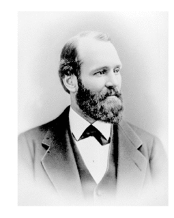
Gustavus Blin Wright was a pioneer roadbuilder and entrepreneur in British Columbia, Canada. His biggest achievement was building the Old Cariboo Road to the Cariboo gold fields, from Lillooet to Fort Alexandria, but he was also a partner in a freighting firm that operated on the Douglas Road, he ran a toll bridge at Bridge River, near Lillooet, and built part of the road from Quesnel to Barkerville. He was also the original owner of the town of 70 Mile House.
Lac La Hache is a recreational and retirement community in the Cariboo region of British Columbia, Canada. Located on the shore of Lac La Hache alongside British Columbia Highway 97 near the regional centre of 100 Mile House, the community's origins date to the days of the Cariboo Gold Rush and the Cariboo Wagon Road, for which it provided an important roadhouse. Lac La Hache, or "The Lake of the Axe" as it translates to, was named, during the fur trade era, after the unfortunate incident of a French-Canadian voyageur who lost his axe head while chopping a hole in the ice. It is a town rich in history, as it sits along the Gold Rush Trail.

The Interlakes, also known as the Interlakes District, is a geographic region of the Interior of British Columbia, Canada, located along and around the Interlakes Highway between 100 Mile House on BC Highway 97 and Little Fort on the North Thompson River. The area is a subregion of the Cariboo and includes the communities of Bridge Lake and Lac des Roches.

A roadhouse or stopping house (Canada) is a small mixed-use premises typically built on or near a major road in a sparsely populated area or an isolated desert region that services the passing travellers, providing food, drinks, accommodation, fuel and parking spaces to the guests and their vehicles. The premises generally consist of just a single dwelling, permanently occupied by a nuclear family, usually between two and five family members.
Cottonwood River is a tributary of the Fraser River in the Central Interior of British Columbia, Canada. Rising at the confluence of the Swift River and Lightning Creek at Coldspring House in the Cariboo goldfields of the northern Cariboo Plateau, it flows northwest and then turns southwest to join the Fraser just north of the city of Quesnel, which is at the confluence of the Quesnel River with the Fraser.

Cottonwood, including the Cottonwood Ranch and Cottonwood House, is an unincorporated settlement in the North Cariboo region of the Central Interior of British Columbia, Canada. Originally a ranch, it is located in the northern Cariboo Plateau, just 8 km northwest of Coldspring House, which is at the confluence of the Swift River and Lightning Creek, which is the beginning of the Cottonwood River. Lightning Creek was one of the more famous of the gold-bearing creeks of the Cariboo Gold Rush.
Beaver Pass House is an unincorporated locality and former roadhouse on the Cariboo Wagon Road in the Cariboo Country of the Central Interior of British Columbia, Canada. Located on the north bank of Lightning Creek northwest of Coldspring House, another roadhouse, it still had a population of 17 in the 1961 Canadian census, in which it had been listed as Beaver Pass. By that time, the original roadhouse had been destroyed by a fire, but a gas station and coffeehouse had been built near the original location.
