College Hill, Wichita, Kansas

Last updated

College Hill
College Hill Circle Drive.jpg
The Aviary, 330 Circle Drive
Coordinates: 37°41′13″N97°17′22″W / 37.68694°N 97.28944°W / 37.68694; -97.28944
Country United States
State Kansas
County Sedgwick
City Wichita
Elevation
1,360 ft (410 m)
Population
 (2016) [1]
  Total4,893
ZIP code
67208, 67211, 67214, 67218
Area code 316

College Hill is a historical, predominantly residential neighborhood in Wichita, Kansas, United States. [2]

Contents

History

College Hill was platted as a series of developments during a real estate speculation boom of the 1880s. The name came from a proposed Methodist college that would have been located in the neighborhood at Douglas and Rutan, but the Methodist church instead choose to build its college, today known as Southwestern College, in Winfield, Kansas. While a few houses in the neighborhood were built prior to the turn of the century, most were built between 1900 and 1934. In December 1926, the Lincoln Heights Addition between Douglas and Kellogg and Oliver and Crestway consisting of 73 acres and 250 lots was placed on the market. Construction of Lincoln Heights Shopping Center at Douglas and Oliver, begun in June 1948, was completed in July 1949. [3]

Geography

College Hill is located at 37°41′13″N97°17′22″W / 37.68694°N 97.28944°W / 37.68694; -97.28944 (37.686944, -97.289444) at an elevation of 1,360 feet (410 m). [4] It comprises the area between Central Avenue to the north and U.S. Route 54 to the south and between Hillside Street to the west and Oliver Avenue to the east. [2] [5] Located approximately 2.5 miles (4 km) east of Downtown Wichita, College Hill borders the neighborhoods of Sleepy Hollow and Country Overlook to the north, Crown Heights North and Crown Heights South to the east, Fairfax and Longview to the south, and East Front and Uptown to the west. [2]

College Hill Park

View from English Street College Hill Park.jpg
View from English Street

College Hill Park is managed by the Wichita Department of Park and Recreation. The city park spans 22 acres (8.9 ha) and is located on English and Circle Drive south of Douglas Avenue. Amenities include a basketball court, playground, shuffleboard courts, swimming pool, and tennis courts. [6]

During Wichita’s real estate boom days of the 1880s, when the city was known as the "Peerless Princess of the Plains", [7] mule-drawn streetcars traveled up and down Douglas Avenue taking residents to and from work and shopping. A college was planned for the area where the park now is, and plans changed. The area that is now College Hill Park served as the Wichita Country Club from 1901–1912. It was redeveloped from an overgrown golf course into its current park configuration, including its swimming pool, via WPA funds during the Great Depression. [8]

Today, College Hill Park is a treasured place for families to stroll and play. [9]

Collge-hill-park-fall.jpg
Panoramic view of College Hill Park from the east

Government

For the purposes of representation on the Wichita City Council, College Hill lies within Council District 1. [10]

For the purposes of representation in the Kansas Legislature, College Hill is located in the 29th district of the Kansas Senate, represented by Democrat Oletha Faust-Goudeau, and the 84th district of the Kansas House of Representatives, represented by Democrat Gail Finney. [11]

Education

Wichita Public Schools operates one school in the neighborhood: College Hill Elementary School. [12] College Hill is part of the Wichita East High School and Robinson Middle School feeder systems.[ citation needed ]

The Roman Catholic Diocese of Wichita oversees one Catholic school in the neighborhood: Blessed Sacrament School. [13]

Culture

Points of interest

Transportation

Douglas Avenue is the main east-west street through College Hill. Other arterial roads include: Hillside Street, which runs north-south along the western edge of the neighborhood; Oliver Avenue, which runs north-south along the eastern edge of the neighborhood; and Central Avenue, which runs east-west along the northern edge of the neighborhood. U.S. Route 54 runs east-west immediately south of College Hill as the Kellogg Avenue freeway, accessible by interchanges at Hillside and Oliver. [5]

Wichita Transit offers bus service in College Hill on its 21, 24, and 25 routes. [14] On Fridays and Saturdays, the Douglas route of the free Q-Line trolley also services the neighborhood. [15]

Related Research Articles

<span class="mw-page-title-main">Riverside, Wichita, Kansas</span> Neighborhood in Sedgwick, Kansas, United States

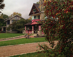
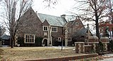
Riverside is a neighborhood in Wichita, Kansas, United States. A mostly residential area located between the Arkansas and Little Arkansas Rivers, it is home to several of the city's museums and large parks.

<span class="mw-page-title-main">Delano, Wichita, Kansas</span> Neighborhood in Sedgwick, Kansas, United States

Delano is a neighborhood located in Wichita, Kansas, United States. A mixed commercial and residential area on the west bank of the Arkansas River, it is home to Friends University, Riverfront Stadium, and Exploration Place, the Sedgwick County science museum.

Midtown is a neighborhood in Wichita, Kansas, United States. A mixed commercial and residential area on the east bank of the Little Arkansas River, it is the oldest neighborhood in the city.

<span class="mw-page-title-main">Downtown Wichita</span> Central business district in Kansas, United States

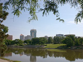
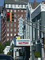
Downtown Wichita is the central business district of Wichita, Kansas, United States. The political and financial hub of the city, it is home to several of the area's major landmarks and event venues including the Epic Center, Century II Performing Arts & Convention Center, Intrust Bank Arena, and the Old Town entertainment district.

South Central is a neighborhood in Wichita, Kansas, United States. A mixed commercial and residential area on the east bank of the Arkansas River, it is among the city’s oldest neighborhoods.

<span class="mw-page-title-main">McAdams, Wichita, Kansas</span> Neighborhood in Sedgwick, Kansas, United States

McAdams is a neighborhood in Wichita, Kansas, United States. A mixed industrial and residential area northeast of Downtown Wichita, it is a historical center of the city’s African American community.

The Hyde, also known as Kellogg School, is a neighborhood in Wichita, Kansas, United States. It is a mixed commercial and residential area immediately southeast of Downtown Wichita on the west side of Interstate 135.

The following is a list of neighborhoods in Wichita, Kansas, United States.

New Salem is a neighborhood in Wichita, Kansas, United States. A predominantly residential area, it is located in the east-central part of the city on the east side of Interstate 135.

East Front is a neighborhood in Wichita, Kansas, United States. A predominantly residential area, it is located in the east-central part of the city on the north side of U.S. Route 54.

Uptown is a neighborhood in Wichita, Kansas, United States. A mixed commercial and residential area, it is located in the east-central part of the city.

Stanley/Aley is a mixed residential and industrial neighborhood in Wichita, Kansas, United States. It lies in the west-central part of the city on the south side of U.S. Route 54.

Sunflower is a mixed residential and commercial neighborhood in Wichita, Kansas, United States. It lies in the west-central part of the city on the north side of U.S. Route 54.

North Riverside is a residential neighborhood in Wichita, Kansas, United States. It lies in the north-central part of the city between the Arkansas and Little Arkansas Rivers.

Sunnyside is a neighborhood in Wichita, Kansas, United States. A predominantly residential area, it is located in the east-central part of the city on the south side of U.S. Route 54.

Northeast Heights is a neighborhood in Wichita, Kansas, United States. A mixed commercial and residential area, it is located in the northeastern part of the city.

Orchard Breeze is a mixed residential and commercial neighborhood in Wichita, Kansas, United States. It lies in the west-central part of the city on the east side of Interstate 235.

La Placita Park is a neighborhood in Wichita, Kansas, United States. A mixed commercial and residential area, it is located in the west-central part of the city.

Benjamin Hills is a neighborhood in Wichita, Kansas, United States. A mixed commercial and residential area, it lies on the north bank of the Arkansas River in the northwestern part of the city.

Westlink is a neighborhood in Wichita, Kansas, United States. A mixed commercial and residential area, it lies in the western part of the city.

References

  1. "College Hill, Wichita, Kansas". Statistical Atlas. Cedar Lake Ventures. Retrieved October 19, 2018.
  2. 1 2 3 "Neighborhood Associations - City of Wichita, Kansas" (PDF). City of Wichita. June 13, 2012. Retrieved October 27, 2012.
  3. Tihen, Edward. "Tihen Notes, Wichita Eagle, Wichita State University Libraries' Department of Special Collections, 1926 through 1949" (PDF).
  4. College Hill, Wichita, KS, Google Earth, October 27, 2012
  5. 1 2 "College Hill, Wichita, KS". Google Maps. Retrieved October 27, 2012.
  6. "College Hill Park". City of Wichita, Kansas. Retrieved September 26, 2018.
  7. http://specialcollections.wichita.edu/collections/local_history/tihen/pdf/People&Places/Peerless_Princess.PDF [ bare URL PDF ]
  8. White, Rebecca. "College Hill history part of Wichita's struggle for national status". KWCH. Archived from the original on May 29, 2015. Retrieved June 26, 2014.
  9. "College Hill Neighborhood | Traditions at Home". November 22, 2017.
  10. "Council Districts [map]" (PDF). City of Wichita. Archived from the original (PDF) on March 30, 2014. Retrieved July 7, 2014.
  11. "Kansas Data - 2012 Primary Election Districts". University of Kansas Institute for Policy & Social Research. Archived from the original on August 8, 2012. Retrieved October 27, 2012.
  12. "Directory of Buildings" (PDF). Wichita Public Schools. Retrieved September 26, 2018.
  13. "Diocesan Parish Map". Catholic Diocese of Wichita. Archived from the original on September 26, 2018. Retrieved September 26, 2018.
  14. "Bus System Map" (PDF). Wichita Transit. Retrieved September 28, 2018.
  15. "Q-Line" (PDF). Wichita Transit. Retrieved September 28, 2018.