
Harewood is a village, civil parish, former manor and ecclesiastical parish, in West Yorkshire, England, today in the metropolitan borough of the City of Leeds. The civil parish population at the 2011 census was 3,734.

Cookridge is a suburb of north-west Leeds, West Yorkshire, England, north of the Leeds Outer Ring Road. In 1715 Ralph Thoresby described it as a village four miles from Leeds and three from Otley, dating from 1540.

Meanwood is a suburb and former village in north-west Leeds, West Yorkshire, England.

Aberford is a village and civil parish on the eastern outskirts of the City of Leeds in West Yorkshire, England. It had a population of 1,059 at the 2001 census, increasing to 1,180 at the 2011 Census. It is situated 10 miles (15.5 km) east, north east of Leeds and west of the A1(M) motorway.

John Carr (1723–1807) was a prolific English architect, best known for Buxton Crescent in Derbyshire and Harewood House in West Yorkshire. Much of his work was in the Palladian style. In his day he was considered to be the leading architect in the north of England.

The Meanwood Beck is a stream in West Yorkshire, England, which flows southwards through Adel, Meanwood and Sheepscar into the River Aire in central Leeds. Different portions of the same watercourse have been referred to as Adel Beck, Carr Beck, Lady Beck, Mabgate Beck, Sheepscar Beck, Timble Beck or Wortley Beck. The Meanwood Valley Trail footpath follows the line of the beck for much of its course.
Shadwell is a village and civil parish in north-east Leeds, West Yorkshire, England. The village is 6 miles (9.7 km) to the north east of Leeds city centre.

Killingbeck is a district of east Leeds, West Yorkshire, England named after the Killingbeck family, historic local landowners, and is situated between Seacroft to the north, Cross Gates and Whitkirk to the east, Gipton to the west, Halton Moor to the south, Halton to the south-east and Osmondthorpe to the south-west.

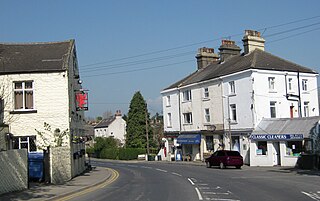
Collingham is a village and civil parish 2 miles (3 km) south-west of Wetherby in West Yorkshire, England. It is in the City of Leeds metropolitan borough. The population of the civil parish as of the 2011 census was 2,991.
Tinshill is a district of Leeds, 4 miles (7 km) north of Leeds city centre, West Yorkshire, England. It was the Danes in the 9th century who named the hill "Tyndr's Hyll".

Apperley Bridge is a village in the metropolitan borough of the City of Bradford, in West Yorkshire, England in the Idle and Thackley Ward. Apperley Bridge is north-east of Bradford on the boundary with the City of Leeds bounded in the east by Carr Beck and to the south by Greengates. The village straddles the Leeds and Liverpool Canal and the River Aire. It takes its name from the old bridge over the river on Apperley Lane.

The architecture of Leeds, a city and metropolitan borough in West Yorkshire, England, encompasses a wide range of architectural styles and notable buildings. As with most northern industrial centres, much of Leeds' prominent architecture is of the Victorian era. However, the City of Leeds also contains buildings from as early as the Middle Ages such as Kirkstall Abbey, one of Britain's best preserved ruined Cistercian monasteries, as well as examples of 20th century industrial architecture, particularly in the districts of Hunslet and Holbeck.

Chapel Allerton is an inner suburb of north-east Leeds, West Yorkshire, England, 2 miles (3.2 km) from the city centre.
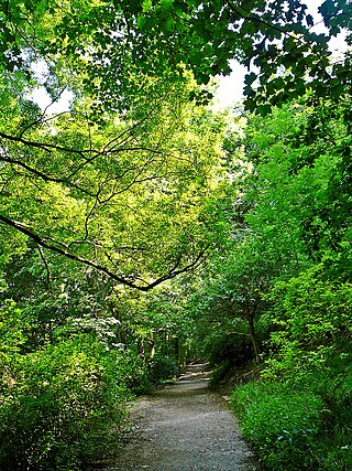
Woodhouse Ridge is a strip of woodland on the South West hillside of the Meanwood valley in urban area of Leeds, West Yorkshire, England. Locally known as 'The Ridge', the area is notable as a significant area of mature woodland in an otherwise highly developed urban area. The woods are centred at grid reference 53.820061, -1.560144 and are enclosed by Meanwood Road to the east and by Headingley to the north and Woodhouse, Leeds to the South.
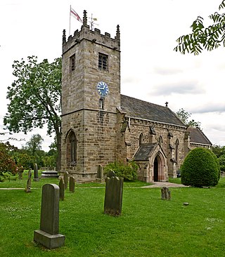
St Oswald's Church is an active Anglican church in Collingham, West Yorkshire, England. It is in the Harrogate deanery and Diocese of Leeds. The church is on the edge of the village on Wetherby Road.
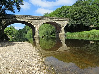
Linton Bridge carries the minor road that links Collingham and Linton over the River Wharfe near Wetherby in West Yorkshire, England.

Churwell railway station served the village of Churwell, West Yorkshire, England from 1848 to 1940 on the Huddersfield line.
Collingham is a civil parish in the metropolitan borough of the City of Leeds, West Yorkshire, England. It contains eight listed buildings that are recorded in the National Heritage List for England. Of these, one is listed at Grade II*, the middle of the three grades, and the others are at Grade II, the lowest grade. The parish contains the villages of Collingham and Linton, and the surrounding countryside. The listed buildings consist of a church, two farmhouses, a barn, an outbuilding, two bridges, and a milestone.

