
The Bahamas, officially the Commonwealth of The Bahamas, is an island country within the Lucayan Archipelago of the Atlantic Ocean. It contains 97% of the Lucayan Archipelago's land area and 88% of its population. The archipelagic country consists of more than 3,000 islands, cays, and islets in the Atlantic Ocean, and is located north of Cuba and northwest of the island of Hispaniola and the Turks and Caicos Islands, southeast of the U.S. state of Florida and east of the Florida Keys. The capital is Nassau on the island of New Providence. The Royal Bahamas Defence Force describes the Bahamas' territory as encompassing 470,000 km2 (180,000 sq mi) of ocean space.
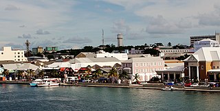
Nassau is the capital and largest city of the Bahamas. It is located on the island of New Providence, which had a population of 246,329 in 2010, or just over 70% of the entire population of the Bahamas. As of April 2023, the preliminary results of the 2022 census of the Bahamas reported a population of 296,522 for New Providence, 74.26% of the country's population. Nassau is commonly defined as a primate city, dwarfing all other towns in the country. It is the centre of commerce, education, law, administration, and media of the country.

The earliest arrival of people in the islands now known as the Bahamas was in the first millennium AD. The first inhabitants of the islands were the Lucayans, an Arawakan language-speaking Taino people, who arrived between about 500 and 800 AD from other islands of the Caribbean.
This article talks about transportation in the Bahamas, a North American archipelagic state in the Atlantic Ocean.
The Lucayan people were the original residents of The Bahamas and the Turks and Caicos Islands before the European colonisation of the Americas. They were a branch of the Taínos who inhabited most of the Caribbean islands at the time. The Lucayans were the first Indigenous Americans encountered by Christopher Columbus. Shortly after contact, the Spanish kidnapped and enslaved Lucayans with the displacement culminating in the complete eradication of the Lucayan people from the Bahamas by 1520.

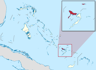
Local government in the Bahamas exists at two levels: 32 districts and 41 towns. The boundaries of districts are defined by the First Schedule of The Bahamas Local Government Act 1996, defined with reference to parliamentary constituency boundaries. The Second Schedule lists 13 districts which are divided into town areas. Towns are governed by directly elected town committees. Second Schedule districts are governed by nine-person district councils composed of the chairs of the town committees, and if numerically required, additional people elected by the town committees. The 19 Third Schedule districts are unitary authorities which cannot be divided into towns. They are governed by nine-person district councils which are directly elected by voters. The powers of Second Schedule and Third Schedule councils are slightly different, and the Third Schedule district known as the City of Freeport has a slightly different list of enumerated powers.

Cat Island is located in The Bahamas, and is one of its districts. Cat Island also has the nation's highest point, Mount Alvernia. It rises to 63 metres (207 ft) and is topped by a monastery called The Hermitage. This assembly of buildings was erected by the Franciscan "Brother Jerome".

Exuma is a district of The Bahamas, consisting of over 365 islands and cays.

Inagua is the southernmost district of the Bahamas, comprising the islands of Great Inagua and Little Inagua. The headquarters for the district council are in Matthew Town.

Acklins and Crooked Islands was a district of the Bahamas until 1996, and as Acklins, Crooked Island and Long Cay until 1999.

Ragged Island is a 23 km2 (8.9 sq mi) island and district in the southern Bahamas. Ragged Island is part of the Jumentos Cays and Ragged Island Chain. The crescent-shaped chain measures over 180 km (110 mi) in length and includes cays known as Raccoon Cay, Hog Cay and Double-Breasted Cay. Island ownership is stated to have been granted to William George Lockhart some time in the 18th century. On 8 September 2017, Duncan Town took a direct hit from Hurricane Irma.

Acklins is an island and district of the Bahamas.
Crooked Island is an island and district, part of a group of Bahamian islands defining a large, shallow lagoon called the Bight of Acklins, of which the largest are Crooked Island in the north and Acklins in the south-east, and the smaller are Long Cay in the north-west, and Castle Island in the south.

The Cuban amazon, also known as the Cuban parrot and the rose-throated parrot, is a medium-sized mainly green parrot found in woodlands and dry forests of Cuba, the Bahamas and Cayman Islands in the Caribbean. Although they have been observed in the wild in Puerto Rico, they are probably the result of escaped pets, and no reproduction has been recorded.
Colonel Hill Airport, also known as Crooked Island Airport, is an airport in Colonel Hill on Crooked Island in the Bahamas.
Long Cay is an 8-square-mile island in the Bahamas in an atoll that includes Acklins Island and Crooked Island. Since 1999, it has also been one of the Third Schedule districts of The Bahamas. As of 2010, its population was 29. Coordinates = 2235 North and 7422 West.
The following outline is provided as an overview of and topical guide to The Bahamas:

The following is an alphabetical list of topics related to the Commonwealth of The Bahamas.
Inagua National Park is a national park on the island of Great Inagua in The Bahamas. It was established in 1965 and has an area of 220,000 acres (890 km2).
Spring Point is a town in Acklins, Bahamas and serves as its capital. As of 2010, it had a population of 36.
