Colonne di San Basilio

Last updated
Columns of San Basilio
Colonne di San Basilio
Colonne san Basilio, veduta superiore.JPG
Columns of San Basilio from the side
Location Lentini
Region Sicily, Italy
Coordinates 37°20′13″N14°51′17″E / 37.3369°N 14.8547°E / 37.3369; 14.8547
Typecistern, church
History
Cultures Ancient Greek and Byzantine
Site notes
Archaeologists Paolo Orsi
Public accessyes

The Colonne di San Basilio (Columns of St Basil) are an ancient Greek structure, which take their name from the mountain of San Basilio where they are located, in the territory of Lentini.

Contents

Site

The summit of the mountain shows trances of ancient settlement from the prehistoric period, with clear traces of the postholes of a hut, probably belonging to the Casteluccio culture.

A little way away is the imposing structure itself, carved in the limestone rock and measuring 18 x 16 metres, with 32 columns designed to support rock slabs. Part of the structure has collapsed, but many of the columns remain standing.

The scale of the monument drew the attention of the traveller Jean-Pierre Houël who drew some sketches of it in 1777, along with some interesting written testimony: [1]

Depiction of Jean Houel San basilio - Houel 2.jpg
Depiction of Jean Houel
View of the columns from the right Prospettiva delle colonne da sotto.JPG
View of the columns from the right

These are the remains of a beautiful building of which nothing is known, not even the name. The collection of structures around it can be nothing other than the residences of noble and wealthy lords.

I could not represent this subterranean place (a kind of basement) except in a cut-away view. It has a square plan - see A at the bottom of the print. It is reached by descending down staircase B, which is located at the right corner, next to the pilasters which are finished with stone elements and hold up large stones. These are like beams, supporting small stones which alternate with them. Many slabs are missing and I depict the whole structure in the state of degradation in which it is seen. There is a large gate, a small version of which can be seen in the picture as well: the mass was celebrated there when devotees of Saint Basil occupied this place
I have included in the print a plan of the building with the intention of giving an exact idea of its shape and details: D is the location in which the mass was celebrated. There is a clearly visible sarcophagus in the position indicated by an E, with a curved entrance. I believe however that the sarcophagi were carved into the rock at a time after the structure served as cistern and that they were produced after the transformation into a church.
I am convinced that the structure was originally a massive cistern; but this should not astound: the ancients loved to give beautiful forms to everything they created and knew how to combine strength with good taste.

At the base of this mountain there are enormous grottos, part of which are taken up by tombs. This proves that this was the location of a city. The residences just mentioned on the summit of the mountain testify that this was the principal part of it

Jean Houel

But it was the archaeologist Paolo Orsi who first investigated its possible functions. He theorised that it was a cistern used to supply water to soldiers present in the fortified area. The remains of fortifications of the Greek period are actually visible around the mountain, which allow one to imagine a purely military use of the site, which dominates the Plain of Catana and the city of Lentini.

The structure was later reused by the Byzantines, who converted it into a church. Some traces of religious frescoes are even visible on some of the columns, but they are not legible.

Throughout the area, various hypogeic structures of unclear purpose are visible, as well as a small temple of Demeter and Kore.

Other theories

After Paolo Orsi, the site was not subject to further archaeological excavation and as a result information on it is scarce. However, a different hypothetical function has been suggested for the structure - as a granary rather than a reservoir. The site later became associated with the ancient Brikinnai mentioned by Thucydides in the History of the Peloponnesian War :

GreekEnglish
οἱ δὲ δυνατοὶ αἰσθόμενοι Συρακοσίους τε ἐπάγονται καὶ ἐκβάλλουσι τὸν δῆμον. καὶ οἱ μὲν ἐπλανήθησαν ὡς ἕκαστοι, οἱ δὲ δυνατοὶ ὁμολογήσαντες Συρακοσίοις καὶ τὴν πόλιν ἐκλιπόντες καὶ ἐρημώσαντες Συρακούσας ἐπὶ πολιτείᾳ ᾤκησαν. καὶ ὕστερον πάλιν αὐτῶν τινὲς διὰ τὸ μὴ ἀρέσκεσθαι ἀπολιπόντες ἐκ τῶν Συρακουσῶν Φωκαίας τε τῆς πόλεώς τι τῆς Λεοντίνων χωρίον καλούμενον καταλαμβάνουσι καὶ Βρικιννίας ὂν ἔρυμα ἐν τῇ Λεοντίνῃ.

Thucydides 5.4.3-4

But the powerful [at Leontini] learned about this [plan to redistribute the land], called in the Syracusans and expelled the populus. They had to make their own way, while the powerful made an agreement with the Syracusans, abandoned their city and left it desolate, settling with the community at Syracuse. Later some of them left Syracuse and came back because they were not happy and settled in a part of the city of Leontinoi called Phokaiai and at Brikinniai, a stronghold in Leontinoi.

However the absence of any decisive elements and of archaeological evidence prevents any certainty.

State of the site

Currently[ when? ] the area is completely abandoned. There is no form of protection or plans to install security. Inside, the site is increasingly thick with vegetation which prevents inspection and some of the remains are in danger of collapse. There are traces of illegal excavation all across the mountain.

Related Research Articles

<span class="mw-page-title-main">Tindari</span> Frazione of Italy

Tindari, ancient Tyndaris or Tyndarion, is a small town, frazione in the comune of Patti and a Latin Catholic titular see.

<span class="mw-page-title-main">Buscemi</span> Comune in Sicily, Italy

Buscemi is an Italian town and comune (municipality) of 968 inhabitants of the free municipal consortium of Syracuse, in Sicily.

<span class="mw-page-title-main">Luceria</span>

Luceria is an ancient city in the northern Apennines, located in the comune of Canossa in the Province of Reggio Emilia, on the right bank of the river Enza.

<span class="mw-page-title-main">San Giorgio Morgeto</span> Comune in Calabria, Italy

San Giorgio Morgeto is a comune (municipality) in the Province of Reggio Calabria in the Italian region Calabria, located about 70 kilometres southwest of Catanzaro and about 50 km (31 mi) northeast of Reggio Calabria. As of 31 December 2004, it had a population of 3,356 and an area of 35.1 square kilometres (13.6 sq mi).

Canicattini Bagni is a comune (municipality) in the Province of Syracuse, Sicily (Italy), located about 190 kilometres (120 mi) southeast of Palermo and about 20 kilometres (12 mi) southwest of Syracuse. As of 31 December 2004, it had a population of 7,415 and an area of 15.1 square kilometres (5.8 sq mi).

<span class="mw-page-title-main">Santoni</span> Collection of statues carved into a rock face

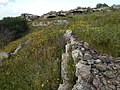
The Santoni are a collection of statues carved into a rock face near Palazzolo Acreide, the ancient Akrai, in Sicily.

<span class="mw-page-title-main">Capo Colonna</span>

Capo Colonna is a cape in Calabria located near Crotone. In ancient Roman times the promontory was called Promunturium Lacinium. The modern name derives from the remaining column of the Temple of Hera Lacinia.

<span class="mw-page-title-main">Roman shipyard of Stifone (Narni)</span> Archaeological site in Umbria, Italy

The Roman shipyard of Stifone is an archaeological find of Roman origin recently discovered in Umbria, in the municipality of Narni, inside an artificial channel adjacent the Nera River, about 900 metres down-river from the village of Stifone. Its position is just behind the remains of the river port of the ancient city of Narni.

<span class="mw-page-title-main">Akrai</span> Ancient Greek colony in Sicily

Akrai was a Greek colony of Magna Graecia founded in Sicily by the Syracusans in 663 BC. It was located near the modern Palazzolo Acreide.

<span class="mw-page-title-main">San Giovanni Fuoricivitas</span>

San Giovanni Fuoricivitas is a Romanesque religious church and adjacent buildings in Pistoia, Tuscany, central Italy. The adjective fuoricivitas refers to it location, outside of the first set of city walls, when it was founded during the era of Lombard rule in Italy.

<span class="mw-page-title-main">Greek Theatre of Syracuse</span> Theatre in the city of Syracuse in Sicily, Italy

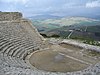
The Greek theatre of Syracuse lies on the south slopes of the Temenite hill, overlooking the modern city of Syracuse in southeastern Sicily, Italy. It was first built in the 5th century BC, rebuilt in the 3rd century BC and renovated again in the Roman period. Today, it is a part of the Unesco World Heritage Site of "Syracuse and the Rocky Necropolis of Pantalica".

<span class="mw-page-title-main">Angelo Italia</span>

Angelo Italia was an Italian Jesuit and Baroque architect, who was born in Licata and died in Palermo. He designed a number of churches in Sicily, and later worked to reconstruct three cities following the 1693 Sicily earthquake.

<span class="mw-page-title-main">Temple of Apollo (Syracuse)</span>

The Temple of Apollo is one of the most important ancient Greek monuments of Magna Graecia on Ortygia, in front of the Piazza Pancali in Syracuse, Sicily, Italy.

<span class="mw-page-title-main">Castra Albana</span>

The Castra Albana was an ancient Roman legionary fortress of the Legio II Parthica founded by the Emperor Septimius Severus (193-211) on the site of the present Albano Laziale.

<span class="mw-page-title-main">Grotta del Ninfeo</span>

<span class="mw-page-title-main">Castelluccio culture</span>

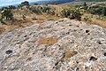
Castelluccio culture is an archaeological feature dating to Ancient Bronze Age of the prehistoric civilization of Sicily, originally identified by Paolo Orsi on the basis of a particular ceramic style, in the homonymous village, between Noto and Siracusa.

<span class="mw-page-title-main">Cathedral of Syracuse</span> UNESCO World Heritage Site

The Cathedral of Syracuse, formally the Cattedrale metropolitana della Natività di Maria Santissima, is an ancient Catholic church in Syracuse, Sicily, the seat of the Catholic Archdiocese of Siracusa. Its structure is originally a Greek doric temple, and for this reason it is included in a UNESCO World Heritage Site designated in 2005.

<span class="mw-page-title-main">Roman amphitheatre of Syracuse</span>

The Roman amphitheatre of Syracuse is one of the best preserved structures in the city of Syracuse, Sicily, from the early Imperial period.

<span class="mw-page-title-main">Amphitheatre of Catania</span>

The Amphitheatre of Catania is a Roman amphitheatre in Catania, Sicily, Southern Italy, built in the Roman Imperial period, probably in the 2nd century AD, on the northern edge of the ancient city at the base of the Montevergine hill. Only a small section of the structure is now visible, below ground level, to the north of Piazza Stesicoro. This area is now the historic centre of the city, but was then on the outskirts of the ancient town and also occupied by the necropolis of Catania. The structure is part of the Parco archeologico greco-romano di Catania.

<span class="mw-page-title-main">Florentia (Roman city)</span> Roman city

Florentia was a Roman city in the Arno valley from which Florence originated. According to tradition, it was built by the legions of Gaius Julius Caesar in 59 BC; however, the prevailing hypothesis dates the foundation of the city to the Augustan period.

References

  1. Francesca Gringeri Pantano (2003). Jean Hoüel: voyage a Siracusa : le antichità della città e del suo territorio nel 1777. Palermo: Sellerio.

Bibliography