Related Research Articles
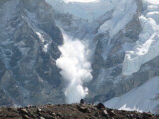
An avalanche is a rapid flow of snow down a slope, such as a hill or mountain.

Silverton is a statutory town that is the county seat, the most populous community, and the only incorporated municipality in San Juan County, Colorado, United States. The town is located in a remote part of the western San Juan Mountains, a range of the Rocky Mountains. The first mining claims were made in mountains above the Silverton in 1860, near the end of the Colorado Gold Rush and when the land was still controlled by the Utes. Silverton was established shortly after the Utes ceded the region in the 1873 Brunot Agreement, and the town boomed from silver mining until the Panic of 1893 led to a collapse of the silver market, and boomed again from gold mining until the recession caused by the Panic of 1907. The entire town is included as a federally designated National Historic Landmark District, the Silverton Historic District.

Rocky Mountain National Park is an American national park located approximately 55 mi (89 km) northwest of Denver in north-central Colorado, within the Front Range of the Rocky Mountains. The park is situated between the towns of Estes Park to the east and Grand Lake to the west. The eastern and western slopes of the Continental Divide run directly through the center of the park with the headwaters of the Colorado River located in the park's northwestern region. The main features of the park include mountains, alpine lakes and a wide variety of wildlife within various climates and environments, from wooded forests to mountain tundra.
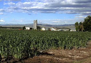
The Eastern Plains of Colorado refers to a region of the U.S. state of Colorado east of the Rocky Mountains and east of the population centers of the Front Range.

The Wallowa Mountains are a mountain range located in the Columbia Plateau of northeastern Oregon in the United States. The range runs approximately 40 miles (64 km) northwest to southeast in southwestern Wallowa County and eastern Union County between the Blue Mountains to the west and the Snake River to the east. The range is sometimes considered to be an eastern spur of the Blue Mountains, and it is known as the "Alps of Oregon". Much of the range is designated as the Eagle Cap Wilderness, part of the Wallowa–Whitman National Forest.

Ski touring is skiing in the backcountry on unmarked or unpatrolled areas. Touring is typically done off-piste and outside of ski resorts, and may extend over a period of more than one day. It is similar to backcountry skiing but excludes the use of a ski lift or transport.

The Bright Angel Trail is a hiking trail located in Grand Canyon National Park in the U.S. state of Arizona.
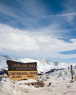
Loveland Pass is a high mountain pass in north-central Colorado, at an elevation of 11,990 feet (3,655 m) above sea level in the Rocky Mountains of the Western United States.

Berthoud Pass is a high mountain pass in central Colorado, in the Rocky Mountains of the western United States.

Cameron Pass is a mountain pass in north-central Colorado in the Rocky Mountains of the western United States. The pass is a gap between the south end of the Medicine Bow Mountains and the north end of the Never Summer Mountains. It sits on the border between Jackson County and Larimer County, approximately 3 mi north of the boundary of Rocky Mountain National Park. The pass provides the most convenient route between Fort Collins and Walden in North Park, using State Highway 14.

Alpental, named after the German word for alpine valley, is both a valley in eastern King County, Washington, United States and a ski area in the valley. The valley is about 50 miles (80 km) east of Seattle, Washington and is north of Snoqualmie Pass, in the Washington Cascades. It is a popular outdoor recreation destination in both the summer and winter. The ski area is one of four areas which make up The Summit at Snoqualmie.

The Porcupine Mountains, or Porkies, are a group of small mountains spanning the northwestern Upper Peninsula of Michigan in Ontonagon and Gogebic counties, near the shore of Lake Superior. The Porcupine Mountains were named by the native Ojibwa people, supposedly because their silhouette had the shape of a crouching porcupine. They are home to the most extensive stand of old growth northern hardwood forest in North America west of the Adirondack Mountains, spanning at least 31,000 acres (13,000 ha). The area is popular among tourists, especially Lake of the Clouds in the heart of the mountains, and is part of Porcupine Mountains Wilderness State Park.
In the United States, a backcountry or backwater is a geographical area that is remote, undeveloped, isolated, or difficult to access.

Quandary Peak is the highest summit of the Tenmile Range in the Rocky Mountains of North America and is the most commonly climbed fourteener in Colorado. It has nearly the same elevation as Castle Peak and Mount Evans. It lies in Summit County and within the White River National Forest about 6 miles (10 km) south-southwest of the town of Breckenridge.

A wilderness hut, bothy, backcountry hut, or backcountry shelter is a free, primitive mountain hut for temporary accommodation, usually located in wilderness areas, national parks and along backpacking and hiking routes. They are found in many parts of the world, such as Finland, Sweden, Norway, northern Russia, the Alps, the Pyrenees, Scotland, Australia, New Zealand, Canada, and the United States. Huts are basic and unmanned, without running water.

Backcountry snowboarding is snowboarding in a sparsely inhabited rural region over ungroomed and unmarked slopes or pistes in the backcountry, frequently amongst trees, usually in pursuit of fresh fallen snow, known as powder. Often, the land and the snow pack are not monitored, patrolled, or maintained. Fixed mechanical means of ascent such as ski lifts are typically not present, but alternative means such as splitboarding, hiking, snow shoeing and helicopters ("heliskiing") are sometimes used to reach the mountain's peak.

The Colorado Department of Transportation is the principal department of the Colorado state government that administers state government transportation responsibilities in the state of Colorado. CDOT is responsible for maintaining 9,144 mile highway system, including 3,429 bridges with over 28 billion vehicle miles of travel per year. CDOT's Mission is "To provide the best multi-modal transportation system for Colorado that most effectively moves people, goods, and information." It is governed by the Transportation Commission of Colorado.

Mount Rainier, also known as Tahoma, Tacoma, Tacobet, or təqʷubəʔ, is a large active stratovolcano in the Cascade Range of the Pacific Northwest, located in Mount Rainier National Park about 59 miles (95 km) south-southeast of Seattle. With a summit elevation of 14,411 ft (4,392 m), it is the highest mountain in the U.S. state of Washington and the Cascade Range, the most topographically prominent mountain in the contiguous United States, and the tallest in the Cascade Volcanic Arc.
The COVID-19 pandemic reached Colorado on March 5, 2020, when the state's first two cases were confirmed. Many of the early COVID-19 cases in Colorado occurred in mountain resort towns such as Crested Butte, Aspen, and Vail, apparently brought in, and sometimes taken home, by international ski tourists.
References
- 1 2 3 4 About the CAIC
- ↑ CAIC Staff
- ↑ Friends of CAIC
- ↑ FAQ Archived 2010-04-14 at the Wayback Machine