Colsterdale Light Railway

Last updated

Colsterdale Light Railway
Hunslet steam locomotive 'Leeds No 1'.jpg
A train on the CLR
Overview
StatusClosed
Locale Masham, North Yorkshire, England
Termini Masham railway station
History
Commenced1903 (1903)
Completed1905 (1905)
Technical
Line length6 mi (9.7 km)
Number of tracks1
Track gauge 2 ft (610 mm)

The Colsterdale Light Railway (CLR) was a narrow-gauge railway line in Colsterdale, North Yorkshire, England. It was built between 1903 and 1905 to allow materials to be taken up the Colsterdale valley for reservoir building. The building of two reservoirs (Roundhill, and later Leighton) in the valley of the River Burn, was first approved for the councils of Harrogate and Leeds respectively in 1901. Construction on the second reservoir was halted during the First World War, although the railway was kept in use carrying men and supplies to the training camp, later a PoW camp, at Breary Banks.

Contents

History

Initially, the Harrogate Corporation built a small railway yard near to what would become the site of Leighton Reservoir. This ran along up the valley to the site of their reservoir at Roundhill (some 1.75 miles (2.82 km) distant), and connected with the quarries on the high hillside of Colsterdale (on the southern flank). [1] [2] The yard at Leighton was a transhipment point from road to rail, but complaints about parking of steam traction engines in Masham town centre, and the "havoc wrought by traction engines [on the road between Masham and Leighton]", led to the development of the light railway connecting Masham railway station and the narrow gauge line at Leighton, engineered by Edward Wilson Dixon. [1] [3] Initially, the Leeds Corporation petitioned to build a standard-gauge railway, and the Harrogate Corporation wanted to stay with their 2-foot (0.61 m) gauge line. Both corporations submitted bills before Parliament, but Harrogate were successful, [note 1] after some negative press regarding why Leeds and Harrogate could not come to some understanding, and then, they had to negotiate with the North Eastern Railway about a connection with their terminus in Masham. [6] [7] The many river and stream crossings taken by the railway were on wooden trestle bridges, [8] but the bridge over the River Ure at Masham needed specific reinforcement against the heavy flow of the river. [9] Inward and outward bound traffic was swapped over in a yard to the north of Masham railway station, and from there, the line extended some 6 miles (9.7 km) up the valley. [10] [11]

Roundhill Reservoir was started and completed first by the Harrogate Corporation, whose aqueduct to carry water south into Nidderdale was also furnished with a 2 ft (610 mm) railway in the tunnel. [12] The Leeds company bought the rolling stock and line from Harrogate after the completion of Roundhill. Leeds initially intended to build one of their reservoirs in a side valley to the north of Roundhill at Spruce Gill Beck, [13] however, the geological conditions were found not to be unstable in that area, so a reformed plan involved building Leighton Reservoir first below the outfall of Roundhill, with a catchwater drain bringing water from Spruce Gill. [14] Before the location change, Leeds had already built the extension up to what was Breary Banks Camp, and although the reservoir would be in the adjacent valley, navvies were billeted at Breary Banks, which involved the Paddy Mail trains (workman's train) having to reverse at Leighton Junction. [15] The beginner for their project was Charles Henzell, who along with a consultant engineer, recommended that the reservoir at Spruce Gill (known as Colsterdale Reservoir on the plans) be abandoned. [16] During the 1910 Leighton reservoir building phase, the railway was carrying between 500 tonnes (550 tons) and 700 tonnes (770 tons) of goods per week. [17] Typical freight transhipped at Masham Exchange Yard included timber, coal and cement, with cement accounting for the heaviest traffic on the line. [18]

Leighton Junction - the curve in the middle is the former trackbed Colsterdale light railway trackbed at Leighton Junction - the curved ground in the middle is the former trackbed.jpg
Leighton Junction - the curve in the middle is the former trackbed

On 29 May 1911, one of the Harrogate engines was caught on the trestle of the bridge over a stream below the Leighton dam site. It derailed just before the bridge killing one of the footplate crew. [19] It was carrying several passengers, and despite the driver informing the manager that the load was too much (he reckoned about 20 tonnes (22 tons) behind a locomotive weighing 7 tonnes (7.7 tons)), the consist proceeded down the valley from Roundhill Dam, picking up speed on the 1-in-30 downhill section. The driver later attested that he could feel the weight of the train behind pushing his engine. [20]

In 1914, on the outbreak of the First World War, work on Leighton Reservoir slowed down as workers joined up to fight. The encampment at Breary Banks was commandeered by the army to house training for the Leeds Pals, and in 1915, work on the reservoir stopped completely, [21] although the railway was kept in use to bring supplies to the Breary Banks Camp for 1,000 men, and was also used to ferry soldiers to and from Masham railway station on occasion. [14] [22] Passenger workings consisted of Paddy Mail trains and occasional specials for the families of the workers on the reservoirs. [23] In 1917, the huts at Breary Banks were converted into a Prisoner of War camp. [11] [24]

Work on the reservoir resumed in 1919, and the reservoir was completed in 1926, with the rolling stock and tracks removed by 1932. [25] The passenger service along the former North Eastern Railway branch to Masham had also ceased in 1931. [26]

Notes

  1. This was approved as the Harrogate Waterworks Tramroad. [4] [5]

Related Research Articles

<span class="mw-page-title-main">Masham</span> Market town and civil parish in North Yorkshire, England

Masham is a market town and civil parish in the Harrogate district of North Yorkshire, England. It had a population of 1,205 at the 2011 census.

<span class="mw-page-title-main">Yorkshire Water</span> Water supply and treatment utility company in England

Yorkshire Water is a water supply and treatment utility company servicing West Yorkshire, South Yorkshire, the East Riding of Yorkshire, part of North Lincolnshire, most of North Yorkshire and part of Derbyshire, in England. The company has its origins in the Yorkshire Water Authority, one of ten regional water authorities created by the Water Act 1973, and privatised under the terms of the Water Act 1989, when Yorkshire Water plc, the parent company of the Yorkshire Water business, was floated on the London Stock Exchange. The parent company was Kelda Group in 1999. In February 2008, Kelda Group was bought by a consortium of infrastructure funds.

<span class="mw-page-title-main">Roundhill Reservoir</span> Reservoir in North Yorkshire, England

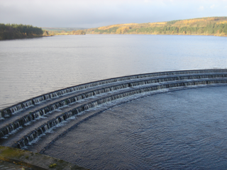
Roundhill Reservoir is situated near Leighton Reservoir in North Yorkshire, England. It was constructed by Harrogate Corporation early in the 20th century. Water from the reservoir is fed into Yorkshire Water's grid.

<span class="mw-page-title-main">Stocks Reservoir</span> Reservoir in Lancashire, England

Stocks Reservoir is a reservoir situated at the head of the Hodder valley in the Forest of Bowland, Lancashire, England. It provides water mainly for Blackpool and the Fylde coast. The reservoir has a fly fishing club which is very popular in the summer months and a small cafe which is popular with walkers. The Board House is a building used for meetings by United Utilities and is located on the western shores of the reservoir, near the Hodder Water Treatment Works. Stocks Reservoir was opened on 5 July 1932 by Prince George, K.G.

<span class="mw-page-title-main">Healey, North Yorkshire</span> Village and civil parish in North Yorkshire, England

Healey is a small village and civil parish in the Harrogate district of North Yorkshire, England. It is situated in the valley of the River Burn, to the immediate west of Fearby. It is about three miles west of Masham in the Nidderdale Area of Outstanding Natural Beauty. There are several holiday cottages and four Grade II Listed buildings, one of which is Healey Mill, a former corn mill.

<span class="mw-page-title-main">Fewston Reservoir</span> Reservoir in North Yorkshire, England

Fewston Reservoir is located in the Washburn valley north of Otley and west of Harrogate in Yorkshire, England. It was built in 1879. The capacity is about 3.5 million cubic metres. It can be found from the A59 road. The overflow from the reservoir feeds directly into the adjoining Swinsty Reservoir. Formerly, this overflow was encircled by a metal walkway from which floodboards could be lowered, but this has since been removed. The reservoir is the property of Yorkshire Water, which manages it for the benefit of walkers, anglers and wildlife. Situated in the charming Washburn valley, sharing an embankment with Swinsty Reservoir, Fewston is popular with walkers and runners. Cyclists and horse-riders can also make use of their own permitted tracks in the surrounding woodlands.

<span class="mw-page-title-main">Swinsty Reservoir</span> Reservoir in North Yorkshire, England

Swinsty Reservoir is a reservoir in the Washburn valley north of Otley and west of Harrogate in Yorkshire, England. Construction began in 1871 and was completed in 1878. The capacity is about 866 million gallons, with a surface area of 63 hectares. It can be found from the A59 road.

<span class="mw-page-title-main">Colsterdale towers</span>

The Colsterdale towers are a set of sighting towers in and around Colsterdale, North Yorkshire, England.

<span class="mw-page-title-main">Colsterdale</span> Valley in North Yorkshire, England

Colsterdale is the valley of the River Burn, a tributary of the River Ure, in the Yorkshire Dales in North Yorkshire, England. It gives its name to a hamlet and civil parish in the upper part of the dale, about 7 miles (11 km) west of Masham. The population of the civil parish was estimated at 20 in 2010. The lower part of the dale around the hamlet of Gollinglith Foot is in the civil parish of Healey. The area is in Harrogate district.

<span class="mw-page-title-main">Thomas Green & Son</span>

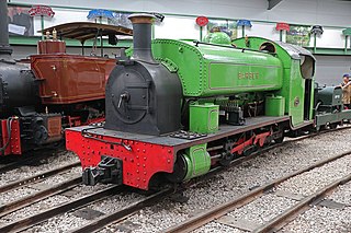
Thomas Green & Son, Ltd. were engineers who manufactured a wide range of products at the Smithfield Foundry, Leeds, United Kingdom

<span class="mw-page-title-main">Leighton Reservoir</span> Reservoir in North Yorkshire, England

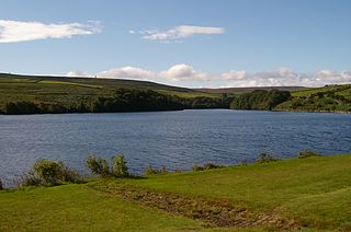
Leighton Reservoir is a reservoir which drains via the River Burn to the River Ure in North Yorkshire, England. It neighbours Roundhill Reservoir and is about 4 miles (6.4 km) west of Masham. It takes its name from the nearby village of Leighton.

<span class="mw-page-title-main">Nidd Valley Light Railway</span> Disused railway in Yorkshire, England

Nidd Valley Light Railway was a light railway in upper Nidderdale in the West Riding of Yorkshire, England. It was owned by Bradford Corporation Waterworks Department and the corporation also operated its public passenger services. Power & Traction Ltd of London obtained a Light Railway Order for the 6.5-mile (10.5 km) railway from Pateley Bridge to Lofthouse in 1900, but these powers were taken over by Bradford Corporation. A contract to build Angram Reservoir was awarded to John Best & Son in 1903, and he also won the contract to build the public railway and a 6.5-mile (10.5 km) private extension to the reservoir site. This was initially built to 3 ft gauge but was converted to standard gauge by 1907, when the public railway opened. Best had his own locomotives, and Bradford Corporation equipped the public railway with second hand locomotives and carriages from the Metropolitan Railway.

<span class="mw-page-title-main">Masham branch</span>

The Masham branch was a 7+34-mile (12.5 km) long North Eastern Railway built single track branch railway line that ran between a junction on the Harrogate to Northallerton line at Melmerby to Masham, North Yorkshire, via one intermediate station, Tanfield.

<span class="mw-page-title-main">River Burn, North Yorkshire</span> River in North Yorkshire, England

The River Burn is a river that flows wholly within North Yorkshire, England. The river starts as several small streams on Masham Moor and drains Colsterdale flowing eastwards before emptying into the River Ure just south of Masham. Conservation work on removing a weir, and introducing fish to the river in 2016, has meant that salmon have been recorded spawning in the river for the first time in over 100 years.

<span class="mw-page-title-main">Masham railway station</span> Disused railway station in North Yorkshire, England

Masham railway station was the terminus of the Melmerby to Masham branch line serving the town of Masham in North Yorkshire, England. It was on the eastern side of the River Ure, so as such, was actually in Burton-on-Ure. The line operated between 1875 and 1931 for passenger traffic, but was retained for minimal freight train use until 1963.

Wath-in-Nidderdale railway station, was one of two intermediate stations on the Nidd Valley Light Railway, in Wath-in-Nidderdale, Yorkshire, England. The station was opened in September 1907, and closed to passengers in January 1930, however the line remained open until 1936 to transport freight to and from the reservoirs in the Upper Nidd Valley.

<span class="mw-page-title-main">Upper Barden Reservoir</span> Freshwater reservoir in North Yorkshire, England

Upper Barden Reservoir is an upland fresh water reservoir, one of two reservoirs that collect water from Barden Moor, and dam Barden Beck, a tributary of the River Wharfe in the Yorkshire Dales, North Yorkshire, England. The reservoir was opened in 1882 and also supplies fresh water to the Nidd Aqueduct, which transports it to Bradford. Upper Barden Reservoir was the second of the reservoirs to be built,.

Lofthouse-in-Nidderdale railway station was the northernmost regular passenger terminus on the Nidd Valley Light Railway (NVLR), in Lofthouse, then in the West Riding of Yorkshire and now in North Yorkshire, England. The station was built as part of Bradford Corporation's programme of reservoir building in the Upper Nidd Valley. The station opened in 1904 and was closed to passengers in 1930. The station was renamed Lofthouse-in-Nidderdale railway station in 1907 to avoid confusion with Lofthouse and Outwood railway station, also in the West Riding of Yorkshire.

Pateley Bridge railway station (NVLR) was a railway station serving the southern terminus of the Nidd Valley Light Railway, in Pateley Bridge, North Yorkshire, England. The railway was built to enable the construction of reservoirs in the Upper Nidd Valley by the Bradford Corporation. The station opened to passengers in September 1907, and closed in January 1930, however, the adjacent line remained open for the transfer of goods traffic until 1937.

<span class="mw-page-title-main">Harrogate Gasworks Railway</span> Former industrial railway in Yorkshire, England

Harrogate Gasworks Railway was an industrial railway in the town of Harrogate, North Yorkshire, England. The line was a narrow gauge railway that ran between Bilton Junction on the Leeds and Thirsk Railway, to the Harrogate Gas Company's (HGC) works at New Park, north of the town centre. It opened in 1908 to carry inbound coal for gasification, and was closed to traffic in 1956. The railway was noted for its tight gauge restrictions in the tunnel through New Park. Two of its steam locomotives have survived into preservation, and are still in use on heritage railways.

References

  1. 1 2 Bowtell 1991, p. 17.
  2. Household 1995, p. 137.
  3. Bright, Thomas (28 May 2021). "Raising the Roof". Steam Railway. No. 519. Peterborough: Bauer Media. p. 9. ISSN   0143-7232.
  4. "Acts of the Parliaments of the United Kingdom Part 127 (1904b)". legislation.gov.uk. Retrieved 24 November 2022.
  5. Household 1995, p. 138.
  6. Roelich, Katy; Stark, James; Owen, Alice (9 January 2020). "The reservoirs that weren't: lessons for contemporary infrastructure planning". historyandpolicy.org. Retrieved 23 February 2023.
  7. Bowtell 1991, pp. 16–18.
  8. "WW1 Heritage Trail, Colsterdale, near Masham" (PDF). nidderdaleaonb.org.uk. Retrieved 24 November 2022.
  9. Household 1995, pp. 139–140.
  10. Hoole, K. (1973). North-East England. Newton Abbot: David and Charles. p. 90. ISBN   0715358944.
  11. 1 2 "Disused Stations: Masham Station". disused-stations.org.uk. Retrieved 8 March 2023.
  12. Bayliss, Derek; Cant, David (Spring 2008). "Regional News: Yorkshire". Industrial Archaeology News. Telford: Association for Industrial Archaeology (144): 16. ISSN   1354-1455. OCLC   31192069.
  13. Cunliffe-Lister, Susan (1999) [1989]. Days of Yore - a History of Masham. York: Wilton 65. p. 170. ISBN   0-947828-72-9.
  14. 1 2 Cunliffe-Lister, Susan (1999) [1989]. Days of Yore - a History of Masham. York: Wilton 65. p. 171. ISBN   0-947828-72-9.
  15. Household 1995, pp. 140–141.
  16. "1906 Leeds Corporation Waterworks". discovery.nationalarchives.gov.uk. Retrieved 25 February 2023.
  17. "Leeds Water Supply". The Times. No. 39407. 19 October 1910. p. 13. ISSN   0140-0460.
  18. Bowtell 1991, p. 21.
  19. "Engine Falls Over - Workman Killed in Light Railway Accident". The Leeds Mercury. 31 May 1911. p. 3. OCLC   11968069.
  20. Bowtell 1991, p. 31.
  21. Household 1995, p. 142.
  22. Milner, Laurie (1991). Leeds Pals : a history of the 15th (Service) Battalion (1st Leeds), the Prince of Wales's Own (West Yorkshire Regiment) 1914-1918. London: L. Cooper. p. 30. ISBN   0850523354.
  23. Redman, R. N. (Summer 1987). "A Contractor's Excursion". The Narrow Gauge. No. 115. The Narrow Gauge Railway Society. p. 14. ISSN   0142-5587.
  24. Roberts, Alan (13 January 2023). "Raikeswood POW Camp and the 1919 national railway strike". Craven Herald. Retrieved 8 March 2023.
  25. Household 1995, p. 143.
  26. Joy, David (2017). Rails in the Dales : eight Yorkshire railways. Mold: Railway & Canal Historical Society. p. 74. ISBN   978-0-901461-65-0.

Sources

Coordinates: 54°13′05″N1°42′36″W / 54.218°N 1.710°W / 54.218; -1.710