Related Research Articles

Cumberland County is a coastal county located on the Delaware Bay in the Southern Shore Region of the U.S. state of New Jersey. As of the 2020 census, the county was the state's 16th-most-populous county, with a population of 154,152, a decrease of 2,746 (−1.8%) from the 2010 census count of 156,898. Its county seat is Bridgeton. Cumberland County is named for Prince William, Duke of Cumberland. The county was formally created from portions of Salem County on January 19, 1748.

Route 49 is a state highway in the southern part of the U.S. state of New Jersey. It runs 53.80 mi (86.58 km) from an interchange with the New Jersey Turnpike, Interstate 295 (I-295), and U.S. Route 40 (US 40) in Deepwater, Salem County, southeast to Route 50 and County Route 557 in Tuckahoe, Cape May County. The route serves Salem, Cumberland, Atlantic, and Cape May counties, passing through rural areas and the communities of Salem, Bridgeton, and Millville along the way. It is a two-lane, undivided road for most of its length.
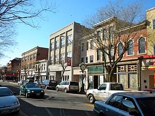
Bridgeton is a city in Cumberland County, within the U.S. state of New Jersey. It is the county seat of Cumberland County and is located on the Cohansey River near Delaware Bay in the South Jersey region of the state.

Deerfield Township is a township in Cumberland County, in the U.S. state of New Jersey. It is part of the Vineland--Bridgeton metropolitan statistical area, which encompasses those cities and all of Cumberland County for statistical purposes and which constitutes a part of the Delaware Valley. As of the 2020 United States census, the township's population was 3,136, an increase of 17 (+0.5%) from the 2010 census count of 3,119, which in turn reflected an increase of 192 (+6.6%) from the 2,927 counted in the 2000 census.
Downe Township is a township in Cumberland County, in the U.S. state of New Jersey. It is part of the Vineland-Bridgeton metropolitan statistical area for statistical purposes. As of the 2020 United States census, the township's population was 1,399, a decrease of 186 (−11.7%) from the 2010 census count of 1,585, which in turn reflected decline of 46 (−2.8%) from the 1,631 counted in the 2000 census.

Fairfield Township is a township in Cumberland County, in the U.S. state of New Jersey. It is part of the Vineland-Bridgeton metropolitan statistical area, which encompasses all of Cumberland County for statistical purposes and which constitutes a part of the Delaware Valley. As of the 2020 United States census, the township's population was 5,546, a decrease of 749 (−11.9%) from the 2010 census count of 6,295, which in turn reflected an increase of 12 (+0.2%) from the 6,283 counted in the 2000 census.

Greenwich Township is the westernmost township in Cumberland County, in the U.S. state of New Jersey. As of the 2020 United States census, the township's population was 771, a decrease of 33 (−4.1%) from the 2010 census count of 804, which in turn reflected a decline of 43 (−5.1%) from the 847 counted in the 2000 census. It is part of the Vineland-Bridgeton metropolitan statistical area, which encompasses those cities and all of Cumberland County for statistical purposes and which constitutes a part of the Delaware Valley.

Hopewell Township is a township in Cumberland County, in the U.S. state of New Jersey. It is part of the Vineland-Bridgeton metropolitan statistical area, which encompasses those cities and all of Cumberland County for statistical purposes and which constitutes a part of the Delaware Valley. As of the 2020 United States census, the township's population was 4,391, a decrease of 180 (−3.9%) from the 2010 census count of 4,571, which in turn reflected an increase of 137 (+3.1%) from the 4,434 counted in the 2000 census.

Shiloh is a borough in Cumberland County, in the U.S. state of New Jersey. It is part of the Vineland–Bridgeton metropolitan statistical area for statistical purposes. As of the 2020 United States census, the borough's population was 444, a decrease of 72 (−14.0%) from the 2010 census count of 516, which in turn reflected a decline of 18 (−3.4%) from the 534 counted in the 2000 census.

Stow Creek Township is a township in Cumberland County, in the U.S. state of New Jersey. It is part of the Vineland-Bridgeton metropolitan statistical area for statistical purposes. As of the 2020 United States census, the township's population was 1,312, a decrease of 119 (−8.3%) from the 2010 census count of 1,431, which in turn reflected an increase of two people (+0.1%) from the 1,429 counted in the 2000 census.
Upper Deerfield Township is a township in Cumberland County, in the U.S. state of New Jersey. It is part of the Vineland-Bridgeton metropolitan statistical area, which encompasses those cities and all of Cumberland County for statistical purposes and which constitutes a part of the Delaware Valley. As of the 2020 United States census, the township's population was 7,645, a decrease of 15 (−0.2%) from the 2010 census count of 7,660, which in turn reflected an increase of 104 (+1.4%) from the 7,556 counted in the 2000 census.

Route 77 is a state highway in the southern part of the U.S. state of New Jersey. It runs 22.55 mi (36.29 km) from an intersection with Route 49 in Bridgeton in Cumberland County north to a junction with Route 45 in Mullica Hill in Gloucester County. It is a mostly two-lane, undivided road traversing through farmland in Cumberland, Salem, and Gloucester Counties. Along the way, Route 77 intersects Route 56 in Upper Deerfield Township and U.S. Route 40 in Upper Pittsgrove Township.
Three agreements, each known as a Treaty of Hopewell, were signed between representatives of the Congress of the United States and the Cherokee, Choctaw, and Chickasaw peoples. They were negotiated and signed at the Hopewell plantation in South Carolina over 45 days during the winter of 1785–86.
Bergen Township was a township that existed in Bergen County, New Jersey. The township was created on February 21, 1893, from the southern section of Lodi Township :
Be It Enacted by the Senate and General Assembly of Portion to be the State of New Jersey, That all that portion of the township of Lodi, in the county of Bergen, lying within the following boundaries, to wit, beginning at the intersection Boundaries, of the northerly boundary of the township of Boiling Springs, in the county of Bergen, with the middle of the Passaic river; running thence easterly along the northerly boundary of said township of Boiling Springs to the middle of the Hackensack River; thence, northerly along the middle of the Hackensack river to a point opposite the mouth of a creek emptying into said river, commonly known as the Upper Mudabock creek; thence, westerly in a straight line to a point where the northerly line of the public road leading from Moonachie to Wood-Ridge, commonly known as the Mousetown road, intersects the westerly line of the public road commonly known as the Moonachie road; thence, westerly along the northerly line of the Mousetown road to the westerly line of the Riser ditch; thence, northerly along the westerly line of said ditch to the northerly line of lands now or formerly belonging to the estate of Richard Vreeland; thence, westerly along said line of lands to the Polifly road; thence, still westerly in the same course as last described, along the northerly line of lands now or formerly belonging to the estate of Benjamin Cox to a line commonly known as the Polifly line; thence, northerly along said line to the southerly line of the public road leading from said Polifly road to the public road commonly known as the River road; thence westerly along the southerly line of said road leading from the Polifly road to the River road; thence, still westerly in line with the last course of the southerly line of said road to the middle of the Saddle river; thence, downstream through the middle of the Saddle river to the middle of the Passaic thence, down stream through the middle of said to the place of beginning, shall be and hereby is set off from the township Lodi, in the county of Bergen, and made a separate township, to be known by the name of the township of Bergen.
Cohansey Township was a township that existed in Cumberland County, New Jersey, United States, during two separate periods, from 1697 to 1748 and from 1848 to 1865. The name was derived from the Cohansey River, which flows through the area.
Bergen was a city that existed in Hudson County, New Jersey, United States, from 1855 to 1870.
Roadstown is an unincorporated community located within Stow Creek Township, in Cumberland County, in the U.S. state of New Jersey.
Musconetcong County was a proposed county in New Jersey, which was to be created from parts of Hunterdon and Warren counties.
Sheppards Mill is an unincorporated community and census-designated place (CDP) in Cumberland County, in the U.S. state of New Jersey. It is located in the western part of the county in northeastern Greenwich Township and southwestern Hopewell Township. The community is centered on Mill Creek, which is dammed to form Sheppards Millpond in the northwestern part of the CDP. Mill Creek is a southwest-flowing tributary of Wheaton Run, part of the Cohansey River watershed leading to Delaware Bay.
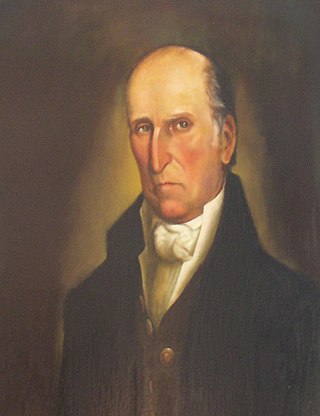
Bloomfield Holmes Minch was an American businessman and politician from New Jersey.
References
- ↑ Acts of the Legislature of the State of New Jersey. Publisher Secretary of State., 1842. Page 93.
- ↑ Jersey, New (1842). Acts of the Legislature of the State of New Jersey. Secretary of State of New Jersey. p. 194 . Retrieved 2011-02-11.
An Act to establish a new township in the county at Cumberland.
- ↑ "The Story of New Jersey's Civil Boundaries: 1606-1968", John P. Snyder, Bureau of Geology and Topography; Trenton, New Jersey; 1969. p. 119.