Clarion Municipal Airport is a city-owned public-use airport located one nautical mile (1.85 km) northwest of the central business district of Clarion, a city in Wright County, Iowa, United States. This airport is included in the FAA's National Plan of Integrated Airport Systems for 2009–2013, which categorized it as a general aviation facility.
Springdale Municipal Airport is a public use airport in Washington County, Arkansas, United States. It is owned by the City of Springdale and located one nautical mile (2 km) southeast of its central business district. This airport is included in the National Plan of Integrated Airport Systems for 2011–2015, which categorized it as a general aviation facility.

Zanesville Municipal Airport is a city-owned airport six miles east of downtown Zanesville, in Muskingum County, Ohio. The National Plan of Integrated Airport Systems for 2011–2015 called it a general aviation facility.
Columbus County Municipal Airport is a county-owned, public-use airport in Columbus County, North Carolina, United States. It is located three nautical miles (6 km) south of the central business district of Whiteville, North Carolina. This airport is included in the National Plan of Integrated Airport Systems for 2011–2015, which categorized it as a general aviation facility.
Elkhart Municipal Airport is a city-owned public-use airport located three nautical miles (6 km) northwest of the central business district of Elkhart, a city in Elkhart County, Indiana, United States.
Warsaw Municipal Airport is a public use airport located two miles (3 km) north of the central business district of Warsaw, a city in Kosciusko County, Indiana, United States. It is owned by the Warsaw Board of Aviation Commissioners.
During World War II, the United States Army Air Forces (USAAF) established numerous airfields in Indiana for training pilots and aircrews of USAAF fighters and bombers.

Cleveland Municipal Airport is a public use airport in Bolivar County, Mississippi, United States. It is owned by the City of Cleveland and located two nautical miles (4 km) northwest of its central business district. This airport is included in the National Plan of Integrated Airport Systems for 2011–2015, which categorized it as a general aviation facility. There is no scheduled commercial airline service.
Virgil I. Grissom Municipal Airport is a public use airport located three nautical miles southeast of the central business district of Bedford, a city in Lawrence County, Indiana, United States.
Shelbyville Municipal Airport is a public use airport located four nautical miles (7 km) northwest of the central business district of Shelbyville, in Shelby County, Indiana, United States. The airport is owned by the city of Shelbyville and is controlled by the mayor and an appointed Board of Commissioners. According to the FAA's National Plan of Integrated Airport Systems for 2009–2013, it was classified as a general aviation airport.
Huntington Municipal Airport is a city-owned, public-use airport located three nautical miles southeast of the central business district of Huntington, a city in Huntington County, Indiana, United States. According to the FAA's National Plan of Integrated Airport Systems for 2009–2013, it was classified as a general aviation airport.
Orange City Municipal Airport was a city-owned public-use airport located one nautical mile (1.85 km) south of the central business district of Orange City, a city in Sioux County, Iowa, United States. This airport was included in the FAA's National Plan of Integrated Airport Systems for 2009–2013, which categorized it as a general aviation facility.

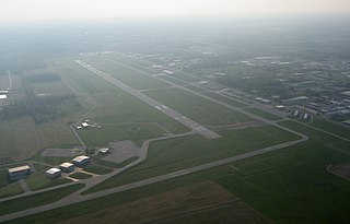
Kokomo Municipal Airport is five miles northeast of Kokomo, in Howard County, Indiana. It is owned by the Kokomo Board of Aviation Commissioners. The FAA's National Plan of Integrated Airport Systems for 2009–2013 categorized it as a general aviation facility.
Baker Municipal Airport is a public-use airport located one nautical mile southeast of the central business district of Baker, a city in Fallon County, Montana, United States. The airport is owned by Baker City and Fallon County. It is included in the FAA's National Plan of Integrated Airport Systems for 2011–2015, which categorized it as a general aviation facility.
Marion Municipal Airport is located three miles southwest of Marion, in Grant County, Indiana. The FAA's National Plan of Integrated Airport Systems for 2021–2025 categorized it as a general aviation facility.
Richmond Municipal Airport is six miles southeast of Richmond near Boston, in Wayne County, Indiana. It is owned by the Richmond Board of Aviation Commissioners. The National Plan of Integrated Airport Systems for 2011–2015 called it a general aviation facility.
York Municipal Airport is a mile northwest of York, in York County, Nebraska. The National Plan of Integrated Airport Systems for 2011–2015 categorized it as a general aviation facility.
Portland Municipal Airport is a city-owned, public-use airport located one nautical mile (2 km) northwest of the central business district of Portland, a city in Jay County, Indiana, United States. It is included in the National Plan of Integrated Airport Systems for 2011–2015, which categorized it as a general aviation facility.
New Castle-Henry County Municipal Airport is a public use airport located four nautical miles southeast of the central business district of New Castle, a city in Henry County, Indiana, United States. It is included in the National Plan of Integrated Airport Systems for 2011–2015, which categorized it as a general aviation facility.
Kentland Municipal Airport is a public use airport located one nautical mile (2 km) southeast of the central business district of Kentland, in Newton County, Indiana, United States. It is owned by the Kentland Board of Aviation Commissioners. This airport was included in the National Plan of Integrated Airport Systems for 2011–2015, which categorized it as a general aviation facility.


