Limehouse is a district in the London Borough of Tower Hamlets in East London. It is 3.9 miles (6.3 km) east of Charing Cross, on the northern bank of the River Thames. Its proximity to the river has given it a strong maritime character, which it retains through its riverside public houses and steps, such as The Grapes and Limehouse Stairs. It is part of the traditional county of Middlesex. It became part of the ceremonial County of London following the passing of the Local Government Act 1888, and then part of Greater London in 1965.

The London Borough of Tower Hamlets is a borough of London, England. Situated on the north bank of the River Thames and immediately east of the City of London, the borough spans much of the traditional East End of London and includes much of the regenerated London Docklands area. The 2019 mid-year population for the borough is estimated at 324,745.

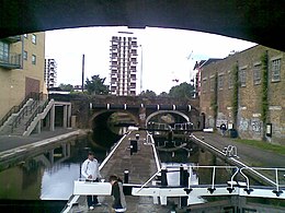
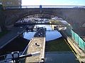
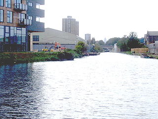
The Limehouse Cut is a largely straight, broad canal in the East End of London which links the lower reaches of the Lee Navigation to the River Thames. Opening on 17 September 1770, and widened for two-way traffic by 1777, it is the oldest canal in the London area. Although short, it has a diverse social and industrial history. Formerly discharging directly into the Thames, since 1968 it has done so indirectly by a connection through Limehouse Basin.

Limehouse Basin is a body of water 2 miles east of London Bridge that is also a navigable link between the River Thames and two of London's canals. First dug in 1820 as the eastern terminus of the new Regent's Canal, its wet area was less than 5 acres originally, but it was gradually enlarged in the Victorian era, reaching a maximum of double that size, when it was given its characteristic oblique entrance lock, big enough to admit 2,000-ton ships.

Regent's Canal is a canal across an area just north of central London, England. It provides a link from the Paddington Arm of the Grand Union Canal, 550 yards (500 m) north-west of Paddington Basin in the west, to the Limehouse Basin and the River Thames in east London. The canal is 8.6 miles (13.8 km) long.
The Hertford Union Canal or Duckett's Cut, just over 1 mile (1.6 km) long, connects the Regent's Canal to the Lee Navigation in the London Borough of Tower Hamlets in East London. It was opened in 1830 but quickly proved to be a commercial failure. It was acquired by the Regents Canal Company in 1857, and became part of the Grand Union Canal in 1927.
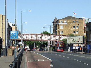
Commercial Road is a street in the London Borough of Tower Hamlets in the East End of London. It is 1.9 miles (3.1 km) long, running from Gardiner's Corner, through Stepney to the junction with Burdett Road in Limehouse at which point the route splits into the East India Dock Road and the West India Dock Road. It is an artery connecting the historic City of London with the more recently developed financial district at Canary Wharf, and part of the A13.

Mile End Stadium, also known as the East London Stadium, is a multi-sports stadium in Mile End and situated in the park of the same name, east London, England. The stadium comprises an athletics stadium and a number of floodlit Astroturf football pitches, tennis and netball courts.

The London Borough of Tower Hamlets, in spite of being close to the centre of London and perhaps retaining the idea of it being the docklands area, has over 100 areas of parks and open spaces within its boundaries. These range from the huge to small gardens and squares. In common with all the London boroughs, these green spaces provide "lungs" for the leisure pursuits of the inhabitants.

The London Borough of Hackney, one of the inner London boroughs, has 62 parks, gardens and open spaces within its boundaries, totalling 330 ha. These provide the "green lungs" for leisure activities. Hackney Marshes contain the largest concentration of football pitches in Europe.

Bromley Stop Lock was a lock on the Limehouse Cut in the London Borough of Tower Hamlets that was situated near the junction of Limehouse Cut and the River Lee Navigation by Bow Locks.
Britannia Stop Lock was a lock on the Limehouse Cut in the London Borough of Tower Hamlets. It was built in 1853. The gates were either side of Commercial Road bridge and were oriented such that a boat travelling from south-west to north-east would ascend in height.

St Pancras Lock is a lock on the Regent's Canal, in the London Borough of Camden, England. The St Pancras Basin is nearby.

City Road Lock is a lock on the Regent's Canal, in the London Borough of Islington, England. It is located a short distance to the east of Islington Tunnel, and immediately to the west of City Road Basin.

Old Ford Lock is a lock on the Regent's Canal, between Globe Town and Old Ford in the London Borough of Tower Hamlets.

Limehouse Basin Lock is a lock forming the exit from Limehouse Basin to the Thames, in the London Borough of Tower Hamlets, England. It is the final lock on the Regent's Canal. The Narrow Street swing bridge sits between the lock and the river.

The Angel is an area on the northern fringes of Central London within the London Borough of Islington. It is 2 miles (3.2 km) north-northeast of Charing Cross on the Inner Ring Road at a busy transport intersection. The area is identified in the London Plan as one of 35 major centres in London. It is a significant commercial and retail centre, and a business improvement district. The Angel straddles the ancient boundary of the parishes of Clerkenwell and Islington that later became the metropolitan boroughs of Finsbury and Islington. It is named from the former Angel Inn which stood on the corner of Islington High Street and Pentonville Road. Since 1965 the whole area has formed part of the London Borough of Islington in Greater London.

Salmon Lane Lock is a lock on the Regent's Canal, in Limehouse in the London Borough of Tower Hamlets. A new footbridge at the lock was completed in February 2005 connecting Parnham Street to Salmon Lane.

The Paddington Canal or Paddington Arm of the Grand Union Canal is a 13+1⁄2-mile (22 km) canal to Paddington in central London, England. It runs from the west of the capital at Bull's Bridge in Hayes. Little Venice — its only junction — is with the Regent's Canal, London that runs to Limehouse Basin to the east. The arm and the two canals it links are fed by water by the Brent Reservoir. The Paddington Arm is part of a long pound that stretches for nearly thirty miles.