
The Blackstone Valley or Blackstone River Valley is a region of Massachusetts and Rhode Island. It was a major factor in the American Industrial Revolution. It makes up part of the Blackstone River Valley National Heritage Corridor and National Historical Park.

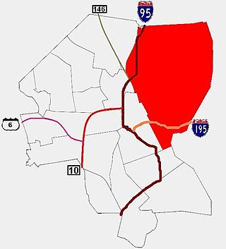
The Blackstone Canal was a manmade waterway, linking Worcester, Massachusetts, to Providence, Rhode Island, and Narragansett Bay, through the Blackstone Valley, via a series of locks and canals in the early 19th century. Construction started in 1825, and the canal opened three years later. After the opening of the Boston and Providence Railroad (1835), the canal struggled for business. Its transportation role was taken over by the Providence and Worcester Railroad, which completed a parallel line in 1847. The canal shut down in 1848. Several segments of the canal are preserved, and the canal alignment and remains are on the National Register of Historic Places.

William Blaxton was an early English settler in New England and the first European settler of Boston and Rhode Island.

The Slater Mill is a historic water-powered textile mill complex on the banks of the Blackstone River in Pawtucket, Rhode Island, modeled after cotton spinning mills first established in England. It is the first water-powered cotton spinning mill in America to utilize the Arkwright system of cotton spinning as developed by Richard Arkwright.

The Roger Williams National Memorial is a landscaped urban park located on a common lot of the original settlement of Providence, Rhode Island, established by minister Roger Williams in 1636. The national memorial commemorates the life of Williams, who co-founded the Colony of Rhode Island and Providence Plantations and championed religious freedom. The park is bounded by North Main, Canal, and Smith Streets, and Park Row.

Blackstone is a predominantly residential neighborhood in Providence, Rhode Island. It is in the northeast corner of the city and is bounded to the south and west by Lloyd Avenue and Hope Street respectively. It is one of six neighborhoods comprising the East Side of Providence.
The East Side is a collection of neighborhoods in the eastern part of the city of Providence, Rhode Island. It officially comprises the neighborhoods of Blackstone, Hope, Mount Hope, College Hill, Wayland, and Fox Point.
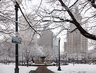
Burnside Park is a small park situated in Downtown Providence, Rhode Island, adjacent to Kennedy Plaza. The park is named for Ambrose Burnside, a general in the American Civil War from Rhode Island. An equestrian statue of Ambrose Burnside was erected in the late 19th century and sits in the center of the park.

This is a list of the National Register of Historic Places listings in Providence, Rhode Island.

The World War I Memorial is a bronze sculpture by Pietro Montana and is located at the intersection of Taunton Avenue, Whelden Avenue, and John Street in East Providence, Rhode Island, United States. The sculpture is modeled on Charles Atlas and depicts a dynamically posed soldier standing on a granite base. Montana's original design was modified by the East Providence Memorial Committee for being "too brutal". Dedicated on July 30, 1927, Major General Charles Pelot Summerall gave an address which highlighted the handicap placed upon the soldiers by a lack of preparedness and "invoked the fighting ideal embodied by Montana's doughboy." The World War I Memorial was added to the National Register of Historic Places in 2001.
The Blackstone Boulevard Realty Plat Historic District is a historic district roughly bounded by Blackstone Blvd., Rochambeau Ave., Holly St. and Elmgrove Ave. in Providence, Rhode Island.

Blackstone Park Historic District is roughly bounded by the Seekonk River, Laurell Avenue, Blackstone Boulevard, and South Angell Street in Providence, Rhode Island within the Blackstone neighborhood of the East Side.

Butler Hospital is a private, non-profit, psychiatric and substance abuse hospital for adolescents, adults, and seniors, located at 345 Blackstone Boulevard in Providence, Rhode Island. The hospital is affiliated with the Warren Alpert Medical School of Brown University, and is the flagship for Brown University's renowned department of psychiatry. Butler Hospital was a founding member, along with Women & Infants Hospital and Kent Hospital, of the Care New England health system in 1996.
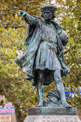
Columbus is a historic statue in Johnston, Rhode Island. The statue is a bronze cast of a sterling silver statue which was created by Rhode Island's Gorham Manufacturing Company for the 1892 World's Columbian Exposition in Chicago. The original silver statue was not meant for permanent exhibition, but rather as a demonstration of the skills of the Gorham Company, and was later melted down. The bronze cast was dedicated on November 8, 1893, in Columbus Square, in Providence, Rhode Island, United States as a gift from the Elmwood Association to the City of Providence.

The Elmwood Historic District encompasses two large residential sections of the Elmwood neighborhood of Providence, Rhode Island. The Elmwood area was mainly farmland until the mid-19th century, when its development as a residential area began, and these two sections represents well-preserved neighborhoods developed between about 1850 and 1920. The district was listed on the National Register of Historic Places in 1980.

The Wayland Historic District is a predominantly residential historic district on the east side of Providence, Rhode Island. It is a large area, covering about 122 acres (49 ha), bounded roughly on the north by Everett and Laurel Avenues, on the east by Blackstone Boulevard and Butler Avenue, on the west by Arlington Avenue, and on the south by Angell and South Angell Streets. This area, which was in the 19th century part of the Moses Brown farm, was platted for development in 1891, with most of the construction taking place in the early decades of the 20th century. Most of the residential properties in the district are single-family houses, typically built in revival styles popular at the time. They are set on similarly sized lots with fairly uniform setbacks, and were typically built without garages. There are a number of two-family houses, and a small number of apartment buildings, most of which are found on the arterial roads of the area. There are several religious buildings, including several churches; the most architecturally distinctive religious building is the Jewish Temple Beth El, built 1951–54.

Gloucester Fisherman's Memorial is a historic memorial cenotaph sculpture on South Stacy Boulevard, near entrance of Stacy Esplanade in Gloucester, Massachusetts, erected in 1925.

The Blackstone Boulevard–Cole Avenue–Grotto Avenue Historic District is a predominantly residential historic district roughly bounded by Blackstone Boulevard, Cole Avenue, Grotto Avenue, President and Rochambeau Avenues on the east side of Providence, Rhode Island. It encompasses one of the last areas of the city be developed residentially. Covering about 100 acres (40 ha), most of its building stock was built between about 1889 and the 1940s, with a notable building spurt taking place in the 1920s. The architecture in the area is heterogeneous, with Colonial and Georgian Revival styles predominating. The area was developed after the city built Blackstone Boulevard with the intention of developing the area into a streetcar suburb.

The Blackstone Park Conservation District is a public, 45-acre woodland conservation area on the East Side of Providence, Rhode Island. It is run by the non-profit Blackstone Parks Conservancy in partnership with the Providence Parks Department. The park is situated on the west bank of the tidal Seekonk River, the northernmost part of Narragansett Bay tidewater. The park lies within the watershed and wildlife corridor of the Blackstone River Valley. Unlike many city parks, it is actively managed as a preserve for the purpose of providing habitats for wildlife and supporting a healthy ecosystem for native flora and fauna.

Blackstone Boulevard Park is a public park and footpath that runs down the center of Blackstone Boulevard on the East Side of Providence, Rhode Island. It is located in the Blackstone neighborhood, an affluent and primarily residential part of Providence. The park is well-used by joggers and dog walkers from the East Side of Providence and surrounding areas. Along with the Blackstone Park Conservation District, it is run in partnership between the non-profit Blackstone Parks Conservancy and the Providence Parks Department. The Conservancy actively maintains the condition of the park and path, as well as planting and caring for the trees and other flora along the path. Blackstone Boulevard is also a part of the National Register of Historic Places, at the boundary of the Blackstone Park Historic District and Blackstone Boulevard Realty Plat Historic District.


 General area where sculpture "A Memorial to Young Womanhood" once stood
 Stone base where sculpture once stood
 "A Memorial to Young Womanhood" was relocated to Blackstone Boulevard in the late 20th century

