Barge typically refers to a flat-bottomed vessel which does not have its own means of mechanical propulsion. Original use was on inland waterways, while modern use is on both inland and marine water environments. The first modern barges were pulled by tugs, but on inland waterways, most are pushed by pusher boats, or other vessels. The term barge has a rich history, and therefore there are many types of barges.

The Mississippi River is the primary river of the largest drainage basin in the United States. From its traditional source of Lake Itasca in northern Minnesota, it flows generally south for 2,340 miles (3,766 km) to the Mississippi River Delta in the Gulf of Mexico. With its many tributaries, the Mississippi's watershed drains all or parts of 32 U.S. states and two Canadian provinces between the Rocky and Appalachian mountains. The river either borders or passes through the states of Minnesota, Wisconsin, Iowa, Illinois, Missouri, Kentucky, Tennessee, Arkansas, Mississippi, and Louisiana. The main stem is entirely within the United States; the total drainage basin is 1,151,000 sq mi (2,980,000 km2), of which only about one percent is in Canada. The Mississippi ranks as the world's tenth-largest river by discharge flow, and the largest in North America.

The St. Lawrence Seaway is a system of locks, canals, and channels in Canada and the United States that permits oceangoing vessels to travel from the Atlantic Ocean to the Great Lakes of North America, as far inland as Duluth, Minnesota, at the western end of Lake Superior. The seaway is named for the St. Lawrence River, which flows from Lake Ontario to the Atlantic Ocean. Legally, the seaway extends from Montreal, Quebec, to Lake Erie, and includes the Welland Canal. Ships from the Atlantic Ocean are able to reach ports in all five of the Great Lakes, via the Great Lakes Waterway.

Panamax and New Panamax are terms for the size limits for ships travelling through the Panama Canal. The limits and requirements are published by the Panama Canal Authority (ACP) in a publication titled "Vessel Requirements". These requirements also describe topics like exceptional dry seasonal limits, propulsion, communications, and detailed ship design.
The Mississippi River–Gulf Outlet Canal is a 76 mi (122 km) channel constructed by the United States Army Corps of Engineers at the direction of Congress in the mid-20th century that provided a shorter route between the Gulf of Mexico and New Orleans' inner harbor Industrial Canal via the Intracoastal Waterway.

The Tennessee–Tombigbee Waterway is a 234-mile (377 km) artificial U.S. waterway built in the 20th century from the Tennessee River to the junction of the Black Warrior-Tombigbee River system near Demopolis, Alabama. The Tennessee–Tombigbee Waterway links commercial navigation from the nation's midsection to the Gulf of Mexico. The major features of the waterway are 234 miles (377 km) of navigation channels, a 175-foot-deep (53 m) cut between the watersheds of the Tombigbee and Tennessee rivers, and ten locks and dams. The locks are 9 by 110 by 600 feet, the same dimension as those on the Mississippi above Lock and Dam 26 at Alton, Illinois. Under construction for 12 years by the U.S. Army Corps of Engineers, the Tennessee–Tombigbee Waterway was completed in December 1984 at a total cost of nearly $2 billion.

The Industrial Canal is a 5.5-mile (8.9 km) waterway in New Orleans, Louisiana, United States. The waterway's proper name, as used by the U.S. Army Corps of Engineers and on NOAA nautical charts, is Inner Harbor Navigation Canal (IHNC). The more common "Industrial Canal" name is used locally, both by commercial mariners and by landside residents.

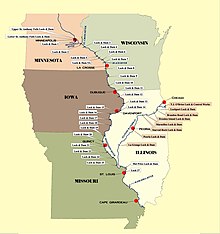
The inland waterways of the United States include more than 25,000 mi (40,000 km) of navigable waters. Much of the commercially important waterways of the United States consist of the Mississippi River System—the Mississippi River and connecting waterways.
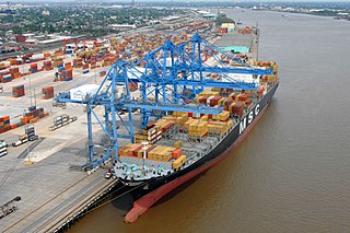
The Port of New Orleans is a significant transport hub located in Louisiana, United States. It serves as an embarkation point for cruise passengers and Louisiana’s sole international container port.

The Port of Antwerp is the port of the city of Antwerp, Belgium. It is located in Flanders, mainly in the province of Antwerp, but also partially in East Flanders. It is a seaport in the heart of Europe accessible to capesize ships. It is Europe's second-largest seaport, after that of Rotterdam. Antwerp stands at the upper end of the tidal estuary of the Scheldt. The estuary is navigable by ships of more than 100,000 Gross Tons as far as 80 km inland. Like the Port of Hamburg, the Port of Antwerp's inland location provides a more central location in Europe than the majority of North Sea ports. Antwerp's docks are connected to the hinterland by rail, road, and river and canal waterways. As a result, the port of Antwerp has become one of Europe's largest seaports, ranking second behind Rotterdam by total freight shipped. Its international rankings vary from 11th to 20th (AAPA). In 2012, the Port of Antwerp handled 14,220 sea trade ships, 57,044 inland barges, and offered liner services to 800 different maritime destinations.

The Lower Mississippi River is the portion of the Mississippi River downstream of Cairo, Illinois. From the confluence of the Ohio River and the Middle Mississippi River at Cairo, the Lower flows just under 1000 miles (1600 km) to the Gulf of Mexico. It is the most heavily travelled component of the Mississippi River System.

The Inner Harbor Navigation Canal Lock—commonly known as Industrial Canal Lock or simply Industrial Lock—is a navigation lock in New Orleans. It connects the Lower Mississippi River to the Industrial Canal and other sea-level waterways. Because it is shorter and narrower than most modern locks on the Mississippi River System, the 1920s vintage lock has become a bottleneck between the nation's two highest-tonnage waterways—the Mississippi and the Gulf Intracoastal Waterway.

The Port of New York and New Jersey is the port district of the New York-Newark metropolitan area, encompassing the region within approximately a 25-mile (40 km) radius of the Statue of Liberty National Monument.

Inland navigation, inland barge transport or inland waterway transport (IWT) is a transport system allowing ships and barges to use inland waterways. These waterways have inland ports, marinas, quays, and wharfs.

The McClellan–Kerr Arkansas River Navigation System (MKARNS) is part of the United States inland waterway system originating at the Tulsa Port of Catoosa and running southeast through Oklahoma and Arkansas to the Mississippi River. The total length of the system is 445 miles (716 km). It was named for two senators, Robert S. Kerr (D-OK) and John L. McClellan (D-AR), who pushed its authorizing legislation through Congress. The system officially opened on June 5, 1971. President Richard M. Nixon attended the opening ceremony. It is operated by the Army Corps of Engineers (USACE).

Chain of Rocks Lock and Dam, also known as Locks No. 27, is a lock situated at the southern end of Chouteau Island near St. Louis, Missouri on the Upper Mississippi River. Its associated dam is just downstream of the Chain of Rocks Bridge, and the lock is located over 3 miles (4.8 km) southeast on the Chain of Rocks canal. The canal and locks allow river traffic to bypass a portion of the river that is unnavigable in low water due to an anticlinal exposure of bedrock in the river—a "chain of rocks".

The Lehigh Canal is a navigable canal that begins at the mouth of Nesquehoning Creek on the Lehigh River in the Lehigh Valley and Northeastern regions of Pennsylvania. It was built in two sections over a span of 20 years beginning in 1818. The lower section spanned the distance between Easton and present-day Jim Thorpe. In Easton, the canal met the Pennsylvania Canal's Delaware Division and Morris Canals, which allowed anthracite coal and other goods to be transported further up the U.S. East Coast. At its greatest extent, the Lehigh Canal was 72 miles (116 km) long.

The Port of Kansas City is an inland port on the Missouri River in Kansas City, Missouri at river mile 367.1, near the confluence with the Kansas River. Kansas City, the second-largest rail hub and third-largest trucking hub in the country, is on marine highway M-70, which extends as far as Pittsburgh and intersects M-55 at St. Louis, allowing shipping to New Orleans, Chicago, Minneapolis and connections to major cities all over the eastern United States. The Missouri inland waterway allows for barge traffic as far upriver as Sioux City, Iowa; however, most of the commercial traffic on the Missouri is concentrated between Kansas City and St. Louis.
The Louisiana International Terminal or LIT is an approved project for a container port at the mouth of the Mississippi. It will be at St. Bernard Parish in Violet and allow container ships with 50-foot drafts – and unlimited lengths, widths, and heights. A $1.8 billion public–private investment has been made and construction is expected to begin in 2025 for an opening in 2028.