Contemporary Australian environmental incidents

Last updated

The following is a maintained list of contemporary Australian environmental and cultural incidents that have resulted in destroyed, degraded or damaged notable cultural or environmental items.

Contents

The intention of this list is to create a hospitable environment for the contribution and creation of a detailed lineage of intentional and unintentional anthropogenic activities or actors that continue to contribute to the ongoing degradation of Australian and First Nations cultural heritage and environmental sites.

The term incidents refers to any significant human activity, accidental or not, that contributes or creates the conditions in which environmental and cultural heritage is degraded. Conditions of degradation can be determined if the item or event, without human interaction would have sustained itself markedly better.

Entries considered suitable for this article

Fish kills also occurred in late 2022 and early 2023. [1]

Conventional ecosystems

Murray Darling fish kills (2018 and January 2019)

Location40 kilometer stretch of the Darling River, both downstream and within Menindee Lakes
Site Description
Menindee Lake Menindee Lakes Finally Refilling.jpeg
Menindee Lake
The Menindee lakes are 7 adjacent lake systems connected to the lower darling river through a series of weirs, channels and levees. The lower darling constitutes all of the Darling river regulated by releases from the Menindee Lakes scheme, thus the Menindee Lakes system is located at the end of the Darling River. [2]

Over 30 species of water birds use the lakes for habitat, including numerous threatened species. The Menindee Lakes play a prominent role in the early stages of native fish lifespan. [3]

The lakes system provides water for numerous towns, including Broken Hill, Menindee and Pooncarie. Due to the flat landscape that makes up the river, along with inconsistent rainfall, flows into the system at the end of the end of darling river are inconsistent. [4] A significant feature of the lakes is the connection with the Lower Darling river via Weir 32, where "Flows into this section of the river support a range of agricultural and environmental assets" [3]  

The Darling river has a prominent involvement in Aboriginal culture dating back over 13,000 years. This region is the traditional land of numerous different nations, though the most prominent group is the Barkinji people. [3] Barkindji means people of the Barka (the river). [5]  

PrecedentThere are significant short and long term factors that contributed to the conditions of the river system causing three mass kill events.
Diagram of the lake and surrounding Darling system. Independent-assessment-2018-19-fish-deaths-interim-report Lower Darling.png
Diagram of the lake and surrounding Darling system.
An independent panel was commissioned by the Australian government to perform this analysis. The report provided for the Australian Government Minister for Agriculture and Water Resources will make up the majority of the events dissection. Discerning between ultimate causes and proximate causes for the event will provide a more articulate understanding of the context and event of the mass fish deaths.

Ultimate causes:

Large fish recruitment and spawning events

Two large inflow events in 2012 and 2016 resulted in conventionally high biomass levels in Lake Pamamaroo & Menindee Weir pools.

"The first was a sequence of high flow events spanning 2010-2012, which filled the Menindee Lakes . After a series of low flow years (2013-2015), in 2016 there was another single significant rainfall event that filled the Menindee Lakes" [4]

During high flow events, native fish move both downstream from the northern tributaries and upstream from the River Murray to greater proximity with the Menindee system. When full, the Menindee systems act as vast nurseries for fish. [4] These inflows and high water levels in the years preceding the fish - death event caused a large influx of both algal and fish presence in the systems.

Weather and Water management

After inflow events in 2016, Lake Menindee was considered at complete water levels. In 2017 - 2018 water was released from Menindee into the lower darling. Drought conditions in western NSW developed from 2016 onward, this cumulatively caused the "two-year total Barwon–Darling inflows" to be the "lowest on record over the past 20 years."

Furthermore: "As part of the regular management operations for the lakes, water was released down the lower Darling system and into the River Murray". [4] Without any considerable in-flow events after 2016, alongside the diversion of water from the Menindee pools, weather levels began decreasing below Weir 32, effectively trapping remaining fish within the pools.

Proximate causes / Late 20-18-2019:

As conditions came to arrest water movements between the Menindee system, significant endogenous factors were also beginning to foster the environments that culminated in the 2018-2019 fish kill offs. As the independent assessment panel further notes: 

"Based on the flow and algal data available, it would be reasonable to assume that persistent thermal stratification occurred in the weir pool from approximately mid-October 2018"

.This stratification causes a major separation of conditions in the water table...

"with high fish and algal biomass in the epilimnion (surface waters) and likely severely hypoxic or anoxic conditions in the hypolimnion (bottom waters)."

This stratification led to significant differences in oxygen and temperature levels between the epilimnion and hypolimnion. Algae concentrations most significantly changed during this event, with WaterNSW algal sampling showing very low concentrations of algae between July–September 2018 (none-detected). By 24 November, biomass levels had increased to over 8mm3/L (red-alert level).
Incidents and result

"Over three separate events between 15 December 2018 and 28 January 2019, millions of native fish died along a 30- to 40-km reach of the Darling–Baaka River adjacent to the town of Menindee, New South Wales (NSW), in the weir pool between Weir 32 and the Menindee Lakes Main Weir (New South Wales Department of Primary Industries 2019)" Kills in the Darling: assessing the impact of the 2018–2019: mass fish kills on the fish communities [6]

The Independent Panel report referenced here (Vertessy, 2019) and the Australian Academy of Science report (Moritz, 2019) [7] concur that the fish death events were caused by destratification of the pool upstream of Weir 32.

The three major mortality events occurred on 16 December 2018 and the 6/19th of January 2019. The Independent assessment identifies three cool changes as the trigger for these two events.

Alongside the final report, a preliminary report prepared by NSW Department of Primary Industries [8] after the second fish death event concluded that observed air changes and the subsequent water temperature falls are responsible for initiating major fish kill events.

December

Between the 12th and 16 December a significant cool change disturbed the stratification layers containing distressed fish and algae and widely different chemical and physical conditions. Average water temperature at 60 cm depth decreased from 27.5 °C on the 12th to 23.1 °C on the 16th, alongside rainfall on the 14th and 15 December. [4] The independent assessment panel notes...

"This weather change likely triggered a mixing event that combined very low oxygen bottom waters with the surface waters where the fish were located."

and..

"A change in conductivity that may be due to mixing of surface and bottom waters occurred in the early morning of 16 December 2018"

This abrupt change altered the conductivity, temperature and oxygen saturations considerably, marking the start of the fish deaths that would occur following the 16th. The majority of deaths occurred in close proximity to Weir 32

January

Upstream from Weir 32 cool changes altered the maximum air temperature from 46 °C on January 4, 2019, to 28.5 °C on January 5. Strong winds and substantial rainfall also occurred, reducing the weather temperature from 30 C on the 4th to 26 C on the 6th. Similar changes occurred on and prior to the two fish kills that occurred in January as demonstrated in the previous event during December.  

Although these two events featured headfirst,

"further broader-scale fish kills occurred throughout, 600 km of the Darling–Baaka River as disconnected refuge pools contracted and water quality deteriorated from June 2019 to March 2020." [6]

The exact number of fish deaths is unknown, though the report produced by Professor Rob Vertessy concluded that over a million fish may have died. [4]

Whitehaven Coal billion litter water theft (2016–2019)

LocationWhitehaven's Maules Creek mine is located 45 km southeast of Narrabri in north-east NSW within the Gunnedah Basin.
Site Description
Maules Creek coal mine Maules Creek coal mine.jpg
Maules Creek coal mine
Located within the Leard state forest, the site continues to operate on and within Gamilaraay land and cultural sites. [9] Leard state forest is noteworthy for containing the "most intensive and intact strands of nationally listed and critically endangered Box-Gum Woodland remaining on the Australian continent" and the " largest area of remnant vegetation remaining in the Liverpool Plains". [10]

Leard state forest is home to 396 native species of plants and animals, 34 threatened species and numerous endangered ecological communities. [9]

As of 2015 "Maules Creek [was] the biggest coal mine under construction and one of the few tier-one, undeveloped coal deposits in Australia." [11]

The area expected to be impacted by the mine in its lifetime is approximately 2,177 ha. This consists of 1655 ha of forest and woodland and a further 413 ha of native grassland and 99 ha of exotic grassland. [12]

PrecedentOpen cut coal mining requires significant water usage to mediate toxic dust and fine particles produced by their operation. Approximately 250 litters of freshwater are required for every single ton of coal extracted and produced. As the CSIRO further elaborates, waters involvement in coal mining includes: [13]
  • transport of ore and waste in slurries and suspension
  • separation of minerals through chemical processes
  • physical separation of material such as in centrifugal separation
  • cooling systems around power generation
  • suppression of dust, both during mineral processing and around conveyors and roads
  • washing equipment
  • dewatering of mines

Whitehaven Coal specifically notes its use of water at Maules Creek site as: [14]

"On site, water is used to suppress dust, to wash the coal in the Coal Handling and Processing Plant (CHPP) and across other miscellaneous areas. Some water is lost through evaporation."

As Whitehaven Coal's water management statement notes:

"The Maules Creek mine’s primary external water source is a 3000ML High Security water licence from the Namoi River, which flows during high rainfall events and from Keepit Dam periodic releases."

More specifically related to the incident:

"Other site water sources include rainfall into the pit and licensed groundwater allocations."

Incident and result Whitehaven Coal was found complacent in two alleged breaches of section 60A(2) of the Water Management Act 2000 by extracting water unlicensed between 2016 and 2019. [15]
Protester blocking mining equipment within Maules Mine ActUp3 011 (13527552964).jpg
Protester blocking mining equipment within Maules Mine
Grant Barnes, Chief Regulatory Officer at the Natural Resources Access Regulator, stated that  "the mine is alleged to have failed to divert clean water from major streams on the Maules Creek site" [16] This was accomplished through the construction of sediment dam (7/MC10) along with the operation of its Western Clean Water Diversion program to its own holding tanks, instead of nearby Back Creek. [17]

Notions suggests that Whitehaven did not take an active role in managing water resources its site was endowed with, instead choosing to use its private position as a primary benefactor of this resource.

The court heard Principal Engineering Hydrologist at PSM, Doug Anderson statement that offense coincided with "the worst drought in living memory" [16] and that the value of that water to the environment had significantly higher value then normal

Justice Pain notes that the ability to prove damages equivalent to a greater fine was more difficult, were: [16]

"The prosecutor cannot prove to the requisite standard that the drought exacerbated actual harm to the environment"

A Whitehaven spokesperson notes: [18]

"Whitehaven has previously publicly addressed aspects of NRAR’s investigation, including noting the complexity of the water management system in NSW and the fact that some of the alleged non-compliances concern practices widely observed in the NSW coal mining sector."

Whitehaven Coal was fined AUD $200,000 for unlawfully extracting 1 billion litters of water in 2021. Large public anger emerged from the perceived lack of severity of this fine. The maximum fine for this level of offense is 2 million AUD. [16]

Adani Abbot Point coal spill (2017)

LocationCaley Valley Wetlands
Site descriptionThe Caley Valley Wetlands is a large coastal wetland ecosystem located ~25 km northwest of Bowen and south-east of Townsville. The wetland is designated to cover ~5,154 hectares and remains one of the only fully functioning wetland systems between Townsville and Bowen. [19] The wetland exists amongst a greater amalgamation of 5 main wetland systems located within the Great Barrier Reef catchment. The Wetland contains over 40,000 birds, made up of over 145 different species. It provides a breeding habitat for at least 24 species, including the most northerly location for coastal nesting black swans. [19]
Location of the Valley Abbot Point.png
Location of the Valley
Further ecosystem participants include
  • Saltwater crocodiles
  • Marine turtles  
  • Dugong and Snubfin Dolphin

As Professor Callum Roberts (2013) describes,  “The density of birds was astonishing, the highest I have ever seen in any wetland. It was immediately clear that this was an extraordinary haven for wildlife ”

The location adjacent to the wetland is mostly owned by North Queensland Bulk Ports corporation. The wetland itself is designated as an Abbot Point State Development Area and is therefore owned by the Coordinator General. [19] Abbot point is a significant export terminal for coal Bowen Basic Coalfields and located directly within the wetlands.
Precedent Cyclone Debbie emerged as a significant tropical cyclone event in late March 2017. The strongest cyclone to strike Queensland since Marica in 2015, Cyclone Debbie was considered the deadliest cyclone to hit Australia since Fifi in 1991. [20]

As the cyclone moved south, the Queensland department of Environment and Science granted "Abbot Point Bulkcoal Pty Ltd a temporary emissions license (TEL) for the period 27 to 30 March 2017, to assist with site water management during and after TC Debbie" [21]

The TEL authorized total suspended solids (TSS) releases of up to 100 milligrams per litre (mg/L) into the Caley Valley Wetland. [21]

Incident and resultInstead, "Adani has now admitted to the Queensland Government that they breached conditions of this license, exceeding their permitted pollution discharge limit to the ocean by more than 800 percent." [22]

This represents a breach of over 26 times the containment limit prescribed to Adani under their existing agreements with the Queensland Environmental authority.  

In the months preceding the runoff incident, government staff undertook a rapid assessment of the adverse effects the runoff created. The Caley Valley Wetland Monitoring Program Progress Report 2017 indicated that...

"In April 2017 government staff undertook a rapid assessment of the wetland and found that although there were indications of recent flooding, there was little visual evidence of coal fines across the whole of the wetland, apart from a site immediately downstream of the licensed discharge point". [23]

The report concluded that in this instance, "this preliminary study found little evidence of contaminants in the surface sediments and waters of the Caley Valley wetland. Sediment samples collected in October 2018 and March 2019 showed that most samples contained trace or no coal fines".

Queensland Department of Environmental Science has its own long-term monitoring program in the Caley Valley Wetland now implemented.

Cultural heritage items

Djab Wurrung directions tree destruction (2018)

LocationDjab Wurrung country where it and lands surrounding Budja Budja (Halls gap) are under the custodianship of Djab Wurrung people. [24]
Site descriptionThe tree was located along a 12 km strip between the town of Buangor and Ararat. [25]

A direction or 'birthing' tree is a traditionally significant tree for Djab Wurrung peoples.  As Djab Wurrung man Zellanach Djab Mara explains: [26]

"[such trees] comes from a time when mobs would mix a child’s placenta with the seeds of a tree, so it would grow with the child and become a place of significant spiritual value." "In the present day, many Djab Wurrung people believe such trees carry their bloodline and act as guardians."

Aboriginal woman and Greens senator Lidia Thorpe expands the importance of such places for Djab Wurrung people in the continuation of living culture:

"When we talk about sacredness within life – or any kind of sacredness – we’re talking about this particular place. It’s a particular place where women give birth. It’s a place where women’s business is conducted. And that’s what we talk about: where women prepare for the birth of children."

Local landowner Mairi Anne Mackenzie said independent arborists had estimated the tree to be approximately 350 years old. [27] Arborists for the Eastern Maar Aboriginal Corporation [28] "have indicated that the tree in question is “highly unlikely” to pre-date European occupation". Furthermore, "Despite its age and majesty, extensive re-assessments did not reveal any characteristics consistent with cultural modification. It did not appear to have been altered by our peoples for usage in our cultural traditions".
Precedent VicRoads and Major Road Projects Victoria, in attempting to reduce road accidents related to the particularly dangerous Western highway, maintain the necessity of expanding the highway to accommodate growing economic and social demands. [29]  Between 2012 - January 2022, there have been 156 motor vehicle incidents, including 17 fatalities and 93 people seriously injured along the highway. It is expected traffic will double by 2025. [29]  
Incident and result  In the preceding year, "Aboriginal landowners negotiated with the Victorian government to save around a dozen of 250 "culturally significant" trees from destruction." [30]

"As beautiful as it was, it wasn't deemed to have cultural values and there is dispute about that and we respect and understand that, but we've been guided by our knowledge holders and cultural experts," -  Jason Mifsud, Chair of EMAC [31]

These claims are contested by other Djab Wurrung peoples.  

Representatives from the Djab Wurrung Heritage Protection Embassy filed three separate injunctions against Environment Minister Sussan Ley decision making in the matter. The first of which was successful in discarding Ms.leys original approval. Although the environment minister was required to reconsider her decision making, the commonwealth in mid 2019 eventually denied the cultural significance of the trees, setting the precedent for their destruction later in the year. [32]

Protecting culturally threatened sites has been the focus of many Djab Wurrung people, forming an embassy in proximity to the trees in mid-2018. [27]  

On 26 October 202012 police forces issued a move order to the remaining protestors surrounding the site. Approximately 50 people were arrested, in an amalgamation of charges related to failing to comply with the Chief Health Officer directions and obstructing police. [33]

The tree was destroyed on 26 October 2020.

See also

Related Research Articles

<span class="mw-page-title-main">Grampians National Park</span> Protected area in Victoria, Australia

The Grampians National Park commonly referred to as the Grampians, is a national park located in the Grampians region of Victoria, Australia. The Jardwadjali name for the mountain range itself is Gariwerd.

<span class="mw-page-title-main">Murrumbidgee River</span> Major river in southeastern Australia

The Murrumbidgee River is a major tributary of the Murray River within the Murray–Darling basin and the second longest river in Australia. It flows through the Australian state of New South Wales and the Australian Capital Territory, descending 1,500 metres (4,900 ft) over 1,485 kilometres (923 mi), generally in a west-northwesterly direction from the foot of Peppercorn Hill in the Fiery Range of the Snowy Mountains towards its confluence with the Murray River near Boundary Bend.

<span class="mw-page-title-main">Darling River</span> Major river in Australia

The Darling River is the third-longest river in Australia, measuring 1,472 kilometres (915 mi) from its source in northern New South Wales to its confluence with the Murray River at Wentworth. Including its longest contiguous tributaries it is 2,844 km (1,767 mi) long, making it the longest river system in Australia. The Darling River is the outback's most famous waterway.

<span class="mw-page-title-main">Murray–Darling basin</span> Largest Australian river catchment

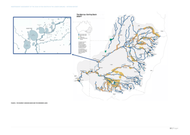
The Murray–Darling Basin is a large geographical area in the interior of southeastern Australia, encompassing the drainage basin of the tributaries of the Murray River, Australia's longest river, and the Darling River, a right tributary of the Murray and Australia's third-longest river. The Basin, which includes six of Australia's seven longest rivers and covers around one-seventh of the Australian landmass, is one of the country's most significant agricultural areas providing one-third of Australia's food supply. Located west of the Great Dividing Range, it drains southwest into the Great Australian Bight and spans most of the states of New South Wales and Victoria, the Australian Capital Territory, and parts of the states of Queensland and South Australia.

<span class="mw-page-title-main">Menindee, New South Wales</span> Town in New South Wales, Australia

Menindee is a small town in the far west of New South Wales, Australia, in Central Darling Shire, on the banks of the Darling River, with a sign-posted population of 980 and a 2016 census population of 551. Menindee was the first town to be established on the Darling River. There are two distinct theories for the derivation of the township’s name: (a) from the Barkindji word "minandichi" for the shallow ephemeral lake north-west of the present-day township; (b) from the Barkindji word 'milhthaka', meaning "yolk of an egg".

<span class="mw-page-title-main">Barwon River (New South Wales)</span> River in New South Wales, Australia

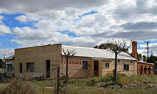
Barwon River, a perennial river that is part of the Murray–Darling basin, is located in the north-west slopes and Orana regions of New South Wales, Australia.

The Boonwurrung, also spelt Bunurong or Bun wurrung, are an Aboriginal people of the Kulin nation, who are the traditional owners of the land from the Werribee River to Wilsons Promontory in the Australian state of Victoria. Their territory includes part of what is now the city and suburbs of Melbourne. They were called the Western Port or Port Philip tribe by the early settlers, and were in alliance with other tribes in the Kulin nation, having particularly strong ties to the Wurundjeri people.

<span class="mw-page-title-main">Hacking River</span> River in Sydney, New South Wales, Australia

The Hacking River is a watercourse that is located in the Southern Sydney region of New South Wales in Australia. For thousands of years traditional owners called the river Deeban, however the colonial settlers renamed the river after Henry Hacking, a British seaman who killed Pemulwuy and was a pilot at Port Jackson in colonial New South Wales.

<span class="mw-page-title-main">Lake Bolac, Victoria</span> Town in Victoria, Australia

Lake Bolac is a town in the Western District region of Victoria, Australia. The town is on the shores of Lake Bolac, and the Glenelg Highway passes through the town. At the 2021 census, Lake Bolac and the surrounding area had a population of 368.

The Jardwadjali (Yartwatjali), also known as the Jaadwa, are an Aboriginal Australian people of the state of Victoria, whose traditional lands occupy the lands in the upper Wimmera River watershed east to Gariwerd (Grampians) and west to Lake Bringalbert.

The Djab Wurrung, also spelt Djabwurrung, Tjapwurrung, Tjap Wurrung, or Djapwarrung, people are Aboriginal Australians whose country is the volcanic plains of central Victoria from the Mount William Range of Gariwerd in the west to the Pyrenees range in the east encompassing the Wimmera River flowing north and the headwaters of the Hopkins River flowing south. The towns of Ararat, Stawell and Hamilton are within their territory. There were 41 Djab Wurrung clans who formed an alliance with the neighbouring Jardwadjali people through intermarriage, shared culture, trade and moiety system before colonisation. Their lands were conquered but never ceded.

The Djargurd Wurrong are Aboriginal Australian people of the Western district of the State of Victoria, and traditionally occupied the territory between Mount Emu Creek and Lake Corangamite.

<span class="mw-page-title-main">Clarrie Hall Dam</span> Dam in New South Wales, Australia

Clarrie Hall Dam is a minor ungated concrete faced rockfill embankment dam with an uncontrolled concrete-lined chute spillway across the Doon Doon Creek, located upstream of the small town of Uki, in the Northern Rivers region of New South Wales, Australia. The main purpose of the dam is for water supply and it creates the artificial Lake Clarrie Hall.

<span class="mw-page-title-main">Paroo-Darling National Park</span> Protected area in New South Wales, Australia

The Paroo-Darling National Park is a protected national park that is located in the Far West region of New South Wales, in eastern Australia. The 178,053-hectare (439,980-acre) national park spans two distinct regions in the outback area. This region covers the arid catchments of the Paroo River and the Paroo-Darling confluence to the south.

<span class="mw-page-title-main">Yanga National Park</span> Protected area in New South Wales, Australia

The Yanga National Park is a newly formed national park, located near the township of Balranald in south- western New South Wales. It covers an area of 66,734 hectares which includes 1,932 hectares of Yanga Nature Reserve, and has a frontage of 170 kilometres (110 mi) on the Murrumbidgee River. It is largely located in the Lower Murrumbidgee Floodplain, which is included on A Directory of Important Wetlands in Australia because of its importance as a breeding site for waterbirds when flooded.

<span class="mw-page-title-main">Menindee Lakes</span> Shallow freshwater lakes in New South Wales

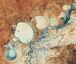
The Menindee Lakes is a system of 9 large, but relatively shallow lakes, located in south-west New South Wales on the Darling (Barka) River, about 200 km upstream of the Darling River's junction with the River Murray. The Darling River is fed by nine major tributary river systems flowing from south-east Queensland and north and central NSW. The town of Menindee is close to the lakes and the nearest city is Broken Hill.

<span class="mw-page-title-main">Great Darling Anabranch</span> River in New South Wales, Australia

The Great Darling Anabranch, commonly called the Darling Anabranch, is an anabranch and ancestral path of the Darling River in the lower Murray-Darling basin in the Far West and Riverina regions of New South Wales, Australia.

The Cumbung Swamp, also known as the Great Cumbung Swamp, is a wetland made up of the ecosystems surrounding the junction of the Murrumbidgee and Lachlan Rivers in the South West Region of New South Wales. When it is at full capacity, the swamp supports a large population of migratory waterbirds as well as one of the largest reed swamps in the Murray Darling Basin.

<span class="mw-page-title-main">Limeburners Creek National Park</span> Protected area in New South Wales, Australia

Limeburners Creek National Park is a protected national park on the Mid North Coast of New South Wales, Australia. The 91.2 km national park is located 5 km (3.1 mi) to the north of Port Macquarie and exists across both the Kempsey Shire and Port Macquarie-Hastings Council local government areas, but is chiefly managed by National Parks and Wildlife Service. The area was originally erected as a nature reserve but this reservation was revoked when it became formally recognised as a national park in 2010 under the National Parks and Wildlife Act (1974). Many threatened ecological habitats and species of fauna and flora are found within this park, alongside several heritage sites of cultural significance, particularly to the local Birpai and Dunghutti people upon whose land the park exists. The protected status of this national park is largely owing to the ecological and cultural value of the area, in addition to the value of the ecosystems to further scientific research.

<span class="mw-page-title-main">Djab Wurrung Heritage Protection Embassy</span>

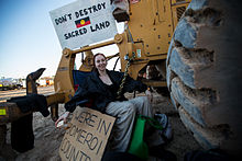
The Djab Wurrung Heritage Protection Embassy or Djab Wurrung Embassy was an activist space from 2018 to 2021 that comprised three camps near Buangor, Victoria. The Embassy's goal was to block the Victorian Government from destroying sacred birthing trees and advocate for Aboriginal sovereignty and land rights. The Embassy was led by Djab Wurrung people and received visitors and support from First Nations people and the broader community. The sites of the Embassy were dismantled during arrests in 2020, during which the 'Directions Tree' was destroyed.

References

  1. "Fish kills in NSW". www.dpi.nsw.gov.au. 2023. Archived from the original on 15 March 2023.
  2. "Lower Darling - Catchment snapshot". NSW Department of Planning and Environment. 2 August 2018.
  3. 1 2 3 "A profile of the Darling River system" (PDF). NSW Office of Environment & Heritage. 2017.
  4. 1 2 3 4 5 6 Vertessy, Robert (2019). "Independent Assessment of the 2018-2019 Fish Deaths In the Lower Darling" (PDF). Independent Panel via Murray-Darling Basin Authority.
  5. "Indigenous Heritage". Murray Darling Association.
  6. 1 2 Stocks, Jerom R. (9 September 2021). "Kills in the Darling: assessing the impact of the 2018–20 mass fish kills on the fish communities of the Lower Darling– Baaka River, a large lowland river of south-eastern Australia". Marine and Freshwater Research, 2022: 73, 159–177 via CSIRO.
  7. Moritz, Craig (February 2019). "Investigation of the causes of mass fish kills in the Menindee Region NSW over the summer of 2018–2019". Australian Academy of Science.
  8. "Fish Death Interim Investigation Report - Lower Darling River Fish Death Event, Menindee 2018/19" (PDF). Department of Primary Industries. 2019.
  9. 1 2 Arthurslea (2016). "Icons Under Threat Leard State Forest NCC 2012" via Yumpu.{{cite journal}}: Cite journal requires |journal= (help)
  10. Kibble, Gilligan and West (2012) NSW Planning Assessment Commission Review Report: Maules Creek Coal Project p11
  11. "Maules Creek Coal Mine, New South Wales". Mining Technology. 2015.
  12. "Maules Creek Coal Mine: Project Approval Modification Environmental Assessment". Hansen Bailey - Environmental Consultants. April 2013.
  13. Prosser, Ian (2011). "Water in mining and industry". CSIRO.
  14. "Water Management" (PDF). WhiteHaven Coal. 2019.
  15. "Whitehaven's Maules Creek alleged water theft further proof Vickery must not be approved". Lock The Gate. July 2020.
  16. 1 2 3 4 Bell, Patrick (Nov 2021). "'Slap on the wrist': Farmers fume as Whitehaven Coal fined $200,000 for unlawfully taking water". ABC News.
  17. "Enforceable undertaking for Maules Creek Coal Pty Ltd". Natural Resource Access Regulator. 2021.
  18. Hannam, Peter (202). "Coal mining company accused of water theft". Sydney Morning Herald.
  19. 1 2 3 "The Values of the Caley Valley Wetlands Report". Australian Marine Conservation Society. 2013.
  20. Kamenev, Marina. "Australia's worst cyclones: timeline". Australian Geographic.
  21. 1 2 "Preliminary assessment of impacts to Caley Valley Wetlands from Abbot Point Coal Terminal post Tropical Cyclone Debbie" (PDF). Department of Science, Information Technology and Innovation. 2017.
  22. "Adani Abbot Point coal spill: Carmichael coal mine won't be any different". Australian Conservation Foundation. 2017.
  23. "Caley Valley Wetlands - Ongoing Monitoring Progress Report". Water Quality and Investigations Science Delivery - Division Department of Environment and Science. 2019.
  24. Djab Wurrung People. Budja Budja Aboriginal Cooperative.  
  25. Jacks, T (2020). "jab Wurrung trees granted protection until February". The Age.
  26. "The Directions Trees Are More Than Just Trees". 3knd. 2021.
  27. 1 2 Perkins, M (2020). "'Devastated': Anger after 'culturally significant' tree cut down at highway site". The Sydney Morning Herald.
  28. "Media release - Fiddle back tree and Western Hwy". Eastern Maar Aboriginal Corporation. 2020.
  29. 1 2 "Western Highway Duplication". Victoria’s Big Build. 2022.
  30. "Djab Wurrung tree: Anger over sacred Aboriginal tree bulldozed for highway". BBC News. 2020.
  31. Higgins, Isabella (2022). "The destruction of a mighty fiddleback in Victoria sparks a common conundrum for Aboriginal Australians". 7.30 ABC.
  32. King, C (2022). "Western Highway's culturally significant trees denied Commonwealth protectio". ABC News.
  33. Bell, S (2020). "50 arrests as controversy rages over felling of Djab Wurrung tree at Western Highway upgrade site". ABC News.