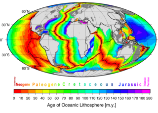
The East Pacific Rise is a mid-ocean ridge, a divergent tectonic plate boundary located along the floor of the Pacific Ocean. It separates the Pacific Plate to the west from the North American Plate, the Rivera Plate, the Cocos Plate, the Nazca Plate, and the Antarctic Plate. It runs south from the Gulf of California in the Salton Sea basin in Southern California to a point near 55° S, 130° W, where it joins the Pacific-Antarctic Ridge trending west-southwest towards Antarctica, near New Zealand. Much of the rise lies about 3200 km (2000 mi) off the South American coast and rises about 1,800–2,700 m (6,000–9,000 ft) above the surrounding seafloor.

A submarine canyon is a steep-sided valley cut into the seabed of the continental slope, sometimes extending well onto the continental shelf, having nearly vertical walls, and occasionally having canyon wall heights of up to 5 km, from canyon floor to canyon rim, as with the Great Bahama Canyon. Just as above-sea-level canyons serve as channels for the flow of water across land, submarine canyons serve as channels for the flow of turbidity currents across the seafloor. Turbidity currents are flows of dense, sediment laden waters that are supplied by rivers, or generated on the seabed by storms, submarine landslides, earthquakes, and other soil disturbances. Turbidity currents travel down slope at great speed, eroding the continental slope and finally depositing sediment onto the abyssal plain, where the particles settle out.

A turbidity current is most typically an underwater current of usually rapidly moving, sediment-laden water moving down a slope; although current research (2018) indicates that water-saturated sediment may be the primary actor in the process. Turbidity currents can also occur in other fluids besides water.

The Iceland hotspot is a hotspot which is partly responsible for the high volcanic activity which has formed the Iceland Plateau and the island of Iceland.
The term iridium anomaly commonly refers to an unusual abundance of the chemical element iridium in a layer of rock strata at the Cretaceous–Paleogene (K–Pg) boundary. The unusually high concentration of a rare metal like iridium is often taken as evidence for an extraterrestrial impact event.

Marine sediment, or ocean sediment, or seafloor sediment, are deposits of insoluble particles that have accumulated on the seafloor. These particles have their origins in soil and rocks and have been transported from the land to the sea, mainly by rivers but also by dust carried by wind and by the flow of glaciers into the sea. Additional deposits come from marine organisms and chemical precipitation in seawater, as well as from underwater volcanoes and meteorite debris.

Submarine landslides are marine landslides that transport sediment across the continental shelf and into the deep ocean. A submarine landslide is initiated when the downwards driving stress exceeds the resisting stress of the seafloor slope material, causing movements along one or more concave to planar rupture surfaces. Submarine landslides take place in a variety of different settings, including planes as low as 1°, and can cause significant damage to both life and property. Recent advances have been made in understanding the nature and processes of submarine landslides through the use of sidescan sonar and other seafloor mapping technology.

A contourite is a sedimentary deposit commonly formed on continental rise to lower slope settings, although they may occur anywhere that is below storm wave base. Countourites are produced by thermohaline-induced deepwater bottom currents and may be influenced by wind or tidal forces. The geomorphology of contourite deposits is mainly influenced by the deepwater bottom-current velocity, sediment supply, and seafloor topography.
In geology, the slab is a significant constituent of subduction zones.

Congo Canyon is a submarine canyon found at the end of the Congo River in Africa. It is one of the largest submarine canyons in the world.

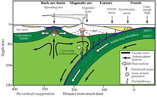
In plate tectonics, slab detachment or slab break-off may occur during continent-continent or arc-continent collisions. When the continental margin of the subducting plate reaches the oceanic trench of the subduction zone, the more buoyant continental crust will in normal circumstances experience only a limited amount of subduction into the asthenosphere. The slab pull forces will, however, still be present and this normally leads to the breaking off or detachment of the descending slab from the rest of the plate. The isostatic response to the detachment of the downgoing slab is rapid uplift. Slab detachment is also followed by the upwelling of relatively hot asthenosphere to fill the gap created, leading in many cases to magmatism.
Hollister Ridge is a group of seamounts in the Pacific Ocean. They lie west from the Pacific-Antarctic Ridge and form three ridges that form a line; one of the ridges rises to a depth of 100 metres (330 ft) and in the past formed an island. The seamounts are composed out of basaltic and other rocks and their ages range from about 2.5 million years ago to latest Pleistocene; an acoustic swarm recorded in the southern Pacific Ocean in 1991-1992 is considered to be the manifestation of a historical eruption of the Hollister Ridge.
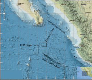
The RISE Project was a 1979 international marine research project which mapped and investigated seafloor spreading in the Pacific Ocean, at the crest of the East Pacific Rise (EPR) at 21° north latitude. Using a deep sea submersible (ALVIN) to search for hydrothermal activity at depths around 2600 meters, the project discovered a series of vents emitting dark mineral particles at extremely high temperatures which gave rise to the popular name, "black smokers". Biologic communities found at 21° N vents, based on chemosynthesis and similar to those found at the Galapagos spreading center, established that these communities are not unique. Discovery of a deep-sea ecosystem not based on sunlight spurred theories of the origin of life on Earth.
South Arch volcanic field is an underwater volcanic field south of Hawaiʻi Island. It was active during the last 10,000 years, and covers an area of 35 by 50 kilometres at a depth of 4,950 metres (16,240 ft).
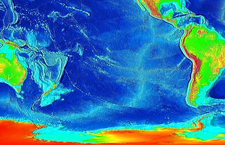
Marine geophysics is the scientific discipline that employs methods of geophysics to study the world's ocean basins and continental margins, particularly the solid earth beneath the ocean. It shares objectives with marine geology, which uses sedimentological, paleontological, and geochemical methods. Marine geophysical data analyses led to the theories of seafloor spreading and plate tectonics.
Cyclic steps are rhythmic bedforms associated with Froude super-critical flow instability. They are a type of sediment wave, and are created when supercritical sediment-laden water travels downslope through sediment beds. Each ‘step’ has a steep drop, and together they tend to migrate upstream. On the ocean floor, this phenomenon was first shown to be possible in 2006, although it was observed in open-channel flows over a decade earlier. Geological features appearing to be submarine cyclic steps have been detected in the northern lowlands of Mars in the Aeolis Mensae region, providing evidence of an ancient Martian ocean.

Ariel Anbar is an isotope geochemist and President’s Professor at Arizona State University. He has published over 180 refereed papers on topics ranging from the origins of Earth’s atmosphere to detecting life on other worlds to diagnosing human disease.
Delia Wanda Oppo is an American scientist who works on paleoceanography where she focuses on past variations in water circulation and the subsequent impact on Earth's climate system. She was elected a fellow of the American Geophysical Union in 2014.
Rachel Haymon is a marine geologist known for her work linking geological and biological processes occurring at deep-sea hydrothermal vents. In 2005 she was elected a fellow of the Geological Society of America.
Marta E. Torres is a marine geologist known for her work on the geochemistry of cold seeps and methane hydrates. She is a professor at Oregon State University, and an elected fellow of the Geochemical Society and the Geological Society of America.