
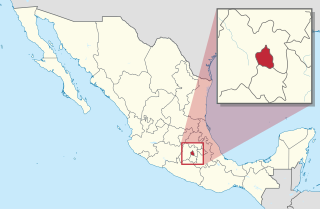
Venustiano Carranza is a borough in the Mexico City. Venustiano Carranza extends from the far eastern portion of the historic center of Mexico City eastward to the Peñón de los Baños and the border dividing the then Federal District from the State of Mexico. Historically, most of the territory was under Lake Texcoco, but over the colonial period into the 20th century, the lake dried up and today the area is completely urbanized. The borough is home to three of Mexico City's major traditional markets, including La Merced, the National Archives of Mexico, the Palacio Legislativo de San Lázaro, the TAPO intercity bus terminal and the Mexico City Airport.
Mexico City is one of the 32 federal entities of Mexico, the others being the 31 states. It was named Distrito Federal up to February 5, 2016, when it was officially renamed the Ciudad de México. According to the 2020 Mexican Census, it is the second most populated entity with 9,209,944 inhabitants and the smallest by land area spanning 1,494.3 square kilometres (577.0 sq mi).

Francisco Jerónimo de Jesús Lagos Cházaro Mortero was the acting President of Mexico designated by the Convention of Aguascalientes from June 10, 1915 to October 10, 1915.
In Mexican history, a plan was a declaration of principles announced in conjunction with a rebellion, usually armed, against the central government of the country. Mexican plans were often more formal than the pronunciamientos that were their equivalent elsewhere in Spanish America and Spain. Some were as detailed as the United States Declaration of Independence. Some plans simply announced that the current government was null and void and that the signer of the plan was the new president.
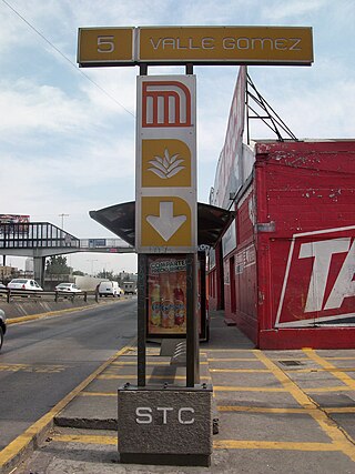
Valle Gómez metro station is a Mexico City Metro station within the limits of Gustavo A. Madero and Venustiano Carranza, in Mexico City. It is an underground station with two side platforms, served by Line 5, between Misterios and Consulado stations. Valle Gómez station serves the colonias of 7 de Noviembre and Valle Gómez; the station receives its name from the latter. The station's pictogram features an agave plant. Valle Gómez metro station was opened on 1 July 1982, on the first day of the La Raza–Pantitlán service. In 2019, the station had an average daily ridership of 4,416 passengers, making it the 190th busiest station in the network and the least busy of the line.

The historic center of Mexico City, also known as the Centro or Centro Histórico, is the central neighborhood in Mexico City, Mexico, focused on Zócalo or main plaza and extending in all directions for a number of blocks, with its farthest extent being west to the Alameda Central. The Zocalo is the largest plaza in Latin America. It can hold up to nearly 100,000 people.

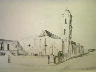
The Church of San Bernardo stands at the corner of Avenida 20 de Noviembre and Venustiano Carranza Street just south of the Zocalo or main plaza of Mexico City. It was part of a convent of the same name that was founded in 1636, but was closed along with all convents and monasteries during the La Reforma period in 1861. Currently, only the church remains of the convent complex.
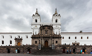
The Basilica and Convent of San Francisco, commonly known as el San Francisco, is a Catholic basilica that stands in the middle of the historic center of Quito, in front of the square of the same name. It is the oldest and most significant religious site in Ecuador. The structure is the largest architectural complex within the historic centers of all of South America, and for this reason it was known as "El Escorial of the New World". San Francisco is considered a jewel of continental architecture for its mixture of different styles combined throughout more than 150 years of construction. San Francisco is part of the UNESCO World Heritage Site "City of Quito".

The Palace of Iturbide is a large palatial residence located in the historic center of Mexico City at Madero Street #17. It was built by the Count of San Mateo Valparaíso as a wedding gift for his daughter. It gained the name “Palace of Iturbide” because Agustín de Iturbide lived there and accepted the crown of the First Mexican Empire at the palace after independence from Spain. Today, the restored building houses the Fomento Cultural Banamex; it has been renamed the Palacio de Cultura Banamex.
The Convent of Nuestra Señora de La Merced was a Roman Catholic colonial religious complex in present-day Historic center of Mexico City, that was destroyed to give more space to future buildings. The cloister is all that is left of a monastery complex built in the late 16th and early 17th century by the Mercedarian order. It is located on Uruguay and Talavera Streets in the historic downtown of Mexico City. The complex lent its name to the area around it, La Merced, which in turn, inspired the name of the metro station and the well-known neighborhood Market.

The Church of San Felipe Neri, commonly known as "La Profesa", is a Roman Catholic parish church that was established by the Society of Jesus late in the 16th century as the church of a community of professed Jesuits. The church is considered to be an important transitional work between the more sober or moderate Baroque style of the 17th century and the extremely decorated manifestations of the Baroque of the 18th century in Mexico.

The Casa de los Azulejos or Palacio de los Condes del Valle de Orizaba is an 18th-century Baroque palace in Mexico City, built by the Count of the Valle de Orizaba family. The building is distinguished by its facade, which is covered on three sides by blue and white colonial Talavera tiles from Puebla state. The palace remained in private hands until near the end of the 19th century. It changed hands several times before being bought by the Sanborns brothers who expanded their soda fountain/drugstore business into one of the best-recognized restaurant chains in Mexico. The house today serves as their flagship restaurant.

The Borda House, located on 27, 29 and 33 Madero Street, and 26-28 Bolivar streets in the historic center of Mexico City, originally belonged to the Frenchman José de la Borda who was one of the richest men in New Spain in the 18th century. It stands out due to its notable architectural features such as the sculpted stone decorative details on the ground floor. The original building encompassed the entire city block. It had various inner courtyards, and Borda had an ironwork balcony built all the way around the building, supported by angles in the shape of rooster feet. This allowed one to walk all the way around the building on the outside.
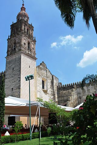
The Cuernavaca Cathedral is the Roman Catholic church of the Diocese of Cuernavaca, located in the city of Cuernavaca, Morelos, Mexico. The church and its surrounding monastery is one of the early 16th century monasteries in the vicinity of the Popocatepetl volcano inscribed as a World Heritage Site by UNESCO, built initially for evangelization efforts of indigenous people after the Spanish conquest of the Aztec Empire. By the 18th century, the church of the monastery began to function as the parish church of the city and in the late 19th century, it was elevated to the rank of a cathedral. Unlike many cathedrals in Mexico, this one does not face the city's main square, but rather is located just to the south, in its own walled compound, which it shares with a number of other structures. Unlike the other monastery structures from its time, the importance of this church provoked a number of renovation projects, the last of which occurred in 1957. This one took out the remaining older decorations of the interior and replaced them with simple modern ones. This renovation work also uncovered a 17th-century mural that covers 400 square metres (4,300 sq ft) of the interior walls and narrates the story of Philip of Jesus and twenty three other missionaries who were crucified in Japan.

La Merced is a barrio or a neighborhood of Mexico City defined by its socioeconomics and history rather than by an official designation. It extends over the southeast of the historic center of Mexico City and is one of the oldest sections of the city, established over 700 years ago by the Mexica as part of the founding of Tenochtitlan. Over its history the area was associated with commerce, first as a major docking area for boats bringing goods to Tenochtitlan/Mexico City on Lake Texcoco, later via canals as the lake was slowly drained. In the latter 19th century, the La Merced market was established in the area replacing the massive La Merced monastery which was almost completely destroyed in the 1860s. This market was established to centralize the marketing of foodstuffs for the city on one area. The first La Merced market was built in 1890 and then replaced by the current building in 1957, one of the largest traditional Mexican markets in Mexico City. In the 1980s, the wholesale function of this market was taken over by the newly constructed Centro de Abasto in the south of the city, with the barrio then going into economic and social decline, with the area having problems with poverty, prostitution and population loss. Although there have been efforts to revitalize the area and the La Merced market remains important.

Francisco I. Madero Avenue, commonly known as simply Madero Street, is a geographically and historically significant pedestrian street of Mexico City and a major thoroughfare of the historic city center. It has an east–west orientation from Zócalo to the Eje Central. From that point the street is called Avenida Juárez and becomes accessible to one-way traffic from one of the city's main boulevards, the Paseo de la Reforma.

Avenida Juárez is a street in the Historic Center of Mexico City flanking the south side of the centuries-old Alameda Central park.
The Casasola Archive is a photographic archive of Mexican history and culture, the foundational collection of the photo archive, Fototeca Nacional, administered by the Mexican government. The archive contains important historical photos from the regime of Porfirio Diaz and the Mexican Revolution. The main collection was compiled by Agustín Víctor Casasola, a photo journalist in Mexico City. The archive contains his own work as well as that of some 500 other photographers, with both positive prints and negative films, in various formats and on various photographic media. Since 1976, it is preserved in the climate-controlled rooms in a former colonial-era Franciscan convent, now the National Photo Library, of the National Institute of Anthropology and History (INAH) in Pachuca, Hidalgo, Mexico. The building houses the photographic archive and has exhibition spaces. The photo library currently gathers images in 39 sections, with a total of 850,000 items.
Juan Agustín Morfi was a Franciscan monk, born in Asturias, Spain, in 1735, who died in Mexico, New Spain, in 1783. He is considered the most important chronicler and historian of the New Philippines; Mariano Errasti ranks Morfi among the most prodigious figures in five centuries of Franciscan work in America.
Jardín Balbuena is a neighborhood in Venustiano Carranza, Mexico City, east of the historic center. The neighborhood was developed in the early 1950s and most of its infrastructure was designed by architects Mario Pani and Agustín Landa Verdugo. Jardín Balbuena is the seat of Venustiano Carranza, as it houses the headquarters of the borough.


