
In architecture, a folly is a building constructed primarily for decoration, but suggesting through its appearance some other purpose, or of such extravagant appearance that it transcends the range of usual garden buildings.

West Somerset was a local government district in the English county of Somerset from 1974 to 2019. The council covered a largely rural area, with a population of 34,900 in an area of 740 square kilometres (290 sq mi); it was the least populous non-unitary district in England. According to figures released by the Office for National Statistics in 2009, the population of West Somerset had the oldest average age in the United Kingdom at 52. The largest centres of population were the coastal towns of Minehead and Watchet (4,400).

Dunster is a village and civil parish in Somerset, England, within the north-eastern boundary of Exmoor National Park. It lies on the Bristol Channel 2.5 miles (4 km) southeast of Minehead and 20 miles (32 km) northwest of Taunton. At the 2011 Census, it had a population of 817.
Barwick is a village and parish in Somerset, England, about 2 miles (3.2 km) south of Yeovil and on the border with Dorset. The parish, which includes the village of Stoford, has a population of 1,221.
Clevedon School, formerly known as Clevedon Community School, is a coeducational secondary school located in Clevedon, North Somerset, England. It has over 1350 pupils, in years 7 to 11 in the Lower School and 12 to 13 in the Upper School or sixth form. The school recently regained its Language College status. As of 2024 the headteacher is Jim Smith. The school was part of the Clevedon Learning Trust, a Multi-Academy Trust formed on 1 January 2015 by CEO John Wells. As of 1st March 2023, Clevedon Learning Trust merged with Futura Learning Partnership, with schools in Bristol, North Somerset and Somerset.

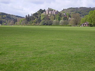
Dunster Castle is a former motte and bailey castle, now a country house, in the village of Dunster, Somerset, England. The castle lies on the top of a steep hill called the Tor, and has been fortified since the late Anglo-Saxon period. After the Norman Conquest of England in the 11th century, William de Mohun constructed a timber castle on the site as part of the pacification of Somerset. A stone shell keep was built on the motte by the start of the 12th century, and the castle survived a siege during the early years of the Anarchy. At the end of the 14th century the de Mohuns sold the castle to the Luttrell family, who continued to occupy the property until the late 20th century.
The year 1775 in architecture involved some significant events.
Coneygar is a suburb of Bridport in Dorset, England. It is also common to find its use throughout the Cotswolds and other rural areas.

The Grade I listed buildings in Somerset, England, demonstrate the history and diversity of its architecture. The ceremonial county of Somerset consists of a non-metropolitan county, administered by Somerset County Council, which is divided into five districts, and two unitary authorities. The districts of Somerset are West Somerset, South Somerset, Taunton Deane, Mendip and Sedgemoor. The two administratively independent unitary authorities, which were established on 1 April 1996 following the breakup of the county of Avon, are North Somerset and Bath and North East Somerset. These unitary authorities include areas that were once part of Somerset before the creation of Avon in 1974.

The Court House in East Quantoxhead, Somerset, England has a medieval tower and other parts of the building which date from the 17th century. It has been designated as a Grade I listed building.
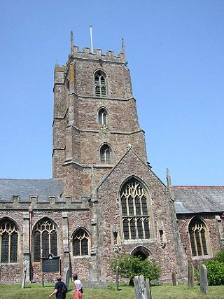
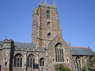
The Priory Church of St George in Dunster, Somerset, England, is predominantly 15th-century with evidence of 12th- and 13th-century work. It has been designated as a Grade I listed building.

The Yarn Market in Dunster, Somerset, England was built in the early 17th century. It has been designated as a Grade I listed building and scheduled monument. Dunster was an important market place in the Middle Ages particularly following the construction of Dunster Castle and the establishment of the Priory Church of St George.
Dunster Priory was established as a Benedictine monastery around 1100 in Dunster, Somerset, England.

The Butter Cross in Dunster within the English county of Somerset is a Grade II* listed building and scheduled monument. The cross was originally erected in the late 14th or early 15th century in the main street, and was moved to its current site in the late 18th or early 19th century. Although the head of the cross is missing, the shaft and socket stone are original. The cross is in the care of English Heritage and is managed by the National Trust.

Henry Fownes Luttrell, of Dunster Castle, Somerset, was High Sheriff of Somerset from 1754 to 1755 and a Member of Parliament for the borough of Minehead from 1768 to 1774.
There are over 670 scheduled monuments in the ceremonial county of Somerset in South West England. The county consists of a non-metropolitan county, administered by Somerset County Council, which is divided into five districts, and two unitary authorities. The districts of Somerset are West Somerset, South Somerset, Taunton Deane, Mendip and Sedgemoor. The two administratively independent unitary authorities, which were established on 1 April 1996 following the breakup of the county of Avon, are North Somerset and Bath and North East Somerset. These unitary authorities include areas that were once part of Somerset before the creation of Avon in 1974.

Richard Phelps (1710–1785) was an 18th-century English portrait painter and designer. He painted portraits of gentry, a number of which are in the National Trust, Dunster Castle, University of Oxford, National Portrait Gallery, London, and other museums. The British Museum has an album of 312 of his drawings. Phelps was also a landscape designer, who was hired by Henry Fownes Luttrell to update the grounds of Dunster Castle.
The feudal barony of Dunster was an English feudal barony with its caput at Dunster Castle in Somerset. During the reign of King Henry I (1100–1135) the barony comprised forty knight's fees and was later enlarged. In about 1150 the manors retained in demesne were Dunster, Minehead, Cutcombe, Kilton and Carhampton in Somerset, and Ham in Dorset.

