
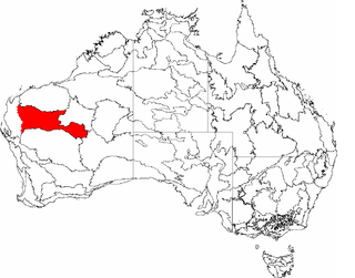
Coolgardie is an Australian bioregion consisting of an area of low hills and plains of infertile sandy soil in Western Australia. [1] [2] It includes much of the Great Western Woodlands.
Coolgardie is an Australian bioregion consisting of an area of low hills and plains of infertile sandy soil in Western Australia. [1] [2] It includes much of the Great Western Woodlands.
This is a transition zone between the Mediterranean climate of Australia's south-west coast and the country's dry interior. The poor soil makes it unsuitable for agriculture but Coolgardie has been a gold and nickel mining area.
It is bounded on the north by the arid Murchison bioregion, characterized by open Mulga woodlands and steppe. The low shrublands of the arid Nullarbor Plain lie to the east.
The Mallee bioregion adjoins Coolgardie on the south. Jarrah Forest bioregion is to the west.
The Coolgardie bioregion, together with the coastal Hampton bioregion to the southeast, constitute the Coolgardie woodlands ecoregion defined by the World Wildlife Fund. [3]
The low hills are home to woodland of endemic species of eucalyptus while the sand plains are covered in scrubland. The areas nearer the west coast have more protea flowers while the drier inland is home to acacia trees and kwongan heathland.
Wildlife of the Coolgardie bioregion includes birds such as malleefowl, laughing kookaburra and barking owl, and reptiles such as the thorny devil and desert death adder. Mammals include the echidna, brushtail possum, red kangaroo, eastern wallaroo and bilby.


The Carnarvon xeric shrublands is a deserts and xeric shrublands ecoregion of Western Australia. The ecoregion is coterminous with the Carnarvon Interim Biogeographic Regionalisation for Australia (IBRA) bioregion.

Southwest Australia is a biogeographic region in Western Australia. It includes the Mediterranean-climate area of southwestern Australia, which is home to a diverse and distinctive flora and fauna.

The Murchison is an interim Australian bioregion located within the Mid West of Western Australia. The bioregion is loosely related to the catchment area of the Murchison River and comprises 281,200 square kilometres (108,600 sq mi). Traditionally the region is known as The Murchison.

Esperance Plains, also known as Eyre Botanical District, is a biogeographic region in southern Western Australia on the south coast between the Avon Wheatbelt and Hampton regions, and bordered to the north by the Mallee region. It is a plain punctuated by granite and quartz outcrops and ranges, with a semi-arid Mediterranean climate and vegetation consisting mostly of mallee-heath and proteaceous scrub. About half of the region has been cleared for intensive agriculture. Recognised as a bioregion under the Interim Biogeographic Regionalisation for Australia (IBRA), it was first defined by John Stanley Beard in 1980.

Mallee, also known as Roe Botanical District, is a biogeographic region in southern Western Australia. Located between the Esperance Plains, Avon Wheatbelt and Coolgardie regions, it has a low, gently undulating topography, a semi-arid mediterranean climate, and extensive Eucalyptus mallee vegetation. About half of the region has been cleared for intensive agriculture. Recognised as a region under the Interim Biogeographic Regionalisation for Australia (IBRA), it was first defined by John Stanley Beard in 1980.

Warren, also known as Karri Forest Region and the Jarrah-Karri forest and shrublands ecoregion, is a biogeographic region in southern Western Australia. Located in the southwest corner of Western Australia between Cape Naturaliste and Albany, it is bordered to the north and east by the Jarrah Forest region. Its defining characteristic is an extensive tall forest of Eucalyptus diversicolor (karri). This occurs on dissected, hilly ground, with a moderately wet climate. Karri is a valuable timber and much of the karri forest has been logged over, but less than a third has been cleared for agriculture. Recognised as a region under the Interim Biogeographic Regionalisation for Australia (IBRA), and as a terrestrial ecoregion by the World Wide Fund for Nature, it was first defined by Ludwig Diels in 1906.

Esperance mallee is an ecoregion on the south coast of Western Australia, a coastal strip where the predominant vegetation consists of short eucalyptus trees and shrubs.

The Avon Wheatbelt is an Australian bioregion in Western Australia and part of the larger Southwest Australia savanna ecoregion.
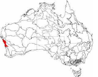
Gascoyne is an interim Australian bioregion located in Western Australia and part of the Western Australian Mulga shrublands ecoregion, as assessed by the World Wildlife Fund.
Geraldton Sandplains is an interim Australian bioregion of Western Australia and part of the larger Southwest Australia savanna ecoregion, as assessed by the World Wildlife Fund.
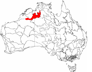
The Ord Victoria Plain, an interim Australian bioregion, is located in the Northern Territory and Western Australia, comprising 12,540,703 hectares.

Yalgoo is an interim Australia bioregion located in Western Australia, comprising 5,087,577 hectares.

The Brigalow Belt is a wide band of acacia-wooded grassland that runs between tropical rainforest of the coast and the semi-arid interior of Queensland, Australia. The Interim Biogeographic Regionalisation for Australia (IBRA) divides the Brigalow Belt into two IBRA regions, or bioregions, Brigalow Belt North (BBN) and Brigalow Belt South (BBS). The North and South Brigalow Belt are two of the 85 bioregions across Australia and the 15 bioregions in Queensland. Together they form most of the Brigalow tropical savanna ecoregion.

The Coolgardie woodlands is an ecoregion in southern Western Australia. The predominant vegetation is woodlands and mallee scrub. The ecoregion is a transitional zone between the Mediterranean-climate forests, woodlands, and shrublands of Southwest Australia and the deserts and dry scrublands of the Australian interior.

The Eyre Yorke Block, also known as the Eyre and Yorke mallee, is an interim Australian bioregion and a World Wildlife Fund ecoregion covering part of the Eyre Peninsula and all of Yorke Peninsula as well as land to its immediate east in South Australia.

The Tirari–Sturt stony desert is a deserts and xeric shrublands ecoregion in central Australia.

The Western Australian Mulga shrublands is a deserts and xeric shrublands ecoregion of inland Western Australia. It is one of Australia's two mulga ecoregions, characterized by dry woodlands of mulga trees interspersed with areas of grassland and scrub.

The Cape York Peninsula tropical savanna is a tropical grasslands, savannas, and shrublands ecoregion in northern Australia. It occupies the Cape York Peninsula in Queensland, mainland Australia's northernmost point. It is coterminous with the Cape York Peninsula, an interim Australian bioregion.

The Gulf Fall and Uplands, an interim Australian bioregion, is located in the Northern Territory and Queensland, comprising 11,847,909 hectares.
| | This article about a location in Western Australia is a stub. You can help Wikipedia by expanding it. |