Sudbury Hall is a country house in Sudbury, Derbyshire, England. One of the country's finest Restoration mansions, it has Grade I listed building status.

Lyme Park is a large estate south of Disley, Cheshire, England, managed by the National Trust and consisting of a mansion house surrounded by formal gardens and a deer park in the Peak District National Park. The house is the largest in Cheshire, and is recorded in the National Heritage List for England as a designated Grade I listed building.

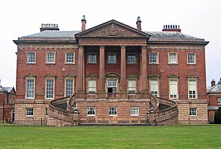
Mentmore Towers, historically known simply as "Mentmore", is a 19th-century English country house built between 1852 and 1854 for the Rothschild family in the village of Mentmore in Buckinghamshire. Sir Joseph Paxton and his son-in-law, George Henry Stokes, designed the building in the 19th-century revival of late 16th and early 17th-century Elizabethan and Jacobean styles called Jacobethan. The house was designed for the banker and collector of fine art Baron Mayer de Rothschild as a country home, and as a display case for his collection of fine art. The mansion has been described as one of the greatest houses of the Victorian era. Mentmore was inherited by Hannah Primrose, Countess of Rosebery, née Rothschild, and owned by her descendants, the Earls of Rosebery.

The River Lugg rises near Llangynllo in Radnorshire, Wales. It flows through the border town of Presteigne and then through Herefordshire, England, where it meets its main tributary, the River Arrow, to the south of Leominster. It flows into the River Wye downstream of Hereford at Mordiford, around 63 miles (101 km) from its source. Its name comes from a Welsh root, and means "bright stream".
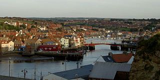
The River Esk is a river in North Yorkshire, England that empties into the North Sea at Whitby after a course of around 28 miles (45 km) through the valley of Eskdale, named after the river itself. The river's name is derived from the Brythonic word "isca" meaning "water". The Esk is the only major river in Yorkshire that flows directly into the North Sea; all other watercourses defined as being major rivers by the Environment Agency, either flow to the North Sea via the River Tees or the Humber Estuary.

Shackleford is a village and civil parish in the Borough of Guildford, Surrey, England centred to the west of the A3 between Guildford and Petersfield 32 miles (51 km) southwest of London and 5.2 miles (8.4 km) southwest of Guildford. Shackleford includes the localities of Eashing, Hurtmore, Norney and Gatwick.

Northenden is a suburb of Manchester, Greater Manchester, England, with a population of 14,771 at the 2011 census. It lies on the south side of the River Mersey, 4.2 miles (6.8 km) west of Stockport and 5.2 miles (8.4 km) south of Manchester city centre, bounded by Didsbury to the north, Gatley to the east, Sale to the west and Wythenshawe to the south.
The Landmark Trust is a British building conservation charity, founded in 1965 by Sir John and Lady Smith, that rescues buildings of historic interest or architectural merit and then makes them available for holiday rental. The Trust's headquarters is at Shottesbrooke in Berkshire.

Arthuret is a civil parish in the Carlisle district of Cumbria, England. According to the 2001 census it had a population of 2,434, increasing to 2,471 at the 2011 Census. The parish includes the town of Longtown and the village of Easton. It is bounded by the River Esk to the west and the River Lyne to the south.
Gawthorpe Hall is an Elizabethan country house on the banks of the River Calder, in Ightenhill, a civil parish in the Borough of Burnley, Lancashire, England. Its estate extends into Padiham, with the Stockbridge Drive entrance situated there. The house is traditionally attributed to Robert Smythson. In the mid-19th century, the hall was rebuilt by Charles Barry, the architect of the Houses of Parliament. Since 1953 it has been designated a Grade I listed building. In 1970 the 4th Lord Shuttleworth gave the hall to the National Trust, with a 99-year lease to Lancashire County Council. Both bodies jointly administer the hall and in 2015 the council provided £500,000 funding for restoration work on the south and west sides of the house.
Hoghton Tower is a fortified manor house two-thirds of a mile (1 km) east of the village of Hoghton, Lancashire, England, and standing on a hilltop site on the highest point in the area. It takes its name from the de Hoghton family, its historical owners since at least the 12th century. The present house dates from about 1560–65.
Canonbie is a small village in Dumfriesshire within the local authority area of Dumfries and Galloway in Scotland, 6 miles south of Langholm and 2 miles north of the Anglo-Scottish border. It is on the A7 road from Carlisle to Edinburgh, and the River Esk flows through it. There are frequent references in older documents to it as Canobie.

Richard Graham, 1st Viscount Preston PC was an English diplomat and politician who sat in the House of Commons in two periods between 1675 and 1689. He became a Jacobite conspirator, but his reputation in the Jacobite community suffered when he gave evidence against his co-conspirators in exchange for a pardon.
Bank Hall is a Jacobean mansion in Bretherton, Lancashire, England. It is a Grade II* listed building and is at the centre of a private estate, surrounded by parkland. The hall was built on the site of an older house in 1608 by the Banastres who were lords of the manor. The hall was extended during the 18th and 19th centuries. Extensions were built for George Anthony Legh Keck in 1832–1833, to the design of the architect George Webster.

Swarkestone Hall Pavilion, also known as Swarkestone Stand and The Grandstand, is a 17th-century pavilion 200 metres north of the ruins of Swarkestone Hall, Swarkestone, Derbyshire. It is a Grade I listed building south of Chellaston on the A514.

Fairfax House is a Georgian townhouse located at No. 27, Castlegate, York, England, near Clifford's Tower and York Castle Museum. It was probably built in the early 1740s for a local merchant and in 1759 it was purchased by Charles Gregory Fairfax, 9th Viscount Fairfax of Emley, who arranged for the interior to be remodelled by John Carr (architect). Fairfax was the widower of heiress Elizabeth Clifford, daughter of Hugh Clifford, 2nd Baron Clifford of Chudleigh: his inheritance from her death enabled him to purchase the house, which he intended as a home for his daughter from his first marriage, Ann Fairfax.
Arthuret is a civil parish in the Carlisle district of Cumbria, England. It contains 25 listed buildings that are recorded in the National Heritage List for England. Of these, five are listed at Grade II*, the middle of the three grades, and the others are at Grade II, the lowest grade. The parish includes the small town of Longtown and is otherwise mainly rural. Two buildings originated as fortified towers, Netherby Hall, which has been expanded converted into a country house, and Brackenhill Tower, which is part of a farm. These, and structures associated with them, are listed. Some of the listed buildings are in Longtown, including houses, hotels, a bridge, and a church. Outside these areas the listed buildings include another church with associated structures, including a holy well, and milestones.

The River Burn is a river that flows wholly within North Yorkshire, England. The river starts as several small streams on Masham Moor and drains Colsterdale flowing eastwards before emptying into the River Ure just south of Masham. Conservation work on removing a weir, and introducing fish to the river in 2016, has meant that salmon have been recorded spawning in the river for the first time in over 100 years.
The Salmon and Freshwater Fisheries Act 1923 was an Act of Parliament passed by the United Kingdom Government which attempted to consolidate fishery legislation, which at the time consisted of the Salmon Fishery Act 1861 and 18 amending Acts which had been passed subsequently.