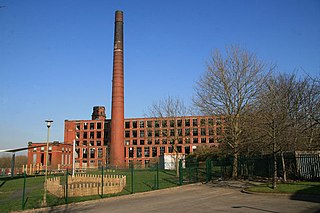
Oldham is a town in Greater Manchester, England, it lies amongst the Pennines on elevated ground between the rivers Irk and Medlock, 5 miles (8.0 km) southeast of Rochdale, and 7 miles (11.3 km) northeast of Manchester. It is the administrative centre of the Metropolitan Borough of Oldham, which had a population of 237,110 in 2019.

Chadderton is a town in the Metropolitan Borough of Oldham, Greater Manchester, England, on the River Irk and Rochdale Canal. It is located in the foothills of the Pennines, 1 mile (1.6 km) west of Oldham, 5 miles (8.0 km) south of Rochdale and 6 miles (9.7 km) north-east of Manchester.

Hulme Grammar School is a private grammar school in Oldham, Greater Manchester, England.
The Oldham Loop Line was a suburban-line in Greater Manchester, England, used by trains that ran from Manchester Victoria to Rochdale via Oldham Mumps. Services on the line at the time of its closure were operated by Northern Rail.

Oldham Werneth railway station was situated on the Oldham Loop Line, 6+1⁄4 miles (10 km) northeast of Manchester Victoria. The station was situated on Featherstall Road South, in the Werneth area of Oldham, in Greater Manchester, England. Opened on 31 March 1842 it was the oldest of the six railway stations that at one time existed in Oldham.

Shaw and Crompton is a tram stop on the Oldham and Rochdale Line (ORL) of Greater Manchester's light-rail Metrolink system. It opened to passengers on 16 December 2012 and is located in Shaw and Crompton, a part of the Metropolitan Borough of Oldham, England.
Hathershaw is an urban area of Oldham, in Greater Manchester, England. It occupies a hillside to the immediate south of Oldham town centre, and is bordered by the districts of Coppice and Fitton Hill to, respectively, the north-west and south-east. Hathershaw, which has no formal boundary or extent, is bisected from north to south by the A627 road which leads to Ashton-under-Lyne.

Werneth is an area of Oldham, Greater Manchester, England. The population at the 2011 census was 12,348. It is 1 mile (1.6 km) west-southwest of Oldham's commercial centre and one of its most ancient localities. It is contiguous with Westwood, Hollinwood, Hollins and Chadderton. Werneth includes Freehold between Werneth Park and Oldham's border with Chadderton at Block Lane.
William Henry Longworth was an English professional rugby league footballer who played in the 1900s and 1910s. He played at representative level for Great Britain, England and Lancashire, and at club level for Central Rangers ARLFC, Glodwick ARLFC (Juniors), Chadderton ARLFC, Oldham and Halifax, as a forward, during the era of contested scrums.

Blackridings Mill, Oldham was a cotton waste mill lying off Block Lane in the Werneth area of Oldham, Greater Manchester. It was built before 1861 and ceased spinning between 1875 and 1880. It was then used for flock manufacture and processing cotton waste. It was taken over by the Lancashire Cotton Corporation in the 1930s and passed to Courtaulds in 1964. Production ended in 1973 and the building was demolished in 1975.

Cowhill is a locality of Chadderton, in the Metropolitan Borough of Oldham, Greater Manchester, England.

Freehold is an urban area of Werneth in Oldham, Greater Manchester, England. It occupies an area in the west of Werneth along the Oldham township boundary with Chadderton. It is contiguous on all sides with other urban areas, including parts of Werneth to the north and east, and Cowhill, Block Lane, and Butler Green/Washbrook in Chadderton.

Coalshaw Green is a locality in the town of Chadderton in the Metropolitan Borough of Oldham, Greater Manchester.

Butler Green is a residential area in the town of Chadderton in the Metropolitan Borough of Oldham, Greater Manchester. The area is also commonly known as Washbrook.
Block Lane is a locality in the town of Chadderton in the Metropolitan Borough of Oldham, Greater Manchester. It is located on Chadderton's eastern border with Oldham, contiguous with the Freehold area of that town, and with Cowhill and Butler Green.
Garden Suburb is an area of Oldham, Greater Manchester, England, 1.9 miles to the south of the town centre, contiguous with Hollins, Copster Hill, Hollinwood and Limeside.
Hollins is an area of Oldham, Greater Manchester, England, 1.7 miles south of the town centre.
Copster Hill is a locality in the town of Oldham in Greater Manchester, lying 1.6 miles to the south of Oldham town centre.
Werneth Park is a public park in Oldham, Greater Manchester, England, including a Grade II* listed community centre, music rooms, Dame Sarah Lees Memorial, gardens and sports facilities.


