
Costa Rica is located on the Central American Isthmus, surrounding the point 10° north of the equator and 84° west of the prime meridian. It has 212 km of Caribbean Sea coastline and 1,016 on the North Pacific Ocean.

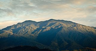
Mount Chirripó is the highest mountain in Costa Rica, with an elevation of 3,821 meters. It is part of the Cordillera de Talamanca, and the range's highest point. It is located in Chirripó National Park and is noted for its ecological wealth. The mountain was named "Chirripo", meaning "land of eternal waters", by indigenous Costa Ricans because there are many lakes and streams around the mountain. The high peaks in Chirripó National Park and La Amistad International Park host important areas of Talamancan montane forest and Costa Rican Páramo with high endemism and extremely high biodiversity. The peaks of these mountains constitute sky islands for many species of plants and animals. Snow has not fallen on the peak in the past 100 years or so, according to the University of Costa Rica, but hail is sometimes reported.

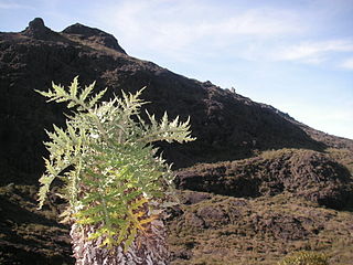
Páramo may refer to a variety of alpine tundra ecosystems located in the Andes Mountain Range, South America. Some ecologists describe the páramo broadly as "all high, tropical, montane vegetation above the continuous timberline". A narrower term classifies the páramo according to its regional placement in the northern Andes of South America and adjacent southern Central America. The páramo is the ecosystem of the regions above the continuous forest line, yet below the permanent snowline. It is a "Neotropical high mountain biome with a vegetation composed mainly of giant rosette plants, shrubs and grasses". According to scientists, páramos may be "evolutionary hot spots", that meaning that it's among the fastest evolving regions on Earth.

Tapantí - Cerro de la Muerte Massif National Park,, is a National Park in the Central Conservation Area of Costa Rica located on the edge of the Talamanca Range, near Cartago. It protects forests to the north of Chirripó National Park, and also contains part of the Orosí River. The area known as Cerro de la Muerte Massif was added to the park on January 14, 2000.
Chirripó National Park is a national park of Costa Rica, encompassing parts of three provinces: San José, Limón and Cartago. It was established in 1975.

Barbilla National Park is a National Park in the Caribbean La Amistad Conservation Area of Costa Rica located on the eastern slopes of the Cordillera de Talamanca. It protects forests as well as Laguna Ayil and Cerro Tigre and the Dantas River watershed, covering parts of both Cartago and Limón Provinces. It was initially established in 1982.
Cerro de la Muerte is a mountain peak of a massif in Costa Rica, it is located within the Tapantí — Cerro de la Muerte Massif National Park, and is the highest point on the Pan-American Highway.

The Talamancan montane forests ecoregion, in the tropical moist broadleaf forest biome, are in montane Costa Rica and western Panama in Central America.
Cerro Kamuk is a mountain in the Cordillera de Talamanca, in La Amistad International Park, in eastern Costa Rica, close to the border with Panama. It rises to 3,549 metres (11,644 ft) above sea level. It is one of the highest mountains in Central America. Indigenous peoples of the area include the Bribris and Cabecar. The area protected comprised four national parks clustered together that became La Amistad Biosphere Reserve. UNESCO declared it a natural World Heritage Site in 1983. It is part of the Mesoamerican Biological Corridor, UNESCO's project shared by eight Central American countries to help protect the remaining pristine mountain forest and wildlife of Central America.
The Costa Rican páramo, also known as the Talamanca páramo, is a natural region of montane grassland and shrubland of Costa Rica and western Panama.
Isthmohyla calypsa is a species of frogs in the family Hylidae. It is known from the southern Cordillera de Talamanca in Costa Rica, Cerro Pando in Costa Rica and Panama, and the Pacific slope in southwestern Panama. It appears to now be extirpated from Costa Rica. Prior to its description in 1996, this species was confused with Isthmohyla lancasteri, a species now known from lower altitudes only.
Isthmohyla lancasteri is a species of frog in the family Hylidae. It is endemic to humid premontane slopes of the Cordillera de Talamanca in Costa Rica and western Panama.
Pérez Zeledón is the nineteenth canton of the province of San José in Costa Rica, located in the Brunca region. The capital city of the canton is San Isidro de El General.
The crater salamander, also known as the marbled crater salamander, is a species of salamander in the family Plethodontidae. It is endemic to Costa Rica and Panama. Its natural habitat is subtropical, high-altitude moist montane forests. It has a small area of distribution and is threatened by habitat loss therein.

Dice's cottontail is a species of cottontail rabbit in the family Leporidae. It is found in Costa Rica and Panama, in páramo and cloud forest habitats.

The Cerro de la Muerte Biological Station is one of the several field stations for biological research that exist in Costa Rica.

The La Amistad International Park, or in Spanish Parque Internacional La Amistad, formerly the La Amistad National Park, is a Transboundary Protected Area in Latin America, management of which is shared between Costa Rica and Panama, following a recommendation by UNESCO after the park's inclusion in the World Heritage Site list in 1983. The park and surrounding biosphere reserve is one of the most outstanding conservation areas in Central America, preserving a major tract of tropical forest wilderness. It is world-renowned for its extraodinary biodiversity and endemism.

The Northwestern Andean montane forests (NT0145) is an ecoregion on the Andes mountains in the west of Colombia and Ecuador. Both flora and fauna are highly diverse due to effect of ice ages when the warmer climate zones were separated and the cooler ones combined, and interglacial periods when the reverse occurred. Because the environment is hospitable to humans, the habitat has been drastically modified by farming and grazing since the Pre-Columbian era.

Sciodaphyllum pittieri is a species of flowering plant in genus Sciodaphyllum. It is native to the mountain forests of Costa Rica and western Panama.

