
Davis Square is a major intersection in the northwestern section of Somerville, Massachusetts, United States, where several streets meet: Holland Street, Dover Street, Day Street, Elm Street, Highland Avenue, and College Avenue. The name is often used to refer to the West Somerville neighborhood surrounding the square as well.

Cleveland Circle is an area of Boston, Massachusetts. It is located at the southern tip of Boston's Brighton neighborhood, and more specifically the Aberdeen section of Brighton, in close proximity to Brookline and Chestnut Hill, Massachusetts, at the intersection of Beacon Street and Chestnut Hill Avenue.
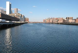
Fort Point Channel is a maritime channel separating South Boston from downtown Boston, Massachusetts, feeding into Boston Harbor. The south part of it has been gradually filled in for use by the South Bay rail yard and several highways. At its south end, the channel once widened into South Bay, from which the Roxbury Canal continued southwest where the Massachusetts Avenue Connector is now. The Boston Tea Party occurred at its northern end. The channel is surrounded by the Fort Point neighborhood, which is also named after the same colonial-era fort.
Winter Hill is a neighborhood in Somerville, Massachusetts, United States. It takes its name from the 120-foot hill that occupies its landscape, the name of which dates back to the 18th century. Winter Hill is located roughly north of Medford Street, west of McGrath Highway, and east of Magoun Square.
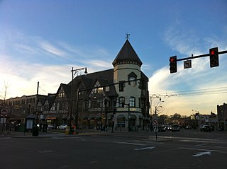
Coolidge Corner is a neighborhood of Brookline, Massachusetts, United States, centered on the intersection of Beacon Street and Harvard Street. The neighborhood takes its name from the Coolidge & Brother general store that opened in 1857 at that intersection at the site of today's S.S. Pierce building, which was for many years the only commercial business in north Brookline.

Olmsted Park is a linear park in Boston and Brookline, Massachusetts, and a part of Boston's Emerald Necklace of connected parks and parkways. Originally named Leverett Park, in 1900 it was renamed to honor its designer, Frederick Law Olmsted.

The Berkeley Rose Garden is a city-owned park in the North Berkeley area of Berkeley, California. The rose garden is situated in a residential area of the Berkeley Hills between the Cragmont and the La Loma Park neighborhoods, occupying most of the block between Eunice Street and Bayview Place along the west side of Euclid Avenue, and west of Codornices Park.

Mission Hill is a 3⁄4 square mile, primarily residential neighborhood of Boston, bordered by Roxbury, Jamaica Plain and Fenway-Kenmore and the town of Brookline. The neighborhood has two main streets, namely Tremont Street and Huntington Ave. It is served by several stations on the MBTA's Green Line E branch, as well as Roxbury Crossing station on the Orange Line.

Fenway station is a light rail stop on the MBTA Green Line D branch, located under Park Drive near the Riverway in the Fenway–Kenmore neighborhood of Boston, Massachusetts. It opened along with the rest of the D branch on July 4, 1959, when trolleys replaced Highland branch commuter rail service. The station is fully accessible from Park Drive via the Landmark Center parking lot, as well as from Miner Street. Named after the Fenway parkway rather than Fenway Park, it is further from the stadium than Kenmore, though still used during events.

Forest Hills is a part of the Jamaica Plain neighborhood of Boston, Massachusetts, United States. Forest Hills is characterized by hilly terrain and wooded areas within and adjacent to its borders. In general, the area slopes upward from Hyde Park Ave and downward from Walk Hill Street.
Washington Square is a neighborhood in Brookline, Massachusetts, United States.

Boylston Street is a major east–west thoroughfare in the city of Boston, Massachusetts and its western suburbs. The street begins in Boston's Chinatown neighborhood, forms the southern border of the Boston Public Garden and Boston Common, runs through Back Bay and Boston's Fenway neighborhood, merges into Brookline Ave and then Washington Street, emerging again contiguous with Route 9 out to where it crosses Route 128, after which it becomes Worcester Street.
The East Side is a collection of neighborhoods in the eastern part of the city of Providence, Rhode Island. It officially comprises the neighborhoods of Blackstone, Hope, Mount Hope, College Hill, Wayland, and Fox Point.

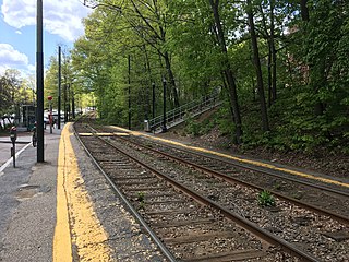
Fairbanks Street station is a light rail stop on the MBTA Green Line C branch in Brookline, Massachusetts, located in the median of Beacon Street. Fairbanks station has two side platforms serving the line's two tracks. It is not accessible, although a wheelchair lift allows accessible transfer between the two elevations of the two halves of Beacon Street at the station.

Lansdowne station is an MBTA Commuter Rail station in Boston, Massachusetts. It serves the Framingham/Worcester Line. Lansdowne is located next to the Massachusetts Turnpike in the Fenway–Kenmore neighborhood near Kenmore Square, below grade between Beacon Street and Brookline Avenue.
Brandon Hall station is a light rail stop on the MBTA Green Line C branch in Brookline, Massachusetts. The station's name is an anachronism, as it was named for Brandon Hall, a large hotel built in 1904 just south of the station which burned down on April 26, 1946, after housing 400 SPARS during World War II.
Pill Hill, also known as "High Street Hill," is a neighborhood of Brookline, Massachusetts, United States, and part of Greater Boston.
Brigham Circle is located at the intersection of Tremont Street and Huntington Avenue in the Mission Hill neighborhood of Boston, Massachusetts. The commercial center of Mission Hill, it forms the southern tip of the Longwood Medical Area.

Dornoch Terrace Bridge is a heritage-listed road bridge at Dornoch Terrace, West End, Queensland, Australia. It was added to the Queensland Heritage Register on 1 October 2007.

Jacob's Ladder is a landmark in Brisbane, Queensland, Australia. It is a long pedestrian staircase that extends from Edward and Turbot Streets up to Wickham Terrace. The name is a reference to the Biblical stairway ascending to Heaven. Jacob's Ladder has 86 steps.
